Kotohira (Kagawa)
| Kotohira (Kagawa) -chō 琴 平 町 |
||
|---|---|---|
| Geographical location in Japan | ||
|
|
||
| Region : | Shikoku | |
| Prefecture : | Kagawa | |
| Coordinates : | 34 ° 11 ' N , 133 ° 49' E | |
| Basic data | ||
| Surface: | 8.46 km² | |
| Residents : | 8624 (October 1, 2019) |
|
| Population density : | 1019 inhabitants per km² | |
| Community key : | 37403-2 | |
| Symbols | ||
| Flag / coat of arms: | ||
| Tree : | cherry | |
| Flower : | Real verbena | |
| town hall | ||
| Address : |
Kotohira (Kagawa) Town Hall 817 - 10 , Enai Kotohira (Kagawa) -chō, Nakatado-gun Kagawa 766-8502 |
|
| Website URL: | http://www.town.kotohira.kagawa.jp/ | |
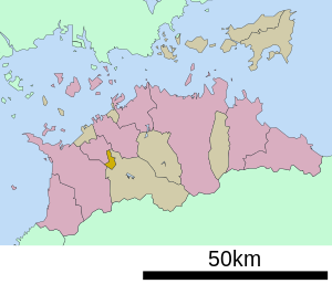
| Location of Kotohira in Kagawa Prefecture | ||
Kotohira ( Japanese 琴 平 町 , - chō ) is a city in Nakatado district of Kagawa Prefecture in Japan . Mayor is Masato Ono (as of 2016). The city was named after an ancient sea god, Kotohiragu.
geography
The mean temperature is 16.7 ° C with an average annual rainfall of 817.5 mm.
Attractions
The city is known as the location of the largest Shinto shrine complex on Shikoku Island , the Kotohira-gū (also Kompira-san ).
Next to the Kotohira-gū is Japan's oldest surviving kabuki theater, Kanamaruza .
Every year on October 10th there is a big festival in the city.
Neighboring cities and communities
swell
- http://www.japan-guide.com/e/e5450.html
- Town Data ( Memento from August 9, 2011 in the Internet Archive )
Web links
Commons : Kotohira (Kagawa) - collection of pictures, videos and audio files


