Imabari
| Imabari-shi 今 治 市 |
||
|---|---|---|
| Geographical location in Japan | ||
|
|
||
| Region : | Shikoku | |
| Prefecture : | Ehime | |
| Coordinates : | 34 ° 4 ' N , 133 ° 0' E | |
| Basic data | ||
| Surface: | 419.85 km² | |
| Residents : | 151,956 (October 1, 2019) |
|
| Population density : | 362 inhabitants per km² | |
| Community key : | 38202-7 | |
| Symbols | ||
| Flag / coat of arms: | ||
| Tree : | Camphor tree | |
| Flower : | azalea | |
| town hall | ||
| Address : |
Imabari City Hall 1 - 4 - 1 , Bekku-chō Imabari -shi Ehime 794-8511 |
|
| Website URL: | www.city.imabari.ehime.jp | |
| Location Imabaris in Ehime Prefecture | ||
Imabari ( Japanese 今 治 市 - shi ) is a city in Ehime Prefecture .
geography
Imabari extends to the north of the Takanawa Peninsula of Shikoku Island and over the Kurushima (see also Kurushima ) and Ochi Islands, which are separated from it by the Kurushima Strait .
Attractions
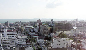
Imabari has a long history due to its strategic location. The Castle Imabari in today's city center, the moat is connected with the sea, is one of the few moated castles of Japan. It was built in 1604 at the beginning of the Edo period by the local daimyo Tōdō Takatora . After the Meiji Restoration , the new government had all of the castle's buildings destroyed from 1873 onwards. It was not until 1980 that the city administration rebuilt the Donjon (Tenshu). However, it is only a concrete reconstruction that imitates the external appearance. The interior offers space for various exhibitions relating to armaments, weapons and documents and is also home to the city's natural history museum.
Of the 88 station stamps on the traditional Buddhist Shikoku pilgrimage route , six, nos. 54–59, are in Imabari.
traffic
The Nishiseto Highway (also called Shimanami-kaidō), which connects Imabari over a total of ten bridges and several smaller islands in the Seto Inland Sea with Onomichi in Hiroshima Prefecture, is of great importance for the city . Opened in 1999 after 24 years of construction, this bridge system is the third between Honshū and Shikoku after Seto-Ōhashi (opened in 1988) and the Kobe-Awaji-Naruto highway (opened in 1998).
Imari is also on the JR Shikoku- operated Yosan Line from Takamatsu to Uwajima .
economy
In addition to the fishing port and the food industry, wood processing is an economic focus of the city.
Imabari is also a cotton processing center specializing in towels, for which it is also known internationally. This began in 1894 when Abe Heisuke introduced new cotton looms. When the domestic production lost market share due to cheaper foreign competition, the towel production in Imabari survived due to its concentration on higher quality products and the introduction of a seal of approval, so that in 2010 about 50% of the total domestic production came from Imabari.
Town twinning
sons and daughters of the town
- Nagai Kenji (1957-2007), photojournalist
- Kanta Kondō (* 1993), football player
- Takashi Ochi (1934-2010), mandolin virtuoso
- Hajime Sorayama (* 1947), painter
Adjacent communities
Web links
Individual evidence
- ↑ Imabari Towel. In: Japan Brand. Retrieved November 11, 2017 .


