Shikokuchūō
| Shikokuchūō-shi 四 国 中央 市 |
||
|---|---|---|
| Geographical location in Japan | ||
|
|
||
| Region : | Shikoku | |
| Prefecture : | Ehime | |
| Coordinates : | 33 ° 59 ' N , 133 ° 33' E | |
| Basic data | ||
| Surface: | 420.48 km² | |
| Residents : | 83,630 (October 1, 2019) |
|
| Population density : | 199 inhabitants per km² | |
| Community key : | 38213-2 | |
| Symbols | ||
| Flag / coat of arms: | ||
| town hall | ||
| Address : |
Shikokuchūō City Hall 4 - 6 - 55 , Miyagawa, Mishima Shikokuchūō -shi Ehime 799-0497 |
|
| Website URL: | https://www.city.shikokuchuo.ehime.jp | |
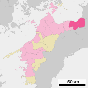
| Location Shikokuchūōs in Ehime Prefecture | ||
Shikokuchūō ( Japanese 四 国 中央 市 , -shi , Eng. Shikoku middle ) is a city in Ehime Prefecture on the north coast of Shikoku Island in Japan .
geography
Shikokuchūō is east of Matsuyama and Niihama , and west of Takamatsu .
history
Shikokuchūō was formed on April 1, 2004 from the union of the cities of Iyomishima ( 伊 予 三島 市 , -shi ) and Kawanoe ( 川 之 江 市 , -shi ), the municipality of Doi ( 土 居 町 , -chō ), and the village of Shingū ( 新 宮 村 , -mura ) of Uma County. The district was then dissolved.
Attractions
- Kawanoe Castle ( 川 之 江城 , Kawanoe-jō )
Town twinning
traffic
- Street:
- Matsuyama Highway
- Kochi Highway
- National Road 11 : to Tokushima and Matsuyama
- National roads 192,319
- Train:
- JR Yosan Line : to Takamatsu or Uwajima
Neighboring cities and communities
Web links
Commons : Shikokuchūō - collection of images, videos and audio files


