Kumakōgen (Ehime)
| Kumakōgen-chō 久 万 高原 町 |
||
|---|---|---|
| Geographical location in Japan | ||
|
|
||
| Region : | Shikoku | |
| Prefecture : | Ehime | |
| Coordinates : | 33 ° 39 ' N , 132 ° 54' E | |
| Basic data | ||
| Surface: | 583.69 km² | |
| Residents : | 7485 (October 1, 2019) |
|
| Population density : | 13 inhabitants per km² | |
| Community key : | 38386-4 | |
| Symbols | ||
| Flag / coat of arms: | ||
| Tree : | Crescent fir | |
| Flower : | Lilium japonicum | |
| town hall | ||
| Address : |
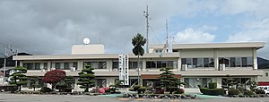
Kumakōgen Town Hall 212 Kuma Kumakōgen -chō, Kuma-gun Ehime 791-1201 |
|
| Website URL: | http://www.town.kumakogen.ehime.jp/ | |
| Location of Kumakōgens in Ehime Prefecture | ||
Kumakōgen ( Japanese 久 万 高原 町 , - chō ) is a town in the district of Kamiukena ( 上浮 穴 郡 ) in Ehime Prefecture on Shikoku in Japan .
There is also, as part of the Kumakōgen Furusato Ryokōmura ( 久 万 高原 ふ る さ と 旅行 村 , German "home and excursion village Kumakōgen"), the Kuma-Kōgen observatory settled.
geography
The community extends over the Shikoku Mountains , with the Ishizuchi-zan at 1982 m above sea level on the northeastern boundary of the community being the highest point in Shikoku. Therefore, despite its extension of 583.66 km² with 7485 inhabitants, the municipality is quite poor in population. The population concentrates on the few valleys of the source rivers of the Niyodo-gawa that run through the mountains.
history
The city was created on August 1, 2004 from the merger of the city of Kuma , and the villages of Mikawa , Omogo and Yanadani , making it the only municipality in the district today. The newly chosen name of the community literally means "Kuma plateau (s)".
traffic
The most important roads are national roads 33 to Kōchi or Matsuyama , 380 to Yawatahama , 440 to Matsuyama or Yusuhara and 494 to Matsuyama or Susaki . There is no connection to the rail network.


