Shabelle
| Shabelle | ||
|
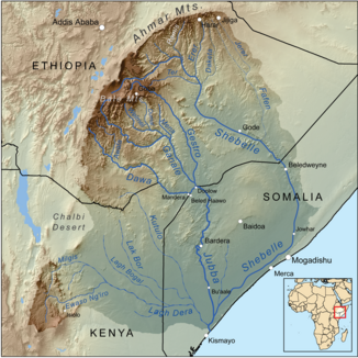
Catchment area of the Jubba |
||
| Data | ||
| location |
|
|
| River system | Juba | |
| Drain over | Juba → Indian Ocean | |
| Headwaters | in the Mendebo Mountains | |
| muzzle | in the Juba coordinates: 0 ° 9 ′ 47 " N , 42 ° 45 ′ 32" E 0 ° 9 ′ 47 " N , 42 ° 45 ′ 32" E
|
|
| length | 1820 km | |
| Catchment area | 336,627 km² | |
| Discharge at the Belet Uen gauge (1878500) A Eo : 211,800 km² |
NNQ (min. Month Ø) MNQ 1951–1979 MQ 1951–1979 Mq 1951–1979 MHQ 1951–1979 HHQ (max. Month Ø) |
0 l / s 13.5 m³ / s 68 m³ / s 0.3 l / (s km²) 145 m³ / s 301 m³ / s |
| Discharge at the Afgoi gauge (1878100) A Eo : 278,000 km² |
NNQ (min. Month Ø) MNQ 1951–1979 MQ 1951–1979 Mq 1951–1979 MHQ 1951–1979 HHQ (max. Month Ø) |
0 l / s 8 m³ / s 46 m³ / s 0.2 l / (s km²) 86.3 m³ / s 112 m³ / s |
| Left tributaries | Galeti , Erer , Dakatu , Fafen | |
| Right tributaries | Ter | |
|
Satellite image of floods in the central Shabelle Valley in Ethiopia and southern Somalia, 2005 |
||
The Shabelle ( Somali Shabeelle , in Ethiopia also Shebele or Shebeli, Amharic ሸበሌ ወንዝ Šäbälle wänz, Italian Scebeli; sometimes with the addition Uebi , Webi , Wabi or Wabe ) is a river in Ethiopia and Somalia that is at least 1820 km long .
Shabeel means "leopard" in Somali.
geography

The river has its source in the southwest of the Somali highlands in the Mendebo Mountains near Awassa and Yirga Alem . Its source is venerated as a holy place by the Sidama as well as by the Arsi - Oromo . The Shabelle flows first in an easterly and then in a south-easterly direction along the Audo Mountains through south-eastern Ethiopia ( Somali region / Ogaden ). About halfway through its course, it crosses the border into Somalia. In an elongated arc to the right, its water heads south towards Mogadishu , but without touching the capital of Somalia. Rather, the Shabeelle meanders in a south-westerly direction through the hinterland of the Benadir coast of the Indian Ocean , which it accompanies over 400 kilometers at intervals of around 20 to 30 kilometers, silting up over long stretches in the dry season . The confluence with the Juba, south of Jilib and Kamsuuma in the Jubbada Hoose region , reaches the water of the Shabelle, in parts without a recognizable river bed, only in particularly productive rainy seasons with heavy rainfall and floods. This estuary is about 50 kilometers north of the point where the Juba in turn flows into the Indian Ocean.
Significant places along the river are Gode , Kalafo and Mustahil in Ethiopia and Beledweyne , Buulobarde , Jawhar and Afgooye in Somalia. The Shabelle formed the northern border of Bale in Ethiopia and gave the administrative regions Shabeellaha Dhexe (Middle Shabelle) and Shabeellaha Hoose (Sub-Shabelle) in Somalia the name. At Melka Wakena on the upper reaches, it has been dammed since 1989 to generate electricity.
Several seasonal tributaries such as the Erer , Fafen , Galeti and Jerer flow from the Harar Plateau through the Ethiopian Somali region into the Shabelle from the north.
Hydrometry
The flow rate of the river was measured over 28 years (1951–79) in Belet Uen and Afgooye in m³ / s. The river loses its flow rate over the 400 kilometers due to the aridity of the climate and branching irrigation canals within Somalia: In Belet Uen the average annual flow rate is 68 m³ / s, in Afgooye, however, only 46 m³ / s.
The values from Afgooye are shown here in m³ / s.

See also
Individual evidence
- ↑ a b Details on the length differ considerably from one another. The figures range from 1,100 kilometers ( Central Statistics Agency of Ethiopia , see Climate, 2008 National Statistics (Abstract) , Table A.1.) To 2,488 kilometers (Caterina Madau, Gavino Mariotti: Vie fluviali, tematismo privilegiato nella cartografia degli esploratori italiani dell ' Africa Orientale: tra proposte, polemiche, informazione ( page no longer available , search in web archives ) Info: The link was automatically marked as defective. Please check the link according to the instructions and then remove this notice. , 2004)
- ↑ Watersheds of the World ( Memento of the original dated November 30, 2008 in the Internet Archive ) Info: The archive link was automatically inserted and not yet checked. Please check the original and archive link according to the instructions and then remove this notice.
- ↑ a b GRDC level data from Belet Uen
- ↑ a b GRDC level data from Afgooye
- ^ J. Spencer Trimingham: Islam in Ethiopia , Geoffrey Cumberlege for the University Press, Oxford 1952, p. 260
- ↑ Measure distances with google maps

