
Shabeellaha Hoose
| Shabeellaha Hoose | |
|---|---|
  |
|
| Basic data | |
| Country | Somalia |
| Capital | Merka |
| surface | 25,285 km² |
| Residents | 1,202,219 (calculation 2013) |
| density | 48 inhabitants per km² |
| ISO 3166-2 | SO-SH |
Coordinates: 1 ° 49 ' N , 44 ° 45' E
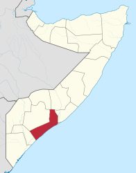
Shabeellaha Hoose ( Somali for sub- Shabelle ; Arabic شبيلي السفلى, DMG Šabailī as-Suflā ) is a region ( gobolka ) in southern Somalia . Its capital is Merka with about 350,000 inhabitants.
The region is named after the Shabelle River through which it flows. It is located on the Indian Ocean , south of Mogadishu . Like Shabeellaha Dhexe (Middle Shabelle), it used to be part of the Benadir region with the state capital Mogadishu as its capital. Other cities and places besides Merka are Afgooye , Qoryooley , Baraawe , Janaale and Wanlaweyne .
The main Somali - clans in Lower Shebelle, the Hawiye and the Biyomaal- you , besides there is a significant Digil -Minderheit. The Bantu ethnic minority in Somalia and other small groups are also represented here. These ethnic groups speak different dialects of Somali.
Conflicts and the influx of internally displaced persons from the embattled state capital Mogadishu led in 2007 to a deterioration in the food situation in the region, which was traditionally regarded as the “bread basket of the country”.
In Shabeellaha Hoose itself, the Islamist groups al-Shabaab and Hezbul Islam have consolidated their control. The region is largely peaceful under their rule, but the Islamists also enforce a strict interpretation of the Sharia .
In 2013 the attempted hostage rescue in Bulo Marer failed .
Web links
Individual evidence
- ↑ population estimation survey 2014 ( UNFPA ) table A3
- ↑ Somalia: Malnutrition stalks once fertile region , in: IRIN News: September 27, 2007
- ↑ Malnutrition increases as humanitarian emergency worsens in the Shabelles , in: IRIN News, November 1, 2007
- ^ Somali road trip to Islamist heartland , in: BBC News, October 29, 2009
Bakool | Banaadir | Bay | Galguduud | Gedo | Hiiraan | Jubbada Dhexe | Jubbada Hoose | Shabeellaha Dhexe | Shabeellaha Hoose
Puntland Bari / Karkaar | Mudug | Nugaal
Somaliland Awdal | Sanaag | Sool | Togdheer | Woqooyi Galbeed (Maroodi Jeex) | Saaxil
| Colonial times |
|
||||||
| After the Second World War |
|
||||||
|
From independence to civil war |
|
||||||
|
Civil war period, collapse of the central state (claims to recognition) |
|
||||||
| New constitution from 2012 |
|