Rutland County
 Rutland County Courthouse |
|
| administration | |
|---|---|
| US state : | Vermont |
| Administrative headquarters : | Rutland |
| Address of the administrative headquarters: |
County Courthouse 83 Center Street Rutland, VT 05701-4017 |
| Foundation : | 1781 |
| Made up from: | Bennington County |
| Area code : | 001 802 |
| Demographics | |
| Residents : | 61,642 (2010) |
| Population density : | 25.5 inhabitants / km 2 |
| geography | |
| Total area : | 2447 km² |
| Water surface : | 32 km² |
| map | |
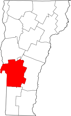
Rutland County is a county in the US state of Vermont in the United States . The county seat is in Rutland .
geography
The county borders New York to the west and has an area of 2,447 square kilometers, of which 32 square kilometers are water. It is bordered clockwise by the following counties: Addison County , Windsor County , Bennington County, and Washington County, New York.
history
Rutland County was formed from parts of Bennington County in February 1781.
Demographic data
| Population development | |||
|---|---|---|---|
| Census | Residents | ± in% | |
| 1790 | 15,590 | - | |
| 1800 | 23,813 | 52.7% | |
| 1810 | 29,486 | 23.8% | |
| 1820 | 29,983 | 1.7% | |
| 1830 | 31,294 | 4.4% | |
| 1840 | 30,699 | -1.9% | |
| 1850 | 33,059 | 7.7% | |
| 1860 | 35,946 | 8.7% | |
| 1870 | 40,651 | 13.1% | |
| 1880 | 41,829 | 2.9% | |
| 1890 | 45.397 | 8.5% | |
| 1900 | 44.209 | -2.6% | |
| 1910 | 48.139 | 8.9% | |
| 1920 | 46.213 | -4% | |
| 1930 | 48,453 | 4.8% | |
| 1940 | 45,638 | -5.8% | |
| 1950 | 45.905 | 0.6% | |
| 1960 | 46,719 | 1.8% | |
| 1970 | 52,637 | 12.7% | |
| 1980 | 58,347 | 10.8% | |
| 1990 | 62,142 | 6.5% | |
| 2000 | 63,400 | 2% | |
| 2010 | 61,642 | -2.8% | |
| 1790-1890, 1900-1990, 2000 | |||
According to the 2000 census , the county had 63,400 people. There were 25,678 households and 16,742 families. The population density was 26 inhabitants per square kilometer. The racial the population was composed of 98.13% white, 0.33% African American, 0.23% Native American, 0.39% Asian, 0.03% residents from the Pacific island area and 0.17% from others ethnic groups; 0.73% were from two or more races. Hispanic or Latino of any race was 0.70% of the population.
Of the 25,678 households, 29.80% had children and young people under the age of 18 living with them. 51.30% were married couples living together, 10.10% were single mothers. 34.80% were not families. 27.90% are single households and 11.20% have someone who is 65 years of age or older. The average household size was 2.39 and the average family size was 2.92 people.


For the entire county, the population was composed of 23.20% of residents under 18 years of age, 8.30% between 18 and 24 years of age, 27.70% between 25 and 44 years of age, 25.80% between 45 and 64 years of age 15.00% were 65 years of age or over. The average age was 40 years. For every 100 females there were 94.70 males, and for every 100 females aged 18 and over there were 92.00 males.
The median income for a household in the 36,743 USD , and the median income for a family was 44,742 USD. Males had a median income of $ 31,094 versus $ 23,964 for females. The per capita income was $ 18,874. 10.90% of the population and 7.10% of families are below the poverty line. 13.30% of them were under 18 years of age and 8.80% were 65 years of age or older.
cities and communes
In addition to the 27 independent towns and one city listed below, there is the following village with independent rights in Rutland County , which is co-administered by the superordinate town: Poultney Village . There are also the census-designated placees for statistical purposes : Benson, Brandon, Castleton, Fair Haven, Pittsford, Wallingford, Wells and West Rutland as well as the Unincorporated Villages Belmont, Bomoseen, Center Rutland, Cuttingsville, East Poultney, Florence, Forest Dale, Hortonia, Hortonville, Hydeville and North Clarendo.
| Locality | status | Population (2010) |
Total area [km²] |
Land area [km²] |
Population density [inhabitants / km²] |
founding | Specialty |
|---|---|---|---|---|---|---|---|
| Benson | town | 1,056 | 117.9 | 113.9 | 9.3 | May 5, 1780 | |
| Brandon | town | 3,966 | 104.0 | 103.9 | 38.7 | Oct. 20, 1761 | |
| Castleton | town | 4,717 | 109.7 | 100.7 | 46.8 | 22 Sep 1761 | |
| Chittenden | town | 1,258 | 191.4 | 188.0 | 6.7 | 16. Mar. 1780 | |
| Clarendon | town | 2,571 | 81.7 | 81.7 | 31.5 | 5th Sep 1761 | |
| Danby | town | 1.311 | 107.6 | 107.3 | 12.2 | 27 Aug 1761 | |
| Fair Haven | town | 2,734 | 47.0 | 45.2 | 60.5 | Oct. 27, 1779 | |
| Hubbardton | town | 706 | 74.7 | 71.1 | 9.9 | June 15, 1764 | |
| Ira | town | 432 | 55.2 | 55.2 | 7.8 | Oct 12, 1780 | |
| Killington | town | 811 | 121.4 | 120.8 | 6.7 | July 7, 1761 | |
| Mendon | town | 1,059 | 98.7 | 98.6 | 10.7 | 23 Feb 1761 | |
| Middletown Springs | town | 745 | 59.2 | 59.2 | 12.6 | Oct 28, 1784 | |
| Mount Holly | town | 1,237 | 128.4 | 127.4 | 9.7 | Oct 31, 1792 | |
| Mount Tabor | town | 255 | 113.4 | 113.3 | 2.3 | 28 Aug 1761 | |
| Pawlet | town | 1,477 | 111.1 | 111.1 | 13.3 | Aug 26, 1761 | |
| Pittsfield | town | 546 | 53.0 | 52.8 | 10.3 | July 29, 1781 | |
| Pittsford | town | 2,991 | 113.1 | 112.2 | 26.7 | Oct 12, 1761 | |
| Poultney | town | 3,432 | 116.0 | 113.7 | 30.2 | 21 Sep 1761 | |
| Proctor | town | 1,741 | 112.1 | 112.0 | 15.5 | Nov 18, 1886 | |
| Rutland | town | 4,054 | 50.0 | 49.9 | 81.1 | Sep 7 1761 | |
| Rutland (City) | City | 16,495 | 20.0 | 19.9 | 828.9 | Nov 17, 1892 | County Seat |
| Shrewsbury | town | 1,056 | 130.0 | 129.6 | 8.1 | 4th Sep 1761 | |
| Sudbury | town | 560 | 57.6 | 55.6 | 10.1 | Aug 6, 1763 | |
| Tinmouth | town | 613 | 73.6 | 73.3 | 8.4 | Sep 15 1761 | |
| Wallingford | town | 2,079 | 112.5 | 112.0 | 18.6 | Nov. 27, 1761 | |
| Wells | town | 1,150 | 60.5 | 58.4 | 19.7 | Sep 15 1761 | |
| West Haven | town | 264 | 73.7 | 72.1 | 3.7 | Oct. 20, 1792 | |
| West Rutland | town | 2,326 | 46.6 | 46.6 | 49.9 | Nov 19, 1886 |
Individual evidence
- ^ Rutland County in the Geographic Names Information System of the United States Geological Survey . Retrieved February 22, 2011
- ^ Zadock Thompson: History of Vermont: natural, civil, and statistical, in three parts . 3rd volume. George H. Salisbury, Burlington 1842, p. 154 ( limited preview in Google Book search).
- ↑ Preparation of historical data from the University of Virginia
- ↑ Extract from Census.gov . Retrieved February 28, 2011
- ↑ Excerpt from factfinder.census.gov.Retrieved February 28, 2011
- Jump up ↑ Rutland County, Vermont , 2000 census datasheet at factfinder.census.gov .
- ↑ Population data from the 2010 US Census in the American Factfinder
- ↑ All founding dates according to the corresponding individual entries on VirtualVermont.com ( Memento from January 1, 2012 in the Internet Archive )
Web links
Coordinates: 43 ° 34 ′ N , 73 ° 2 ′ W

