Sidi bel Abbès
|
سيدي بلعباس ⵙⵉⴷⵉ ⴱⴻⵍ ⵄⴻⴱⴱⴰⵙ Sidi bel Abbès |
||
|---|---|---|
|
|
||
| Coordinates | 35 ° 11 '59 " N , 0 ° 37' 53" W | |
| Symbols | ||
|
||
| Basic data | ||
| Country | Algeria | |
| Sidi Bel Abbès | ||
| ISO 3166-2 | DZ-22 | |
| height | 470 m | |
| surface | 70 km² | |
| Residents | 212,935 (2008) | |
| density | 3,041.9 Ew. / km² | |
|
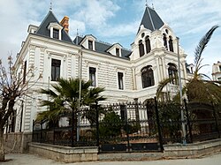
Sidi bel Abbès - Town Hall
|
||
Sidi bel Abbès ( Arabic سيدي بلعباس, DMG Sīdī Bu-l-ʿAbbās , tamazight ⵙⵉⴷⵉ ⴱⴻⵍ ⵄⴻⴱⴱⴰⵙ Sidi bel ɛebbas ) is the capital of the province of the same name in northwest Algeria with around 230,000 inhabitants . At the same time it is the capital of a municipality (commune) with a total of approx. 250,000 inhabitants. The city is named after an 18th century Muslim saint who was buried here .
location
Sidi bel Abbès is about 90 km (driving distance) south of the Mediterranean coast near Oran in a high valley of the Tell Atlas at an altitude of about 470 m . The climate is temperate to warm; Rain (approx. 460 mm / year) falls mainly in the winter months.
population
| year | 1977 | 1987 | 1998 | 2008 |
| Residents | 112,988 | 152.778 | 183.931 | 210.146 |
Since the 1960s, Sidi bel Abbès has experienced a high level of immigration by families from the rural regions of Algeria.
economy
The cultivation of grain is the main industry in the region; but also wine and various types of fruit were planted. An irrigation system adopted from Andalusia was able to increase the yield of the harvest .
traffic
Sidi bel Abbès has a train station on the Oran – Akid Abbès line of the SNTF . A 14 km long tram network was opened on July 25, 2017 .
history
In 1843 the French established a military outpost near the village of Sidi bel Abbès and within a few years created a city based on the French model. This became a center of the Foreign Legion and grew rapidly. From 1831 to 1962 the mother house ( maison mère ) of the Foreign Legion with the 1st Foreign Regiment was located in the city of Viénot . Due to the rapid growth of the city, its traditional structure disappeared.
When Algeria's independence was proclaimed on July 5, 1962 after the Algerian War, the Foreign Legion lost its most important and oldest base. The French government had the entire regiment transferred from Algeria to Aubagne (France). A university first moved into the fortress of the Foreign Legion. Numerous Europeans also left the city. In September 1962 it was half empty due to the departure of the European population. Administration, police, judiciary, schools and many economic activities came to a temporary standstill.
Attractions
The old town was enclosed by a city wall with a total of four gates; this was largely torn down in 1930 in favor of wide boulevards. The city, which was completely redesigned by the French and provided with many buildings in the various styles of the second half of the 19th and first half of the 20th century, has a university and an art college.
sons and daughters of the town
- René Viviani (1863–1925), French Prime Minister 1914–1915
- Gaston Maurice Julia (1893–1978), French mathematician
- Emmanuel Aznar (1915-1970), French footballer
- Marcel Cerdan (1916-1949), French professional middleweight boxer
- Cheikha Rimitti (1923-2006), Algerian Raï singer
- Jean-François Larios (* 1956), French football player
- Jean-Marc Aveline (* 1958), French clergyman, Archbishop of Marseille
- Brigitte Giraud (* 1960), French author
- Kad Merad (born 1964), French film actor
- Mohamed Bahari (* 1976), Algerian boxer
Individual evidence
- ↑ Sidi bel Abbès - population development
- ↑ Sidi bel Abbès - Map with altitude information
- ↑ Sidi bel Abbès - Climate tables
- ^ Neil Robinson: World Rail Atlas and Historical Summary 7 = North, East and Central Africa .oO 2009. ISBN 978-954-92184-3-5 , Taf. 4.
- ^ Stora, Benjamin (2005). Algeria, 1830-2000: A Short History. Cornell University Press. Pp. 12 and 77. ISBN 0-8014-8916-4 .


