
Sidi Bel Abbès (Province)
| Sidi Bel Abbès | |
|---|---|
  |
|
| Basic data | |
| Country | Algeria |
| Capital | Sidi bel Abbès |
| surface | 8306 km² |
| Residents | 565,000 (2006 estimate) |
| density | 68 inhabitants per km² |
| ISO 3166-2 | DZ-22 |
Coordinates: 35 ° 17 ′ N , 0 ° 28 ′ W
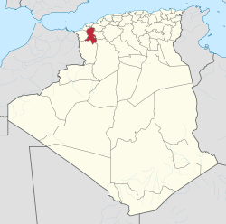
The province of Sidi Bel Abbès ( Arabic ولاية سيدي بلعباس, DMG Wilāyat Sīdī Bu-l-ʿAbbās , Central Atlas Tamazight ⴰⴳⴻⵣⴷⵓ ⵏ ⵙⵉⴷⵉ ⴱⴻⵍ ⵄⴻⴱⴱⴰⵙ Agezdu n Sidi bel Ɛebbas ) is a province ( wilaya ) in northwestern Algeria .
The province is located in the Tell Atlas near the Moroccan border, it includes the city of Sidi bel Abbès and its surrounding area and has an area of 8306 km².
Around 565,000 people (2006 estimate) inhabit the province, so the population density is around 68 inhabitants per square kilometer.
The province's economy is dominated by agriculture, mainly grain cultivation , in the town of Sidi bel Abbès itself there are also food processing and electronic industries.
Web links
Adrar | Ain Defla | Ain Temouchent | Algiers | Annaba | Batna | Bechar | Bejaia | Béni Abbès | Biskra | Blida | Bordj Badji Mokhtar | Bordj Bou Arreridj | Bouira | Boumerdes | Chlef | Constantine | Djanet | Djelfa | El Bayadh | El Meniaa | El M'Ghair | El Oued | El Tarf | Ghardaia | Guelma | Illizi | In Guezzam | In Salah | Jijel | Khenchela | Laghouat | Medea | Mila | Mostaganem | M'Sila | Muaskar | Naama | Oran | Ouargla | Ouled Djellal | Relizane | Saida | Sétif | Sidi Bel Abbès | Skikda | Souk Ahras | Tamanrasset | Tebessa | Tiaret | Timimoun | Tindūf | Tipasa | Tissemsilt | Tizi Ouzou | Tlemcen | Touggourt | Umm al-Bawāqī