
Annaba (province)
| Annaba | |
|---|---|
  |
|
| Basic data | |
| Country | Algeria |
| Capital | Annaba |
| surface | 1410 km² |
| Residents | 603,000 (2006 estimate) |
| density | 428 inhabitants per km² |
| ISO 3166-2 | DZ-23 |
Coordinates: 36 ° 52 ' N , 7 ° 36' E
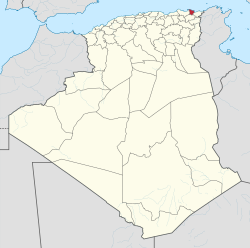
The province of Annaba ( Arabic ولاية عنابة, DMG Wilāyat ʿAnnāba , tamazight ⴰⴳⴻⵣⴷⵓ ⵏ ⵄⴻⵏⵏⴰⴱⴰ Agezdu n Ɛennaba ) is a province ( wilaya ) in northeastern Algeria .
The province is located on the Mediterranean Sea near the border with Tunisia , with an area of 1410 km² it is one of the country's smaller in area.
Around 603,000 people (2006 estimate) live in the province, so the population density is around 428 inhabitants per square kilometer.
The capital of the province is Annaba , other larger cities are El Bouni and Sidi Amar .
The province belonged to the Département de Constantine during the French colonial period . This belonged to French North Africa .
Web links
Adrar | Ain Defla | Ain Temouchent | Algiers | Annaba | Batna | Bechar | Bejaia | Béni Abbès | Biskra | Blida | Bordj Badji Mokhtar | Bordj Bou Arreridj | Bouira | Boumerdes | Chlef | Constantine | Djanet | Djelfa | El Bayadh | El Meniaa | El M'Ghair | El Oued | El Tarf | Ghardaia | Guelma | Illizi | In Guezzam | In Salah | Jijel | Khenchela | Laghouat | Medea | Mila | Mostaganem | M'Sila | Muaskar | Naama | Oran | Ouargla | Ouled Djellal | Relizane | Saida | Sétif | Sidi Bel Abbès | Skikda | Souk Ahras | Tamanrasset | Tebessa | Tiaret | Timimoun | Tindūf | Tipasa | Tissemsilt | Tizi Ouzou | Tlemcen | Touggourt | Umm al-Bawāqī