
Sodenberg
| Sodenberg | ||
|---|---|---|
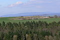
 The Sodenberg, Saale Valley with Untereschenbach and Diebach |
||
| height | 481.3 m above sea level NHN | |
| location | Bad Kissingen district , Bavaria ( Germany ) | |
| Mountains | Rhön | |
| Coordinates | 50 ° 6 '15 " N , 9 ° 48' 36" E | |
|
||
| Type | Chimney filling | |
| rock | basalt | |
| particularities | - Nature reserve 'Sodenberg-Gans' - formerly with Sodenberg Castle |
|

The Sodenberg ( 481.3 m above sea level , formerly Schottenberg or Kiliansberg) is a basalt cone on the banks of the Franconian Saale in the district of the city of Hammelburg in the Bavarian district of Bad Kissingen between the villages of Ochsenthal and Weickersgrüben. It forms the border between the wooded southern Rhön and the Franconian hill country. A large part of the mountain is part of the FFH - Sodenberg-Gans nature reserve .
The quarry , which has since been abandoned, can be seen as a special feature . In the first half of the 20th century basalt was extracted from the volcanic vent, so that the surrounding limestone now contains a crater with a diameter of about 150 meters, which corresponds roughly to the magma plug. According to ancient tradition, the original shape of the mountain resembled a sleeping lion, with the lion's head falling victim to basalt mining. With him disappeared the medieval castle ruin Sodenberg (Kilianstein), which used to be 506 m above sea level. NN high summit.
Starting from Gut Sodenberg, a hiking trail leads around the mountain, which leads past the crater and the former quarry area. On the way you can see relics of the quarry facilities such as a tunnel and wall remains. From the site of the former quarry there is a broad view to the north of the Saale and the Rhön with its basalt peaks.
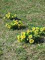
In the spring months, the mountain is a magnet for all flower lovers because of the abundance of springtime mugs , pasque flowers and adonis flowers .
Quarry and basalt works
The quarry was created in 1904 by the Leimbach & Co. company . Due to its convenient and central location on the Franconian Saale Valley Railway , it soon developed into the company's largest works. The area belonged to the Barons von Thüngen and had been leased by them for many years.
The basalt quarry was below the castle ruins that were still in existence at the time. A crusher building , a machine building for the steam engine with cooling tower needed to drive it, as well as a canteen and bedroom were built nearby . Up to 200 workers stayed in the building on weekdays. A cable car led from the crushing plant to the train station in Morlesau , with which all of the gravel was transported away.
The Jewish owners of the quarry lost their property through Aryanization in 1936 . He was taken over by the former technical director Hans Leimbach. After the Second World War, she paid 75,000 DM in reparation to Fritz Stein, one of the former owners. After Leimbach's death, the quarry was continued by his nephew Hermann Steinhard until 1958. At that time the pit had reached a depth of 70 m and it seemed too dangerous to continue mining because of the dangers of falling rocks.
A successor company wanted to extract gravel from the overburden, but had to give up after a short time due to financial difficulties. In the 1960s, Überlandwerk Unterfranken planned a pumped storage power plant with water from the Saale in the excavation pit. This could not be realized because the pit walls are too permeable to water.
Geotope
The Sodenberg basalt quarry has been identified as a valuable geotope by the Bavarian State Office for the Environment (geotope number: 672A001).
photos

The Sodenberg from Saaleck Castle
View over the summit to the Rhön Mountains
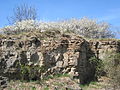
Old limestone quarry with a blooming sloe hedge
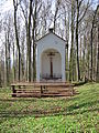
The Sodenberg Chapel on the edge of the crater

View into the "crater" (old basalt quarry)

Märzenbecher on Sodenberg

Märzenbecher on Sodenberg
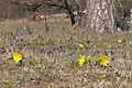
Adonis and Pasque Flowers on the Sodenberg
Adonis on the Sodenberg

Spring Adonis on Sodenberg


Web links
Individual evidence
- ↑ a b Map services of the Federal Agency for Nature Conservation ( information )
- ↑ 5824-302 "Sodenberg-Gans" nature reserve. (FFH area) Profiles of the Natura 2000 areas. Published by the Federal Agency for Nature Conservation . Retrieved November 28, 2017.
- ↑ a b c d Alfred Saam: The basalt works Oberriedenberg with its stone quarries Steinküppel, Gebirgsstein and Kellerstein , 1992, book in the University and State Library Fulda , p. 91/92
- ^ Bavarian State Office for the Environment, Geotop Former basalt quarry Sodenberg SW von Diebach (accessed on October 11, 2017).