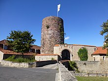
Saaleck Castle
The Saaleck Castle was created in the Middle Ages castle on an approximately 280 m high mountain ridge of Castle Hill ( 308 m above sea level. NHN ) in Hammelburg in the Bavarian district of Bad Kissingen . The only relic from the 12th – 13th centuries still visible today. Century is preserved in its original state keep . During the Thirty Years War it lost about six meters in height due to dilapidation. The appearance of the complex is mainly due to the time after the Thirty Years War.
history
Already in prehistoric times the mountain spur was used for fortifications, nothing of which has survived. A chapel is said to have been built there around 800. When the Rhön was Christianized , small chapels or churches were often built within "pagan" places of worship or fortifications. Examples are the Grabfeldonoburg near Münnerstadt or the Gangolfsberg near Oberelsbach .
However, the origins of the castle are still in the dark. It was first mentioned around 1030 by a historian of the nearby Homburg, which was greatly expanded at that time. It can be read that after the expansion, people “were waiting to stare at Trimburg and Saleck that they could never steal here!”
Major extensions were made in the 13th century. Abbot Heinrich von Erthal (1249–1261) completed the fortification and provided it with trenches, walls and battlements. The neck ditch was deepened and the shield wall reinforced. In the following centuries the castle was constantly being built. Even Ulrich von Hutten once paid 50 guilders for the renovation of a wooden bridge over the southern neck ditch.
The southernmost corner pillar of Fulda originally played an important role in this area. The castle was in a strategic place and was significantly strengthened at the time of Abbot Marquard I.
After the Thirty Years War , Salentin von Sintzig expanded the castle as a retirement home. According to him, the castle must have been in a very ruinous state at the time. Even the heaviest stones are said to have been removed by the population for their own building purposes. From 1644 to 1667 he had the entire complex rebuilt with the greatest care. Even before the Peasants' War , the complex had lost its military importance and had deteriorated into ruins. Until the Peasants' War, the castle had not suffered any major damage from wars or fires, which changed suddenly with the start of the war. The castle was occupied and devastated by the insurgents.
About 100 meters below the castle is the upper end of the Chapel Way of the Cross of the Old Town Monastery .
The castle or castle Saaleck is today protected as a landscape-defining architectural monument.
Todays use
On April 1, 1964, the city of Hammelburg took over Saaleck Castle and the associated wine-growing business in municipal ownership by a resolution of the city council . This ended the ongoing dispute about the existence of the palace complex. In October 2011 , the municipal winery went into private ownership. The new winery operates around 18 hectares of vineyards in the Saalecker Schlossberg and Hammelburger Heroldsberg sites and is expanding them in a cellar building next to the castle.
By October 2011, the town of Hammelburg with its managed house operation , the urban winery, vineyards in the layers Saalecker Schlossberg, Hammelburger Heroldsberg and Hammelburger Trautlestal vineyards with about 25 hectares. Extraordinary climatic conditions and limestone soils give the wines their special character and character. A hotel with a restaurant is operated in Saaleck Castle.
After extensive renovation, the 22 meter high keep has been accessible as a viewing tower since September 1998 and offers a very good view of the Saale valley and Hammelburg from its platform .
Web links
- Saaleck Castle
- Saaleck Castle on the homepage of the House of Bavarian History (plans, history, building history, building stock)
- Saaleck Castle at www.rhoenline.de
- Saaleck Castle winery
Individual evidence
- ↑ The top of the Schloßberg in the Bavaria Atlas, official map 1: 10,000
- ↑ List of monuments for Hammelburg (PDF) at the Bavarian State Office for Monument Preservation (PDF; 187 kB)
- ^ Photo of the information board on the tower, on commons.wikimedia.org
Coordinates: 50 ° 6 ′ 38.6 ″ N , 9 ° 52 ′ 19.5 ″ E


