Gangolfsberg (Rhoen)
| Gangolfsberg | ||
|---|---|---|
|
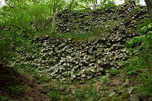
Basalt prismatic wall on the southeast slope of the Gangolfsberg |
||
| height | 735.8 m above sea level NHN | |
| location | near Oberelsbach ; District of Rhön-Grabfeld Bavaria ( Germany ) | |
| Mountains | Rhön | |
| Coordinates | 50 ° 27 '54 " N , 10 ° 5' 11" E | |
|
|
||
| Normal way | from the Schweinfurt house | |
| particularities | - Basalt prismatic wall - Teufelskeller (cave) - Gangolfsberg ramparts - St. Gangolf's chapel |
|
The Gangolfsberg is 735.8 m above sea level. NHN high mountain of the Rhön . It is located near Oberelsbach in the Bavarian district of Rhön-Grabfeld .
The mountain is best known for its basalt columns and prism walls. The remains of the Gangolfsberg ramparts are located on the summit region .
geography
location
The Gangolfsberg rises in the Bavarian Rhön Nature Park and in the Rhön Biosphere Reserve . Its summit is 3.4 km southwest of Roth vor der Rhön , 4.6 km southwest of Stetten , 5 km west of Sondheim vor der Rhön , 3.6 km west-northwest of Urspringen , 3.7 km northwest of Oberelsbach and 3.3 km north-northeast of Ginolfs . Beyond the Bavarian- Hessian border, 4.2 km away (as the crow flies ) , to which the landscape rises from the direction of the Gangolfsberg, is 7 km northwest of the desert Saxony .
About 2 km northeast of the summit is the Rother Kuppe ( 710.6 m ), 1.1 km east-southeast of the Hohe Rodkopf ( 607.1 m ), 1.5 km north-northwest of the Ilmenberg ( 787.1 m ). Past the mountain the Els flow in the southwest and the Zeeichenbolzenbach (Oberelsbachergraben) in the northeast.
geology
The steep drop of the southeast slope has one of the best preserved basalt prismatic walls in the Rhön; a path leads past there. The basalt columns have stood here obliquely to horizontally since the second uplift of the Rhön in the late Tertiary . Even the path fortifications and steps are made of basalt prisms. The basalt cave Teufelskeller is located about 250 m south-southwest of the summit .
Natural allocation
The Gangolfsberg belongs in the natural spatial main unit group Osthessisches Bergland (No. 35), in the main unit Hohe Rhön (354) and in the subunit Central Rhön (354.1) to the natural area Ostabfall der Langen Rhön (354.12).
Protected areas and geotopes

On the Gangolfsberg are part of the nature reserve Gangolfsberg ( CDDA -No 81711;. Reported in 1952, 1,826 square kilometers in size), the protected landscape Bavarian Rhon (CDDA No. 396113;. 959.8027 sq km) and the Fauna Flora Habitat type region Bavarian High Rhön (FFH no. 5526-371; 192.6059 km²) and the Elsbach natural forest reserve .
There are two geotopes on the mountain that have been designated by the Bavarian State Office for the Environment (LfU): The basalt prism wall on Gangolfsberg consists of stacked basalt columns with a diameter of 30 to 40 cm, one on top of the other: An information board is at the foot of the wall. The Teufelskeller on Gangolfsberg is a rock face with two basalt ceilings cut over a discordance . It has a natural cave (5m x 3m x 1.5m) under a huge fall block at the foot of the steep wall.
The mountain is mostly with deciduous mixed forest covers the basis of the geological basis of scree (gross Felszersatz) as scree forest is called, is its presence in the Rhön with the largest contiguous areas of this forest type in Central Europe.
Ramparts, chapel, desert areas, hikers' home
On the Gangolfsberg are the remains of the double gangolfsberg ramparts from Celtic to Merovingian times; Early medieval settlement is also assumed. The ruins of St. Gangolf's Chapel from the 8th century are on the northern part . The chapel dedicated to Saint Gangolf later gave the mountain its name. To the southeast lie the desert areas of Wermers (see Schweinfurt House ), Lahr and Lanzig . The Schweinfurt house (approx. 575 m ) is around 650 m east of the summit .
Individual evidence
- ↑ a b c Map services of the Federal Agency for Nature Conservation ( information )
- ↑ Brigitte Schwenzer: Geographical land survey: The natural space units on sheet 140 Schweinfurt. Federal Institute for Regional Studies, Bad Godesberg 1968. → Online map (PDF; 4.3 MB)
- ↑ Profile of the Elsbach natural forest reserve in the database of natural forest reserves in Germany of the Federal Agency for Agriculture and Food (BLE)
- ↑ Elsbach natural forest reserve (among others) in: Overview of natural forest reserves in Lower Franconia by the Bavarian State Institute for Forests and Forestry (LWF)
- ↑ Basalt prism wall on Gangolfsberg (Geotope no. 673A016), accessed on October 30, 2015, from lfu.bayern.de (PDF; 2.71 MB)
- ↑ Teufelskeller am Gangolfsberg (Geotope no. 673R003), accessed on October 30, 2015, from lfu.bayern.de (PDF; 3.24 MB)

