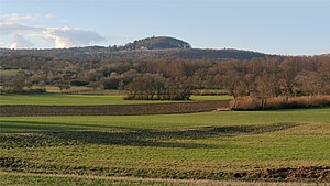
Rother summit
| Rother summit | ||
|---|---|---|
|
The Rother Kuppe seen from the southeast |
||
| height | 710.6 m above sea level NHN | |
| location | at Roth ; District of Rhön-Grabfeld , Bavaria ( Germany ) | |
| Mountains | Rhön ( Long Rhön ) | |
| Coordinates | 50 ° 28 '52 " N , 10 ° 6' 9" E | |
|
|
||
| Development | A cul-de-sac from district road NES 11 to the summit region | |
| particularities | Tower restaurant with observation tower | |
The Rother Kuppe is 710.6 m above sea level. NHN high mountain spur on the eastern slope of the Langen Rhön . It is located near Roth in the Bavarian district of Rhön-Grabfeld and is a trimmed basalt body on upper shell limestone . A tower restaurant with a lookout tower stands on the spur .
geography
location
The Rother Kuppe rises in the Bavarian Rhön Nature Park and the Rhön Biosphere Reserve . Its summit is 1.3 km southwest of the village of Roth , a south-western part of Hausen , 2.8 km west-south-west of Stetten , a northern part of Sondheim vor der Rhön , 4.3 km northwest of the Sondheim core town and 3.6 km northwest of the Community of Urspringen .
Natural allocation
The Rother Kuppe belongs to the natural spatial main unit group Osthessisches Bergland (No. 35), in the main unit Hohe Rhön (354) and in the subunit Central Rhön (354.1) to the natural area Ostabfall der Langen Rhön (354.12).
nature
Protected areas
On the Rother Kuppe are parts of the landscape protection area Bayerische Rhön ( CDDA -Nr. 396113; 959.8027 km² ). Parts of the fauna-flora-habitat area Bayerische Hohe Rhön (FFH-Nr. 5526-371; 192.6059 km²) and those of the bird sanctuary Bayerische Hohe Rhön (VSG-Nr. 5526-471; 190.2908 ) extend to their slopes km²).
Forest cover
The northeast flank of the mountain is forested, southwest of the summit there is a large meadow with old beeches, one of which is the thickest in the Rhön with a circumference of 7.8 m (waist). The tree, however, suffered a lot from Hurricane Kyrill ; some main branches broke off.
Tower restaurant with observation tower
The first wooden observation tower was built on the summit of the Rother Kuppe as early as 1890/1891 , which collapsed due to the rough weather in the Rhön in the years after the Second World War . The second wooden tower, which was inaugurated on May 15, 1955, defied the weather for only a few years and was demolished. In 1966/67 the third tower was erected, this time in reinforced concrete. This 21.5 m high Rother Kuppe observation tower is attached to the Rother Kuppe tower restaurant of the Rhön Club Nordheim, which was built in 1960 as a hiking home and is open all year round. From its viewing platform, a wide panoramic view of the Langen Rhön ( Heidelstein , Thuringian hut), the Thuringian Rhön ( Gebaberg , Dolmar , Hutsberg, Neuberg), the Thuringian Forest ( Großer Inselsberg ) and the Grabfeld ( Ostheim vor der Rhön , Gleichberge ) is possible .
Traffic and walking
Northwest past the Rother Kuppe, the NES 11 leads from Roth approximately westwards to the Hochrhönstraße as a winding county road. A short, steep driveway runs from this road to a car park located on the summit region. There are routes to the summit from the Schweinfurter Haus on Gangolfsberg and past the Thüringer Hütte, which is located on the eastern edge of the Lange Rhön nature reserve, 1.5 km west of the mountain spur .
Others
On the approximately 1000 m ENE located the Rother Kuppe Rother mountain near the county road NES 11 of Roth Rother towards tip 1893 is combined Justusbrunnen as a monument to the founder of Rhön clubs, Justus Schneider ; The Silbersee lies near the well in a former basalt quarry. The Rhön-Park-Hotel , which opened in 1975, is located on the south-eastern slope of the Rother Kuppe . Every last Sunday in June there is a mountain festival on the mountain spur.
See also
Web links
Individual evidence
- ↑ a b c Map services of the Federal Agency for Nature Conservation ( information )
- ↑ a b c d e f g The Rother Kuppe and surroundings , in: Sights of the community of Hausen , on hausen.rhoen-saale.net


