
Soeste
| Soeste | ||
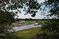
 The Soeste at Gut Stedingsmühlen |
||
| Data | ||
| Water code | DE : 3881 (i.e. upper reaches of 388) | |
| location | Germany , Lower Saxony | |
| River system | Ems | |
| Drain over | Nordloh-Barßeler Tief → Jümme → Leda → Ems → North Sea | |
| source | in the municipality of Emstek 52 ° 51 ′ 3 ″ N , 8 ° 10 ′ 24 ″ E |
|
| Source height | 53.5 m above sea level NHN | |
| muzzle | at Barßel association with Nordlohe-Barßeler Tief Coordinates: 53 ° 10 '33 " N , 7 ° 43' 37" E 53 ° 10 '33 " N , 7 ° 43' 37" E |
|
| Mouth height | approx. 1 m above sea level NHN | |
| Height difference | approx. 52.5 m | |
| Bottom slope | approx. 0.73 ‰ | |
| length | 71.7 km | |
| Catchment area | 457.45 km² | |
| Right tributaries | Lahe | |
| Reservoirs flowed through | Thülsfeld dam | |
| Medium-sized cities | Cloppenburg , Friesoythe | |
The Soeste (pronounced: Söhste ) is the left source river of the Jümme in Lower Saxony in the district of Cloppenburg .
course
The Soeste rises from a hollow on the eastern edge of the Schullenmoors in the north of Emstek . It flows north past the core town and is reinforced about 2 km west of the Emsteker Bäke coming from the town. In a north-westerly direction it reaches the outskirts of Cloppenburg , which it crosses in a south-westerly direction. There it already carries so much water that a water mill could previously be operated here, as evidenced by the name “Mühlenstraße” in the city center of Cloppenburg. The Soeste flows through two other former mill locations, Stedingsmühlen and Neumühlen, into the Thülsfeld dam , which was built in the 1920s. Shortly after it leaves the Geest area and flows through Friesoythe to Kampe, where right is her biggest tributary, the Lahe . Half a kilometer afterwards it is passed under the coastal canal with a culvert . Not far after that, the influence of the tides begins . united, and on to Barßel . On the last kilometer after the local boat harbor, it is somewhat widened and is probably also called "Zandersee" here.
At the confluence with the Nordloh-Barßeler Tief , the name and hydrographic definitions now differ from one another: The Soeste in particular ends here, while the deep is 3.2 km upstream from the Aue-Godensholter Tief and the Nordloher Canal . Hydrographically ( water code 388) it continues in the lower part of the deep and becomes 4.7 km further to the Jümme . Official maps from the 1980s also differentiated between the Nordloher Tief east of the confluence with the Soeste and the Barßeler Tief west of the confluence.

The Soeste in Cloppenburg
Inlet of the Soeste into the Thülsfeld dam
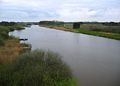
The Soeste in Barßel


literature
- Heinz-Josef Lücking: Ecological evaluation of the Soestetal between Cloppenburg and Stedingsmühlen (LK Cloppenburg, Northwest Germany) from the point of view of nature conservation: with special consideration of the vegetation, water quality and the ecomorphological water status . In: BSH / NVN - Nature Special Report / Biolog. Protection Association Hunte Weser-Ems; Nature Conservation Association of Lower Saxony . No. 21 . BSH-Verlag, Wardenburg 1995, ISBN 3-923788-29-0 .
Individual evidence
- ↑ Lower Saxony environmental maps with Layers GK 5 and water network
- ↑ Drawn GPS-Track Jümme - Soeste with intermediate notations when drawing; The OSM release of the Soeste also includes the lower part of the Nordloh-Barßeler Tief to the junction of the Dreyschloot
- ^ Environment Lower Saxony: Area directory Ems , including NRW rivers
- ^ Lower Saxony State Administration Office - State Surveying: Topographical Map 1: 100,000, Regional Map 2 North Oldenburg , 1986 edition