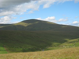
Sperrin Mountains
| Sperrin Mountains | ||
|---|---|---|
|
Sawel Mountain |
||
| Highest peak | Sawel Mountain ( 678 m ) | |
| location | Northern Ireland | |
|
|
||
| Coordinates | 54 ° 49 ′ N , 7 ° 2 ′ W | |
The Sperrin Mountains (for short Sperrins ; Irish Sliabh Speirín ) are a mountain region in Northern Ireland with elevations of over 670 m. They stretch between County Londonderry in the west and Lough Neagh in the east. At 678 m, the Sawel Mountain is the highest point in the Sperrins, which is a characteristic glacier landscape. Speirín stands for small mountain spur
The Sperrins are made up of slate , metamorphic rocks and quartzites . The original rocks, mostly limestone, sand and clay stones, were changed by the enormous heat and pressure of the mountain formation. The mountains were formed when the North American and Eurasian plates collided in the Ordovician , 440 to 500 million ago. The mountains themselves have eroded and only their roots - the metamorphic rocks at the core of what were once huge mountains - remained.
The region is the Area of Outstanding Natural Beauty . Ten kilometers north of Omagh , County Tyrone , in Gortin Glen, a popular hiking area, is the Ulster History Park open air museum . There are marked hiking trails through the forest and a nine-kilometer circular route by car. The approximately 1,534 hectare Gortin Glen Forest Park opened in 1967. The An Creagan Visitor Center and the Sperrin Heritage Center are located in Omagh. The stone circles of Beaghmore are 13.5 kilometers northwest of Cookstown in County Tyrone.
Web links
- The Sperrin Mountains at www.wandertipp.de (accessed April 30, 2011)
Individual evidence
- ↑ Ulster Place Names ( Memento of the original of September 28, 2011 in the Internet Archive ) Info: The archive link was automatically inserted and not yet checked. Please check the original and archive link according to the instructions and then remove this notice. (PDF file; 349 kB) - Magherafelt (C. Dunbar), accessed on April 30, 2011 (English)


