St Hilary
Coordinates: 50 ° 7 ′ N , 5 ° 25 ′ W
| St Hilary | |||
|---|---|---|---|
|
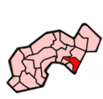
 Location in the former District of Penwith Location in the former District of Penwith
|
||
| Basic data | |||
| status | Civil Parish | ||
| region | South West England | ||
| Ceremony county | Cornwall | ||
| Trad. county | Cornwall | ||
| Administrative headquarters | St Hilary | ||
| Residents | 785 (2001) | ||
| Post Code | TR20 9xx | ||
| Telephone code | 01736 | ||
| Sub-locations | Relubbus , Kestal | ||
| Website | |||
St Hilary is a place and a civil parish in the former district of Penwith in the county of Cornwall in England . The local church, built in the perpendicular style , has a steeple from the 13th century. The rest of the church, badly damaged in a fire in 1853, was rebuilt in 1855 and constructed by William White . It is dedicated to Saint Hilary of Poitiers .
The community became well known in the 1930s when radical Protestants invaded the church and stole or destroyed the furnishings there. The local pastor Bernard Walke had the furniture installed beforehand.
Mining
Close to St Hilary are copper and tin mines such as the Penberthy Croft Mine, which mined copper-tin ores until 1840. This is the type locality of the rare mineral bayldonite .
Individual evidence
- ↑ Penberthy Croft Mine at mindat.org (English)

