Penwith
| Penwith District | |
|---|---|
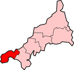
 Location in Cornwall |
|
| Basic data | |
| status | District |
| region | South West England |
| Administration County | Cornwall |
| Administrative headquarters | Penzance |
| surface | 303.56 km² (55.) |
| Residents | 65,000 (320.) |
| ONS code | 15UF |
| founding | 1974 |
| resolution | 2009 |


Penwith ( Cornish Pennwydh ) was a district of the county of Cornwall in England until March 31, 2009 . The name was derived from the Cornish words 'pen' ( headland ) and 'wyth' ( at the end ). It thus designates the southwestern tip of the island of Great Britain.
The administrative seat was the city of Penzance . The district was formed on April 1, 1974 and was formed from the merger of the boroughs of Penzance and St Ives, the urban district of St Just and the rural district of West Penwith. On April 1, 2009, in addition to Penwith, all other districts in Cornwall were abolished and combined into a single unitary authority.
Penwith has had a partnership with the German city of Cuxhaven since 1974 .
geography
The coastal landscape of Penwith is characterized by the rugged cliffs, which consist mainly of granite and slate , and the fine beaches that lie in between. Inland, a thin layer of soil covers the granite hilly landscape.
In the numerous depressions and valleys, thanks to the mild climate, subtropical plants and trees can also grow. In the Morrab Gardens of Penzance example, even grow bananas . Three kilometers west of Penzance is Penwith's only reservoir, the Drift Reservoir .
Apart from the south of the then district, the majority of the land mass was over 100 m above sea level. NN . Near Land's End , the westernmost point of England, copper and tin were already mined in pre-Roman times. Numerous ruins still bear witness to the time.
Significant places in the former District are Carbis Bay , Hayle , Lelant , Mousehole , Pendeen , Penzance , St Buryan , St Ives , St Just in Penwith and Zennor .
history
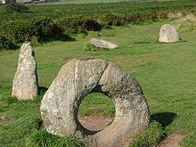
The Penwith area has a high density of archaeological sites. Well-known sites are Chûn Quoit , Lanyon Quoit or the Merry Maidens . The Iron Age and Romano-British time on are Fogous numerous. Fogous are Iron Age structures found in a similar form in the British Isles, including Ireland , and commonly referred to as the basement .
population
Of the 64,000 people living in Penwith, 96.4% were born in the UK. 72% of the population belong to Christianity , while 18% do not belong to any faith. Penwith has the sixth highest divorce rate in England and Wales at 13.4% and a correspondingly low percentage of married couples. Furthermore, unemployment is relatively high and medical care is poor compared to other districts.
Parishes
At the time of the dissolution of the district its territory encompassed 20 municipalities ( Parish )

|
economy
From an economic point of view, it is more difficult for Penwith than other districts in the economically weak county of Cornwall. The reasons for this are the poor school education of the rural population and the high youth unemployment. Traditionally, the region's economy is based on mining and fishing. Since most of the mines were closed in the last few decades, unemployment rose sharply.
Due to the newly created jobs in the growing tourism industry, unemployment hardly fell, as the majority of the population only finds employment there during the season.
Mining
Tin mining once played an important economic role in Penwith. Numerous pits in the St Just mining area such as the Levant Mine or the Botallack Mine are located in the district. The first resources were already exhausted during the 19th and 20th centuries. With the collapse of the worldwide tin cartel, the end of this industry was sealed. A chimney stands on Cape Cornwall as a memorial to this time, and the St Just mining area has been under special protection as a UNESCO World Heritage site since 2006.
The last mine in Penwith and Cornwall was at Geevor . Today it is, like the Levant Mine, a cultural monument and museum. The towns of St Just and Pendeen in particular have suffered from the collapse of the mining industry and the resulting unemployment.
fishing
Fishing is still an important source of income for Penwith today. In Newlyn , the largest deep-sea fishing port is in England. In 2004 it generated over 18 million pounds , which is over two percent of the regional gross domestic product . The port's trawlers are smaller compared to the Spanish and French factory vessels with which they share their fishing grounds. The foreign fishing fleets are also accused of illegally overfishing the sea and of causing local friction in the fishery. Large catches of sardines were made in Newlyn until the 1960s and were immediately processed there. For some years now, sardines have been increasingly fished again and sold to other southern European countries.
Agriculture
Many farmers in Penwith are under financial pressure due to the cut in subsidies for agriculture through the EU's Common Agricultural Policy . The foot and mouth disease in 2001 and pressure from supermarket chains also bothered some farmers. Agriculture lives mainly from dairy products as well as from individual crops such as potatoes, broccoli and cauliflower. Cornwall's mild climate means that potatoes and grain can be harvested earlier.
tourism
Popular places to visit in Penwith are the Minack Theater , the South West Coast Path and Land's End . Holidaymakers also like to visit the historic country houses, the Sennen Cove bathing beach and archaeological sites. In total, 19% of households in the district make a living from tourism.
traffic
As the westernmost point in the country and a small peninsula, Penwith is somewhat isolated from England. The main transport link is the A30 trunk road which runs from London to Land's End. The two railway lines, the St Ives Bay Line and the Cornish Main Line, are also important connections to the east. Helicopters and ferries depart from Penzance for the Isles of Scilly , 45 km southwest of Penwith.
See also
Web links
- Official website ( Memento of February 26, 2009 in the Internet Archive )
- Old postcards from Penwith
Individual evidence
- ^ The Electoral Cycle of the Town and Parish Councils in Penwith on the District's website ( Memento of February 17, 2005 in the Internet Archive )
Coordinates: 50 ° 10 ′ N , 5 ° 32 ′ W


