Steinenberg (Tübingen)
| Steinenberg | ||
|---|---|---|
|
View from the Steinenberg Tower over Tübingen in east to south-east direction to the Swabian Alb |
||
| height | 490.8 m above sea level NHN | |
| location | near Tübingen ; District of Tübingen , Baden-Württemberg ( Germany ) | |
| Mountains | Schönbuch | |
| Coordinates | 48 ° 31 '54 " N , 9 ° 1' 49" E | |
|
|
||
| particularities | Steinenberg Tower ( AT ) | |
|
Opened vineyard on the western slope of the Steinenberg |
||
The Steinenberg in Schönbuch is 490.8 m above sea level. NHN high mountain near Tübingen in the Baden-Württemberg district of Tübingen . The Steinenberg tower stands on its summit .
geography
location
The Steinenberg is the highest point of the Schönbuch trauf, about 2 km (as the crow flies ) northwest of the city center of Tübingen. On the eastern flank of the wooded mountain is, among other things, the professional association accident clinic Tübingen , and beyond the local Schnarrenbergstraße the landscape merges into the Schnarrenberg . In the north-west is the “Steinenberger Egert”, which was reforested with pines from 1857 to 1859.
Natural allocation
The Steinenberg belongs to the natural spatial main unit group Swabian Keuper-Lias-Land (No. 10), in the main unit Schönbuch and Glemswald (104) and in the subunit Schönbuch (104.1) to the natural area Tübingen step edge bay (104.10). Neighboring natural spaces that belong to the same subunit and are located near the mountains are: Walddorfer Platten (104.13) in the north and Südlicher Schönbuch (104.12) in the northwest.
geology
The geology of the Steinenberg is shaped by the Middle Keuper and in part by the Upper Keuper . In the upper part there are partially loess and loess clay toppings . The high areas are built up from marl and Rhätsandstein . The marl consists of an approximately 35 m thick, homogeneous layer of fine-grain marl of purple color. This is interspersed with carbonate, mostly dolomitic "tubers". The marl slopes are poorly suited as building ground due to the landslides of the clayey rock when wet. The fine pores of the claystone can absorb a great deal of water and thus increase their volume three times.
A closed 400 m long and up to 70 m wide slab made of Rhätsandstein is located above the easily eroded marl. This is morphologically very hard and therefore difficult to erode, so that a step formation occurs. In the process, boulders loosen from the boundary layer between Rhätsandstein and marl marl. These loosened stones gave the "Steinenberg" its name.
Agricultural use
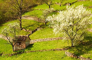
The southern slope of the Steinenberg was used as a vineyard by the Tübingen wine growers - the so-called Gôgen - until the beginning of the 20th century . The former cultivation areas are today orchards or are almost completely fallow due to the poor soil quality. However, the terracing of the slope caused by viticulture is still visible today.
Steinenberg Tower
On the Steinberg is since 1898 the observation tower Steinberg tower from which one south over Tübingen Swabian Mountains and north to the hills of the beautiful book can look.
See also
Individual evidence
- ↑ a b Map services of the Federal Agency for Nature Conservation ( information )
- ^ Friedrich Huttenlocher , Hansjörg Dongus : Geographical land survey: The natural spatial units on sheet 170 Stuttgart. Federal Institute for Regional Studies, Bad Godesberg 1949, revised 1967. → Online map (PDF; 4.0 MB)
- ^ A b Sonja Kay, Martin Rösler, Nadine Schmid and Dirk Sporleder: Mapping of the orchards on the Steinenberg. Retrieved January 6, 2017 . , As of June 30, 2005 (PDF; 1.7 MB)


