Steinheim (Memmingen)
|
Steinheim
City of Memmingen
Coordinates: 48 ° 0 ′ 55 ″ N , 10 ° 9 ′ 40 ″ E
|
|
|---|---|
| Height : | 585 m |
| Residents : | 2866 (Dec. 31, 2009) |
| Incorporation : | July 1, 1976 |
| Postal code : | 87700 |
| Area code : | 08331 |
|
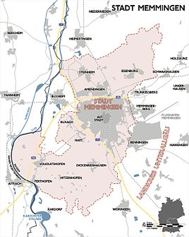
Location of Steinheim in Memmingen
|
|
Steinheim is a district and parish village of the Upper Swabian city of Memmingen .
geography
location
Steinheim is located about three kilometers north of the city center of Memmingen on the edge of the Memminger Achtal . In the west the place borders on the municipality of Buxheim and the state of Baden-Württemberg , in the north on the municipality Heimertingen , in the east on the district Eisenburg and in the south on the district Amendingen .
climate
Steinheim is at the average annual temperature and the amount of precipitation in the average zone of the temperate zone , whereby the precipitation is usually somewhat higher and the lowest temperatures somewhat lower. The coldest month is January with an average daily low temperature of −5 ° C and an average daily high temperature of 2 ° C. The warmest months are July and August with an average minimum temperature of 12 ° C and an average maximum temperature of 24 ° C.
history
The name Steinheim (in the Swabian dialect "Stoihoi"), which appears in the oldest property register of the Ottobeuren monastery , probably comes from a Roman milestone that protruded from the field on the old Roman road from Cambodunum to Kellmünz . The first traces of settlement can already be made out around 600 AD. The place was first mentioned in a document in 764. Since then the village has been owned by the Ottobeuren monastery . In the early 13th century the place came to the rule of Eisenburg as a fiefdom of the emperor . In 1448 the Unterhospitalstiftung Memmingen, which was subordinate to the city , bought him . Steinheim was thus in the possession of the free imperial city . The village was probably already a parish in 972 and became Evangelical Lutheran in 1525. The community received independence in 1803. It consisted of the main town and the districts of Egelsee and Steigmühle . On July 1, 1976, Steinheim was incorporated into the city as part of the municipal reform. Today Steinheim is a popular place for new buildings.
The tower of St. Martin's Church is high medieval. Construction of the nave began in 1764 and the building was inaugurated on June 29, 1765.
Culture and sights
Buildings worth seeing
The St. Martin's Church , the Steinheimer Schlössle, the old smithy and several old farms are all worth seeing . The old Zehntstadel is converted into a village community center.
societies
Club life and the village character are maintained in Steinheim. There is a band, a rifle club , a sports club, a volunteer fire brigade , a fruit and horticultural club , a warrior and soldier comradeship, a baseball team, choirs, a theater stage and church groups; In addition, the district fishing association is based in Steinheim. The Steinheim sports club was founded in 1947 with the soccer and heavy athletics departments and today has around 1000 members in six departments (popular sports, soccer, athletics, skiing, tennis and table tennis). He is a member of the Bavarian State Sports Association . The Steinheim music band was founded in 1888. She is a member of the Allgäu-Swabian Music Association and holder of the Pro-Musica badge . The band consists of around 50 members. Every year the Steinheim associations organize the Maypole Festival on May 1st and the Steinheim Village Festival in summer. Six associations have joined together to form the Steinheim Maypole Association.
Web links
Individual evidence
- ↑ Kgl. Statistical Bureau (ed.): Complete list of localities of the Kingdom of Bavaria. According to districts, administrative districts, court districts and municipalities, including parish, school and post office affiliation ... with an alphabetical general register containing the population according to the results of the census of December 1, 1875 . Adolf Ackermann, Munich 1877, 2nd section (population figures from 1871, cattle figures from 1873), Sp. 1466 , urn : nbn: de: bvb: 12-bsb00052489-4 ( digitized ).
- ^ Bavarian State Statistical Office (ed.): Official place directory for Bavaria . Issue 335 of the articles on Bavaria's statistics. Munich 1973, DNB 740801384 , p. 221 ( digitized version ).
- ^ Federal Statistical Office (ed.): Historical municipality directory for the Federal Republic of Germany. Name, border and key number changes in municipalities, counties and administrative districts from May 27, 1970 to December 31, 1982 . W. Kohlhammer GmbH, Stuttgart and Mainz 1983, ISBN 3-17-003263-1 , p. 764 .
- ↑ As of 2011, website of the music band


