Stellberg (Melpers)
| Stellberg | ||
|---|---|---|
|
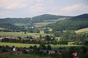
View from the area southwest of Fladungen northwards to the Stellberg near Melpers |
||
| height | 662.3 m above sea level NHN | |
| location | at Melpers ; District of Schmalkalden-Meiningen , Thuringia ( Germany ) | |
| Coordinates | 50 ° 33 '32 " N , 10 ° 8' 27" E | |
|
|
||
The Stellberg is 662.3 m above sea level. NHN high mountain of the Vorder- and Kuppenrhön . It is located near Melpers in the Thuringian district of Schmalkalden-Meiningen ( Germany ).
geography
location
The Stellberg rises 1 km east of the border between Thuringia (district of Schmalkalden-Meiningen) and Bavaria ( district of Rhön-Grabfeld ). Its summit is 1.1 km north of Melpers , 2.8 km south-southeast of Reichenhausen , 1.8 km south of Erbenhausen and 2.5 km southwest of Schafhausen . The federal road 285 runs over its western and southern slopes between Melpers and Reichenhausen .
Natural allocation
The Stellberg belongs to the natural spatial main unit group Osthessisches Bergland (No. 35), in the main unit Vorder- und Kuppenrhön (353) and in the subunit Kuppenrhön (353.2) to the natural area Auersberger Kuppenrhön (353.24). To the south, the landscape falls into the subunit Eastern Rhön foreland (353.3).
Rhine-Weser watershed
The Rhine-Weser watershed runs over the Stellberg . The water of the streu flowing southwest past the mountain reaches the Rhine through the Franconian Saale and the Main . That of the Felda , which rises north-northeast of the mountain , reaches the Weser through the Werra .
Protected areas
Parts of the Thuringian Rhön landscape protection area are located on the Stellberg ( CDDA no. 20897; designated in 1989; 63.189 km² in size). Parts of the fauna-flora-habitat area Hohe Rhön (FFH no. 5426-320; 16.2 km²) extend up to its western flank, and parts of the Thuringian Rhön bird sanctuary (VSG no. 5326- 401; 199.49 km²).

