
Steppach near Augsburg
|
Steppach near Augsburg
City of Neusäß
|
|
|---|---|
_COA.svg) |
|
| Residents : | 4011 (2011) |
| Incorporation : | May 1, 1978 |
| Postal code : | 86356 |
| Area code : | 0821 |
 Map of Neusäß with its districts
|
|
 Steppacher triangle
|
|
Steppach near Augsburg (officially Steppach b.Augsburg ) is a parish village and district of the city Neusäß in the Swabian district of Augsburg in Bavaria ( Germany ). The parish village and the eastern part of the village of Vogelsang are located in the district of the same name . The western part of Vogelsang belongs to the municipality of Diedorf .
history
Steppach was probably founded around the year 1000.
A peculiarity of the population development of Steppach was the blossoming of a Jewish community . After 1438 the Jews were no longer tolerated in the imperial city of Augsburg and found an opportunity to exist in the surrounding area. They were mainly active in trade, as they were not permitted to trade or trade. From 1584 to the end of the 19th century, a quarter to a third of Steppach's inhabitants were Jewish. In the “Alte Reichsstraße” there were not only several “ communal houses ” (corresponding to today's condominiums), but also a synagogue and a ritual immersion bath ( mikveh ). From the middle of the 19th century, the Jewish population began to emigrate, and in 1910 there were no longer any Jews living there.
In the course of time, the center of the town shifted from the old village center on the Alte Reichsstraße to the new Ulmer Straße. Due to a renovation measure, the street was rebuilt and given a small square, the so-called Steppacher triangle , to which a few shops and high-rise buildings are lined up.
Former parish
Until about 1960 the place and community name was "Steppach", without the addition "b.Augsburg".
The area of the former municipality was about 247 hectares . The part of the municipality Vogelsang appears for the first time in the results of the 1950 census, when the part name was not yet officially assigned. On May 1, 1978, the municipality lost its independence in the course of the regional reform in Bavaria and was incorporated into Neusäß.
Population development
| Parish village | local community | |
|---|---|---|
| 1840: | 589 inhabitants | |
| 1861: | 535 inhabitants | 535 inhabitants |
| 1867: | 538 inhabitants | |
| 1871: | 532 inhabitants | 532 inhabitants |
| 1875: | 568 inhabitants | 568 inhabitants |
| 1885: | 596 inhabitants | 596 inhabitants |
| 1900: | 604 inhabitants | 604 inhabitants |
| 1925: | 719 inhabitants | 719 inhabitants |
| 1950: | 1664 inhabitants | 1818 inhabitants |
| 1961: | 1812 inhabitants | 2053 inhabitants |
| 1970: | 2613 inhabitants | 2815 inhabitants |
| 1987: | 3320 inhabitants |
religion
In 1150 there is the oldest documented mention of a church in Steppach, which came to the St. Moritz Collegiate Church in Augsburg at around the same time . The church was incorporated there in 1431 . The Church of St. Gallus was rebuilt and consecrated in 1626 after it collapsed in 1623. An independent Catholic parish in Steppach was established in 1753. In 1866, the parish church of St. Gallus was expanded to include a window axis to make room for the growing community.
The synagogue in Steppach was built around 1700 and expanded in 1753. When Steppach's Jewish community was incorporated into the Augsburg religious community in 1873, this church was no longer in use. It was sold and probably demolished at the end of the 19th century.
The Catholic parish church of Saint Raphael was built in 1981 and consecrated in 1983. The parish Sankt Raphael in Steppach belongs to the deanery Augsburg-Land in the diocese of Augsburg .
Attractions
The Augsburg Bismarck Tower and a Gallus Church are located near Steppach .

The Bismarck Tower
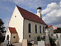
The parish church of St. Gallus

.JPG)
Personalities
- Albrecht Gerstle (* 1842 in Steppach; † 1921 in Memmingen), banker and board member of the Jewish community in Memmingen
Web links
- City of Neusäß, official homepage
- Steppach near Augsburg in the location database of the Bavarian State Library Online . Bavarian State Library
- Action group Steppach
Individual evidence
- ↑ a b c d Bavarian State Statistical Office (Hrsg.): Official place directory for Bavaria - edited on the basis of the census of September 13, 1950 . Issue 169 of the articles on Bavaria's statistics. Munich 1952, DNB 453660975 , Section II, Sp. 1260 ( digitized version ).
- ↑ a b Bavarian State Statistical Office (ed.): Official city directory for Bavaria, territorial status on October 1, 1964 with statistical information from the 1961 census . Issue 260 of the articles on Bavaria's statistics. Munich 1964, DNB 453660959 , Section II, Sp. 920 ( digitized version ).
- ↑ a b K. Bayer. Statistical Bureau (Ed.): Localities directory of the Kingdom of Bavaria. According to government districts, administrative districts, ... then with an alphabetical register of locations, including the property and the responsible administrative district for each location. LIV. Issue of the contributions to the statistics of the Kingdom of Bavaria. Munich 1888, Section III, Sp. 1321 ( digitized version ).
- ↑ Bavarian State Office for Statistics and Data Processing (Hrsg.): The municipalities of Bavaria according to the territorial status May 25, 1987. The population of the municipalities of Bavaria and the changes in the acquisitions and territory from 1840 to 1987 (= contributions to Statistics Bavaria . Issue 451). Munich 1991, p. 123 , urn : nbn: de: bvb: 12-bsb00070717-7 ( digitized version - footnote 22).
- ↑ Bavarian State Statistical Office (Hrsg.): Historical municipality register: The population of the municipalities of Bavaria in the period from 1840 to 1952 (= contributions to Statistics Bavaria . Issue 192). Munich 1954, DNB 451478568 , p. 221 , urn : nbn: de: bvb: 12-bsb00066439-3 ( digital copy ).
- ^ Joseph Heyberger, Chr. Schmitt, v. Wachter: Topographical-statistical manual of the Kingdom of Bavaria with an alphabetical local dictionary . In: K. Bayer. Statistical Bureau (Ed.): Bavaria. Regional and folklore of the Kingdom of Bavaria . tape 5 . Literary and artistic establishment of the JG Cotta'schen Buchhandlung, Munich 1867, Sp. 1264 , urn : nbn: de: bvb: 12-bsb10374496-4 ( digital copy ).
- ↑ Kgl. Statistisches Bureau (Ed.): Directory of the municipalities of the Kingdom of Bavaria according to the status of the population in December 1867 . XXI. Issue of the contributions to the statistics of the Kingdom of Bavaria. Ackermann, Munich 1869, p. 206 ( digitized version ).
- ↑ Kgl. Statistical Bureau (ed.): Complete list of localities of the Kingdom of Bavaria. According to districts, administrative districts, court districts and municipalities, including parish, school and post office affiliation ... with an alphabetical general register containing the population according to the results of the census of December 1, 1875 . Adolf Ackermann, Munich 1877, 2nd section (population figures from 1871, cattle figures from 1873), Sp. 1384 , urn : nbn: de: bvb: 12-bsb00052489-4 ( digital copy ).
- ↑ Kgl. Statistical Bureau (ed.): Complete list of localities of the Kingdom of Bavaria. According to districts, administrative districts, court districts and municipalities, including parish, school and post office affiliation ... with an alphabetical general register containing the population according to the results of the census of December 1, 1875 . Adolf Ackermann, Munich 1877, section 3, p. 150 , urn : nbn: de: bvb: 12-bsb00052489-4 ( digital copy ).
- ↑ K. Bayer. Statistical Bureau (Ed.): Directory of localities of the Kingdom of Bavaria, with alphabetical register of places . LXV. Issue of the contributions to the statistics of the Kingdom of Bavaria. Munich 1904, Section II, Sp. 1407 ( digitized version ).
- ↑ Bavarian State Statistical Office (ed.): Localities directory for the Free State of Bavaria according to the census of June 16, 1925 and the territorial status of January 1, 1928 . Issue 109 of the articles on Bavaria's statistics. Munich 1928, Section II, Sp. 1442 ( digitized version ).
- ^ Bavarian State Statistical Office (ed.): Official place directory for Bavaria . Issue 335 of the articles on Bavaria's statistics. Munich 1973, DNB 740801384 , p. 201 ( digitized version ).
- ↑ Bavarian State Office for Statistics and Data Processing (Ed.): Official local directory for Bavaria, territorial status: May 25, 1987 . Issue 450 of the articles on Bavaria's statistics. Munich November 1991, DNB 94240937X , p. 392 ( digitized version ).
- ^ Church of St. Gallus - Parish Community Am Kobel. In: pg-am-kobel.de. Retrieved on February 18, 2019 (German).
- ^ The synagogue in Steppach (City of Neusäß, District of Augsburg). In: alemannia-judaica.de. www.alemannia-judaica.de, accessed on February 18, 2019 .
- ↑ Parish Church of St. Raphael - Parish Community Am Kobel. In: pg-am-kobel.de. Retrieved on February 18, 2019 (German).
- ↑ Archived copy ( memento of the original from January 14, 2017 in the Internet Archive ) Info: The archive link was inserted automatically and has not yet been checked. Please check the original and archive link according to the instructions and then remove this notice.
