
Westheim near Augsburg
|
Westheim near Augsburg
City of Neusäß
|
|
|---|---|
_COA.svg) |
|
| Height : | 486 m above sea level NN |
| Residents : | 3216 (1987) |
| Incorporation : | July 1, 1972 |
| Postal code : | 86356 |
| Area code : | 0821 |
 Map of Neusäß with its districts
|
|
 Former New Castle, now Notburgaheim
|
|
Westheim bei Augsburg (officially Westheim b.Augsburg ) is a parish village and district of the city Neusäß in the Swabian district of Augsburg in Bavaria , Germany with about 3,200 inhabitants.
history
In antiquity the Roman road Augsburg - Günzburg ran through the Westheimer Flur . A Roman state pottery from the 2nd century was found east of the Westheim cemetery from 1852 to 1854 during the construction of the railway line .
Today's Westheim is likely to have been founded around the 11th century. The place name is said to go back to the castle of a family de Westhain in the 13th century. According to a chronic tradition, the moated castle is said to have existed as early as 1160. The Burgstall Kobel , also located in Westheim, was probably in the 11th / 12th. Century built with a small tower hill castle (Motte). Westheim is first mentioned in a document in 1234.
The Augsburg patrician family von Langenmantel (the branch "Langenmantel zum RR") were the local lords of Westheim from the Middle Ages to the 19th century . The double R from their family coat of arms is still included in the coat of arms of Westheim and also in the city coat of arms of Neusäß. The von Langenmantel family had jurisdiction over the lower courts and ran blacksmiths, mills, taverns, inns and bath houses. Since 1648 they were also the local lords in Hirblingen and Neusäß . The line of Langenmantel "von Westheim" goes back to Wolfgang von Langenmantel (II, † 1568). The castle in Westheim was converted into a palace by the von Langenmantel family. In 1806, as a result of secularization, the area of the Augsburg bishopric , and with it Westheim, fell to Bavaria . This was the beginning of the municipality's self-government. In 1837 the Langenmantel family sold the Westheimer Schloss. In 1927 a retirement home for Catholic domestic workers was set up there. From this old people's home, today's “Notburgaheim”, enlarged by several buildings, arose.
In 1854 Westheim was connected to the Bavarian Maximiliansbahn (the Augsburg – Ulm line ). In 1892, this line was expanded to two tracks, which further improved the connection to Augsburg. At the beginning of the 20th century, Westheim was booming as a villa colony . Wealthy citizens built stately villas (some of which were initially only inhabited in summer) on the slopes of the Kobel. While the "old" Westheim is located northwest of the railway line, the place expanded to the area southeast of the railway line. The station building, the first town hall, the first school and the first churches were built here.
A Kurhaus built around 1905 in Westheim, where the doctor Dr. Voigt carried out water cures according to Sebastian Kneipp's apprenticeship , can be seen on old postcards of the place. It was operated until the First World War. In 1927 it was bought by the "Association of Parsonage Employees of the Diocese of Augsburg", renovated and added a house chapel. From 1929 the Kurhaus served as a priest home for retired clergy. Today it is a private house in the street "Am Kurhaus"; the house chapel was demolished.
The first school in Westheim was built in 1890. In 1957 a new elementary school was built, which still exists today, and the old one was abandoned. In 1974 the school was expanded to include a gym.
In 1911 the electrification of Westheim began. In 1912 a water supply was created that also supplied the communities of Westheim and Steppach with a water tower on the highest point of the Kobelberg.
Westheim was an independent municipality as Westheim bei Augsburg , was incorporated into Neusäß on July 1, 1972 as part of the regional reform in Bavaria and is now the third largest district of Neusäß.

Kobelberg
The district of Westheim includes the 525 m high Kobelberg (also just called the Kobel ), which, as far as its forest allows it, offers a good view of Augsburg and the Schmuttertal. In the Middle Ages there was here a Turmhügelburg (moth), of the still part Burgstall as ground monument is preserved. In 1602 the pilgrimage chapel of St. Mary of Loreto was built about 200 m from the castle stables , which was expanded into a pilgrimage church in the 17th and 18th centuries. The Kobel is forested (" Kobelwald ") and connects Westheim with Steppach .

Next to the Kobel Church there was a restaurant for the pilgrims' food for a long time. In 1898 this Kobel inn, the “Gasthof zum Kobel”, was expanded into a spacious restaurant with a hall, stage and observation tower. Old postcards are still reminiscent of this inn, which was a popular excursion destination at the turn of the century. It was demolished in 1969.
In 1931 an 18 meter metal cross was erected on the Kobel with a view of Augsburg, the “Kobel Cross”. On its pedestal is the inscription "Honor Christ, love Mary - the holy mountain as a sign".
In 1937 a way of the cross for the pilgrims was added on the western slope of the Kobel . The 14 carved wood works by the sculptor Josef Beyrer were released during a restoration carried out in Augsburg Cathedral in 1934 . The first twelve stations were housed in four chapels along a way of the cross on the slope of the Kobel. Each of these four chapels, which were made by Anton Kinseher (1936/37), contains a wayside shrine with three stations each. The 13th and 14th stations are located on the garden wall of the Benefiziatenhaus.
In 1954 the Kobelwald was declared a landscape protection area.
Since 1973 there has been a privately operated weather station on the Kobel , at which temperature, rainfall and humidity are measured according to official specifications; since 2013 also air pressure, solar radiation and wind. In June 2013, a tornado devastated the Kobel Forest and destroyed around 80% of its tree population. Reforestation began in 2014.

The Kobel castle stable
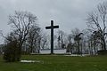
The Kobel Cross

Way of the Cross chapel

The Adalbert Stifter memorial stone on the Kobel


Pilgrimage church on the Kobel

On the Kobelberg is the curate and pilgrimage church of St. Maria von Loreto , also called the Kobelkirche , which was built in 1602 .

Engraving from Kobelberg, 1720
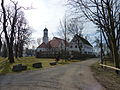
Exterior view

inside view

Miraculous image


religion
The oldest chapel in Westheim, the former castle chapel "Sankt Cosmas und Damian", was built in 1587 and expanded in 1777. It contains five sandstone figures from around 1730/1740 and is located in the garden of today's Notburgaheim.
Westheim did not have its own Roman Catholic parish church for a long time , because the Kobel Church was and is only a pilgrimage church to this day. In the absence of its own parish, Westheim belonged to the parish of St. Stephanus in Hainhofen until 1947 . The Kobel Church (supported by the Catholic Von Langenmantelschen Kobelkapellenstiftung ) also belonged to this Hainhofen parish until 1947, and since then to the parish of St. Nicholas of Flüe.
The Evangelical Philippus Congregation built the Philippuskirche in Westheim in 1928. It belongs to the deanery Augsburg in the parish of Augsburg .
The Catholic parish Sankt Nikolaus von Flüe , founded in Westheim in 1947, belongs to the dean's office Augsburg-Land in the diocese of Augsburg . The parish church of St. Nikolaus von Flüe was built in 1961/62.
A congregation of the New Apostolic Church has existed in Westheim since 1947. In 1975 the New Apostolic congregation also built a church in Westheim.

The chapel "Saint Cosmas and Damian"

The Evangelical Philip Church

The Catholic parish church of St. Nicholas of Flüe

The New Apostolic Church


Infrastructure
.jpg)
Westheim borders on the city of Augsburg in the east, in the immediate vicinity of the Augsburg District Hospital and the Augsburg University Hospital .
Westheim has its own passenger station, Westheimer Bahnhof, on the Augsburg – Ulm railway line . The train station in Westheim is called Westheim (Schwab) .
In 2001, Neusäß received its own connection to the Federal Motorway 8 . The Federal Highway 10 (formerly National Highway 10) begins (or ends) in Neusäß. The street name Alte Reichsstraße in Steppach still reminds of them. The federal highway 300 now leads past Neusäß to the south as a bypass .
Personalities
- Joseph Molitor von Mühlfeld (* 1855 at Westheim Palace; † 1890 in Munich), painter
- Hans Rost (* 1877 in Bamberg, † 1970 in Westheim), journalist and suicide researcher
- Martha Schad (* 1939 in Munich, lives in Westheim), historian and author
- Christoph Stölzl (* 1944 in Westheim), historian, museologist and CDU politician
literature
- City of Neusäß: Westheim. A place through the ages. context Verlag Augsburg , 2015, ISBN 978-3-939645-86-3
Web links
- City of Neusäß, official homepage
- Westheim near Augsburg in the location database of the Bayerische Landesbibliothek Online . Bavarian State Library
- Curate and pilgrimage church of St. Maria Loreto
Individual evidence
- ↑ The parish introduces itself (PDF)
- ^ History of the coat of arms of the city of Neusäß
- ↑ Westheim ( Memento of the original from February 3, 2015 in the Internet Archive ) Info: The archive link was automatically inserted and not yet checked. Please check the original and archive link according to the instructions and then remove this notice. on www.neusaess-kompakt.de
- ^ Wilhelm Volkert (ed.): Handbook of Bavarian offices, communities and courts 1799–1980 . CH Beck, Munich 1983, ISBN 3-406-09669-7 , p. 424 .
- ↑ kobelschutzverein.de
- ↑ kobelschutzverein.de
- ↑ Mini-tornado hits weather experts , Augsburger Allgemeine from June 22, 2013
- ↑ The old Kobelwald ends in fire , Augsburger Allgemeine from December 3, 2013
- ↑ New forest for Neusäß ( Memento of the original from February 2, 2015 in the Internet Archive ) Info: The archive link was automatically inserted and not yet checked. Please check the original and archive link according to the instructions and then remove this notice. , City newspaper from June 19, 2014
- ↑ Worth seeing. (No longer available online.) Formerly in the original ; Retrieved February 7, 2015 . ( Page no longer available , search in web archives ) Info: The link was automatically marked as defective. Please check the link according to the instructions and then remove this notice.
