Stewart River (Yukon River)
| Stewart River | ||
|
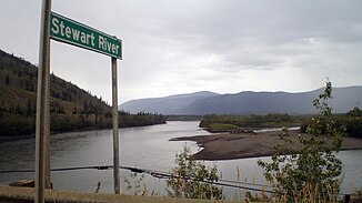
View from the Klondike Highway over the Stewart River |
||
| Data | ||
| location | Yukon ( Canada ) | |
| River system | Yukon River | |
| Drain over | Yukon River → Bering Sea | |
| source | in the Selwyn Mountains 64 ° 6 ′ 2 ″ N , 131 ° 43 ′ 49 ″ W |
|
| muzzle | at the town of Stewart River in the Yukon River coordinates: 63 ° 17 ′ 30 " N , 139 ° 24 ′ 42" W 63 ° 17 ′ 30 " N , 139 ° 24 ′ 42" W
|
|
| length | 644 km | |
| Catchment area | 51,000 km² | |
| Discharge at the gauge above Fraser Falls A Eo : 30,600 km² |
MQ 1980/1995 Mq 1980/1995 |
374 m³ / s 12.2 l / (s km²) |
| Discharge at the Mayo A Eo gauge : 31,600 km² |
MQ 1949/1979 Mq 1949/1979 |
369 m³ / s 11.7 l / (s km²) |
| Discharge at the Stewart Crossing A Eo gauge : 35,000 km² |
MQ 1961/1973 Mq 1961/1973 |
414 m³ / s 11.8 l / (s km²) |
| Discharge at the gauge at the mouth of the A Eo : 51,000 km² |
MQ 1963/2000 Mq 1963/2000 |
463 m³ / s 9.1 l / (s km²) |
| Left tributaries | Lansing River , Hess River | |
| Right tributaries | Beaver River , Nadaleen River , Mayo River , McQuesten River | |
| Communities | Mayo , Stewart Crossing , Stewart River | |
|
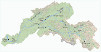
Stewart River in the Yukon River basin |
||
The Stewart River is a 644 km long river in the Territory Yukon in Canada .
It originated in the Selwyn Mountains near the border between the Northwest Territories and the Yukon. From there the Stewart River flows west, past the town of Mayo . The river crosses the Klondike Highway at Stewart Crossing . The highway then runs parallel to the river in a westerly direction for about 50 km. Then the river turns southwest until it meets the Yukon River 112 km south of Dawson . The essentially abandoned town of Stewart River is located at the confluence with the Yukon River.
The Stewart River was explored in 1850 by Robert Campbell of the Hudson's Bay Company . He named the river after a friend. The area remained largely untouched until the start of the Klondike gold rush when it was opened to gold diggers.
Web links
Individual evidence
- ^ A b The Atlas of Canada - Rivers
- ↑ Stewart River at the gauge above Fraser Falls - hydrographic data from R-ArcticNET
- ↑ Stewart River at the Mayo gauge - hydrographic data from R-ArcticNET
- ↑ Stewart River at the Stewart Crossing gauge - hydrographic data from R-ArcticNET
- ↑ Stewart River at the gauge at the mouth - hydrographic data from R-ArcticNET
- ^ Natural Resources Canada. "Stewart River" ( Memento of the original from June 8, 2011 in the Internet Archive ) Info: The archive link was inserted automatically and has not yet been checked. Please check the original and archive link according to the instructions and then remove this notice. , Geographic Names of Canada. Accessed May 13, 2009.
- ^ Webb, Melody. Yukon: The Last Frontier UBC Press, 1993. p. 39.

