Stockum / Düren
|
Stockum / Düren
City of Witten
Coordinates: 51 ° 28 ′ 17 ″ N , 7 ° 21 ′ 54 ″ E
|
|
|---|---|
| Height : | 158 m above sea level NN |
| Area : | 5.43 km² |
| Residents : | 6275 (Dec. 31, 2018) |
| Population density : | 1,155 inhabitants / km² |
| Postal code : | 58454 |
| Area code : | 02302 |
|
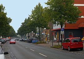
Hörder Straße , the main thoroughfare in Stockum
|
|
Stockum / Düren is one of the seven districts of Witten .
Stockum / Düren borders on Annen and Mitte in Witten , on Oespel , Kley and Salingen in Dortmund and on Langendreer in Bochum . The former communities of Stockum and Düren have belonged to Witten since 1929, and before that they belonged to the Langendreer district .
history
The first recorded mention of Stockum dates back to the year 882. In the Werdener Urbar a place called villa stochem is mentioned, in which taxable free farmers from the Brukterergau have settled. In documents from Siegburg Abbey from 1096, it is noted that Archbishop Hermann von Köln donated several farms in Stockum to the monastery. Several of these courtyards were located in the area that today represents the Düren district. When Düren was first named separately as Düren is disputed. Recently a certificate from Emperor Otto III. from 997, issued in ture , related to Düren.
From 1850 to 1929 Stockum and Düren belonged to the office of Langendreer , in the course of a community reform Stockum and Düren became districts of Witten on August 1, 1929.
Ecclesiastically , Stockum-Düren has belonged to the parish of Lütgendortmund since the turn of the millennium and only became an independent parish in 1906, although it had its own cemetery since 1855 and the Protestant church was inaugurated in 1902 .
Stockum and Düren were separate districts until 2013, when they were combined into a single district. The subdivision into statistical districts was not changed.
Statistical districts
The district consists of the following statistical districts (with their population as of December 31, 2018):
| No. | Statistical district | Pop. |
|---|---|---|
| 21st | Düren-North | 272 |
| 22nd | Düren-South | 80 |
| 31 | Stockum center | 4111 |
| 32 | Dorney | 404 |
| 33 | Stockumer break | 337 |
| 34 | Wilhelmshöhe | 1071 |
Individual evidence
- ↑ Statistical Yearbook 2018 (PDF; 8.2 MB) In: Witten.de. P. 7 , accessed on May 16, 2019 .
- ↑ Population in the districts. (PDF; 80.6 kB) In: Witten.de. December 31, 2018, accessed May 16, 2019 .
- ^ Book about noble families. In: Kölner Rundschau , May 20, 2011; Retrieved April 27, 2017.
- ↑ Stephanie Reekers: The regional development of the districts and communities of Westphalia 1817-1967 . Aschendorff, Münster Westfalen 1977, ISBN 3-402-05875-8 , p. 297 .
- ↑ Population in the statistical districts. (PDF; 30.2 kB) In: Witten.de. December 31, 2018, accessed May 16, 2019 .

