Dash path
The Strichweg in Cuxhaven - Döse is an approx. 1.9 km long road. It leads in an east-west direction parallel to the North Sea / Elbe dike from Marienstraße / Catharinenstraße through the Lotsen- and then the Afrikaviertel to Stickenbütteler Weg / Bei der Kirche and Steinmarner Straße and to Duhnen .
Back streets
The side and connecting streets were named as Marienstraße after the first name of the wife of the mayor Johann Paul Siats, Catharinenstraße 1892 after the first names of the women of the two builders of the street, Bernhardstraße after the son Bernhard of the Döser farmer and community leader Peter Künnmann, Batteriestraße after the battery the artillery of Fort Grimmerhörn (around 1870), Deichtrift after Trift as the driving of cattle, Lichtenbergplatz 1954 after the Göttingen physicist Georg Christoph Lichtenberg (1742–1799), Hermann-Allmers-Straße 1945 after the marching poet Hermann Allmers (1821–1902) , Dohrmannstraße after the entrepreneur and initiator of the Duhner Wattrennens Robert Dohrmann (1850–1932), Jänischstraße 1925 after the bailiff Johann Joachim Jänisch, Wißmannstraße 1936 after the Africa explorer and governor of the German East Africa colony Hermann von Wissmann (1853–1905), Adolfstraße 1905 after the farmer Adolf Grube, Lettow-Vorbeck-Straße 1936 after the gener who fought in Africa al Paul von Lettow-Vorbeck (1870–1964), Höpckestrasse 1888 after the baker August Höpcke (1856–1918), who had this street built, Badehausallee from 1817, Prinzessinnentrift 1835 after Princess Marie von Sachsen-Weimar , who cured here in 1835 made, Emmastraße 1894 after the first name of the wife of the road builder August Höpcke (1856–1918), Rosenhof after the farmer Johann Joachim Rose (1800–1879), Strandstraße from 1906, Stickenbütteler Weg 1910 after the district of Stickenbüttel (Old High German stick = possibly. for swamp, Büttel = Old Saxon bodal for property or corridor), At the church in 1933 according to the location at the church of St. Gertrud , Steinmarner Straße 1899 after the old village (mentioned in 1310) in Döse.
history
Surname
The main connecting road between Alt-Cuxhaven and Döse was named after the line that describes a path on a dike.
development
After Ritzebüttel and Alt-Cuxhaven were united in 1872 , the local area was expanded to a greater extent towards the west after Döse, which was first mentioned in 1394. The place developed from the settlements Steinmarne and the Strichsiedlung. At the beginning of the 16th century they grew together. The dike gaps caused by levee breaches were closed and remained on the land side as brackish (lake or pond), which in Cuxhaven Wehle were called. The path was paved towards the end of the 19th century, with sidewalks in 1895 and an asphalt surface in 1954.
In terms of traffic, the road is opened up by the KVG bus routes 1006, 1007 and 1010 .
Buildings, plants (selection)
On the street there are mostly two- to four-story buildings and, further to the west, one to two-story buildings with mostly pitched and hipped roofs . The houses marked with a D are under monument protection.
- No. 5b: Catholic neo-Gothic Herz-Jesu-Kirche from 1900 ( D ) for the garrison
- Sculpture Maria with child
- No. 9: Three-story house from around 1910 with a music café
- No. 18a: Grill restaurant
- Lichtenbergplatz / Stichweg: Two-storey neoclassical house of the Cuxhaven Tourist and Transport Association
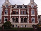
- No. 20: Two-storey house from around 1900 ( D ) with a distinctive gable and side turrets
- No. 22: Single-storey gabled house with ornamental framework with restaurant Döser Börse
- No. 23: Kindergarten
- No. 36: Restaurant
- No. 39: Two-story house with music bar
- No. 40a: Two-storey house with the parish office of St. Petri Church
- Arno-Pötzsch-Platz No. 2: Single-aisle, neo-Gothic Protestant St. Petri Church ( D ), built in 1911 as a naval garrison church according to plans by the naval garrison building inspector Stock and has been a parish church since 1948
- No. 49: Three-story historicizing house from around 1900 as a hotel
- No. 76 / 76A: Two-storey, historicizing, clinker-built double dwelling from around 1900 ( D ) with two distinctive gables and loggias on the sides
- No. 85: House of the Guttempler Sozialwerk Cuxhaven
- No. 98: Two-storey Baroque style house from around 1900 ( D ) with a three-storey side risalit
- No. 108: Art Nouveau house from around 1905 with a pastry shop
- No. 145: newer flat roof house with restaurant and the Cuxhaven bowling association
- No. 171: Two- and three-story historicizing Villa Ebel from 1904 ( D ) with a central projectile, mansard roof and high basement in a park
- No. 193: One-storey house with half hip and speech therapy kindergarten
- No. 199: Branch of the Stadtsparkasse Cuxhaven
For information
- Predöhlstrasse No. 1: Villa Deichvoigt ( D )
literature
- Peter Bussler: Historical city lexicon for Cuxhaven . Ed .: Heimatbund der Männer vom Morgenstern, 2002.
Web links
Individual evidence
- ↑ Peter Bussler: 200 years ago Cuxhaven became a seaside resort. The Göttingen philosopher Georg Christoph Lichtenberg gave the suggestion . In: Men from Morgenstern (ed.): Low German Homeland Gazette. No. 798.
- ↑ Cuxpedia: roads .
- ^ List of architectural monuments in Cuxhaven
- ^ List of architectural monuments in the outskirts of the city of Cuxhaven
- ^ List of sculptures in Cuxhaven
Coordinates: 53 ° 52 ′ 40.7 " N , 8 ° 41 ′ 5.9" E


