Sulzberg (Osterhorn Group)
| Sulzberg | ||
|---|---|---|
|
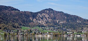
The Sulzberg over St.Gilgen; on the left in the saddle the Kühleiten |
||
| height | 1017 m above sea level A. | |
| location | near Sankt Gilgen , Land Salzburg , Austria | |
| Mountains | Osterhorn Group , Salzkammergut Mountains | |
| Coordinates | 47 ° 46 '7 " N , 13 ° 20' 30" E | |
|
|
||
| rock | Dolomite ( main dolomite ) | |
| Age of the rock | approx. 220 million years (? Carnium - Norium ) | |
| Development | Trail below | |
| particularities | Ager - Ischl - Salzach watershed | |
The Sulzberg is a 1017 m above sea level. A. high wooded hill in the Austrian state of Salzburg .
Location and landscape
The Sulzberg is located in the northwest ridge of the Zwölferhorn directly above St. Gilgen on Wolfgangsee , northeast of the Sausteigalm above Irlreit . Here the ridge divides into the Sonnberg ( 1034 m above sea level ) to the Filbling westwards and the Ellmaustein ( 1047 m above sea level ) northwest. The second accompanies the road ( B158 ) from St. Gilgen to Fuschl am Fuschlsee, between the two lies the Fuschler Ellmau , the first delimits the Faistenauer Tiefbrunnau on the north side.
Directly southeast of the summit lies the small hamlet of Faistenau, Kühleiten, at 914 m above sea level. A. From this pass, the ridge falls in a steep wall 300 meters - from the Sulzberg summit 400 meters - into the St. Gilgen valley basin. Oberellmau at 710 m above sea level A. and Hochlackenhof north at 774 m above sea level. A. are also comparatively steeply below. To the south, however, the road runs steadily from the Tiefbrunnau to the Sausteigalm; from the Perfalleckstrasse there is less than 100 meters of ascent to the junction to Kühleiten. From St. Gilgen the Sulzberg stands out as a clear summit, from the other sides it is only the end of the Sonnberggrat.
Geology and hydrography
The rock face to St. Gilgen and the Sonnberg – Filblingzug are a plaice main dolomite (uncertain Carnian - Norium of the Triassic, approx. 220 million years old), while the Oberalm formation lies on the Zwölferhorn . The hard dolomite forms the crags, while the clayey, marly limestone of the Zwölferhorn forms the gentler ridges. Directly down from the summit there is a series of Werfen formation (older: Lower Triassic ) - Losenstein formation - Gaultflysch (both younger: chalk ) that are in the context of the Wolfgangsee disturbance.
The St. Gilgen page dehydrated in a mostly dry channel becomes Mühlbach (Oppen Auerbach) in the Lake Wolfgang , in Fuschler Ellmau is Ellmau Bach to Fuschl , and in the Faistenauer Tiefbrunnau flowing Brunnbach (sometimes also called Weissbach) of the Hintersee in the Almbach (Oberalm) flows. The latter goes southwest to the Salzach, so the summit forms the watershed between the catchment areas of the Inn and the Traun , whereby the Fuschlsee belongs to the area of the Ager (with Attersee and Mondsee) in the north, but the Wolfgangsee to that of the Ischl , which is to the east Bad Ischl flows into the Traun.
ways
Past the summit, the Gratzug passes Sausteig - Kühleiten and down to Oberellmau the Arnoweg (stage 56 Genneralm - Fuschl ) On the other side, the Mozartsteig runs far below in the flank from St. Gilgen- Laim via Hochlacken into the Ellmau and on to Fuschl ( Section of long-distance hiking trails 04 and 06 ).
The summit itself can only be reached by climbing.
Individual evidence
- ↑ Pre-Alps: 56 Genneralm - Fuschl am See , arnoweg.com (direct link)
- ↑ Hikes> Via the Mozartsteig , mozartblick.at

