
Sulzfluh
| Sulzfluh | ||
|---|---|---|
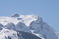
 Sulzfluh from the northwest, with throat (cirque northwest of the Sulzfluh) |
||
| height |
2818 m above sea level A. 2817.2 m above sea level M. |
|
| location | Vorarlberg , Austria and Graubünden , Switzerland | |
| Mountains | Rätikon | |
| Dominance | 2.6 km → Three towers | |
| Notch height | 475 m ↓ Drusentor | |
| Coordinates , ( CH ) | 47 ° 0 '45 " N , 9 ° 50' 23" O ( 782 548 / 209621 ) | |
|
||
| First ascent | 1782 | |


The Sulzfluh belongs with the main summit at 2818 m above sea level. A. Höhe and the 2812 m high west summit to the ten highest alpine peaks in the Rätikon between Graubünden and Vorarlberg . The Carschinahütte of the SAC is located directly below the south face of the Sulzfluh .
Its first certified ascent took place in 1782. The border summit separates the Gauertal in the Montafon from St. Antönien in Graubünden .
geology
A geological peculiarity can be observed on the ascent: You change with one step from the mica slate in the north over to the snow-white limestone.
caves
In addition to the well-known Sulzfluhhöhlen Kirchhöhle (800 m length), Seehöhle (1,500 m length), Abyssal Cave and Herrenhöhle (Herrenbalme), there are the large cave systems of Oberer Seehöhle and Apollohöhle (3,080 m length) on the eastern flank of the mountain, above the deep karst hollow the pits between Sulzfluh and Weißplatte.
Ascent
The mighty and relatively holey Kalkberg, with its cliffs sloping steeply on all sides, is one of the most beautiful mountains of the Rätikon. In the south face between Sulzfluh main summit and west summit there are several climbing routes with a high degree of difficulty. Likewise in the west face and north-west face of the neighboring Kleine Sulzfluh (2,708 m).
Tilisuna Hut
A hiking trail leads from the Tilisunahütte over the Sulzfluh plateau to the summit cross of the main summit. The ascent from the hut takes about two hours. Another moderate ascent leads from Partnun through the Gemstobel (here a short rocky step) to the eastern ridge, where it meets the path from the Tilisunahütte.
Lindauer Hut
The ascent from the Lindauer Hütte in the Gauertal takes place over the Porzalengawald, west past the bank heads and through the throat onto the bare karst plateau of the Sulzfluh plateau.
Since 2006, it has also been possible to climb the via ferrata. The entrance is above the Lindauer Hütte at 2,150 m and at 2,260 m the 350-meter-long Gauablick cave is crossed.
Partnun in St. Antöniental
In 2005 a via ferrata to the summit was opened from Partnun ( St. Antönien ) . The challenging entry into the almost vertically rising karsts is partially secured with chains. The level of difficulty for this variant is T3.
The via ferrata is 750 m long with an altitude difference of around 450 m. The climbing time for the via ferrata is approx. 2 ½ hours. It takes around 1½ hours to get started from Partnun, around 1 hour from Carschinahütte and around 2 hours from Tilisunahütte .
Of course, it is not absolutely necessary to climb the mountain vertically, if you prefer it to be challenging but more leisurely, you can hike along the entire Rätikon chain on the "Prättigauer Höhenweg" long-distance hiking trail.
Impressions

View from Bartholomäberg (winter)
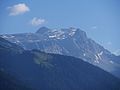
View from Bartholomäberg (summer)

Sulzfluh with Carschinahütte
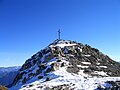
Summit of the Sulzfluh

Sulzfluh summit from the path from the Tilisuna hut

Sulzfluh (left) and Weissplatte (Switzerland: Wissplatte) from Scheienfluh (Switzerland: Schijenflue), below the Partnunsee


literature
- Manfred Hunziker: Ringelspitz / Arosa / Rätikon , Alpine Tours / Bündner Alpen , Verlag des SAC 2010, ISBN 978-3-85902-313-0 , p. 588
- Johann Catani: Comments on a trip through the Montafunerberge to the Fermunt mountains in the company of Pastor Pol, in Julius 1780. In: Bernhard Otto (ed.): The collector, a non-profit weekly publication for alliances. 5/3/1781. Chur, p. 33ff
- Luzius Pol: Description of the Sulzfluhhöhlen. In: Bernhard Otto (ed.): The collector, a non-profit weekly publication for alliances. 6/1784, Chur, pp. 209-242
- Andreas Wildberger: On the geology and hydrogeology of the karst of the Sulzfluhhöhlen (St. Antönien, Graubünden). In: Stalactite. 2/46/1996, Swiss Society for Speleology (SSS / SGH), La Chaux-de-Fonds.
Web links
- Homepage Sulzfluh via ferrata
- Via ferrata Sulzfluh Route description with topography, overview photo, directions, etc.
- Landscape and caves in the Sulzfluh, CH / A
- Via ferrata BLODIGRINNE
Individual evidence
- ↑ Hiking Switzerland along the Rätikon, Graubünden ( Memento of the original from September 13, 2010 in the Internet Archive ) Info: The archive link has been inserted automatically and has not yet been checked. Please check the original and archive link according to the instructions and then remove this notice.