
Tilisuna Hut
| Tilisunahütte ÖAV hut category I |
||
|---|---|---|
 |
||
| location | north of the Sulzfluh ; Montafon , Austria ; Valley location: Tschagguns | |
| Mountain range | Rätikon | |
| Geographical location: | 47 ° 1 '28 " N , 9 ° 52' 21" E | |
| Altitude | 2211 m above sea level A. | |
|
||
| owner | Alpine Association Vorarlberg of the PES | |
| Built | 1879 | |
| Construction type | hut | |
| Development | Material ropeway | |
| Usual opening times | Mid June to mid October | |
| accommodation | 35 beds, 105 camps | |
| Winter room | 15 bearings | |
| Web link | Tilisuna Hut | |
| Hut directory | ÖAV DAV | |

The Tilisunahütte is a mountain hut of the Alpenverein Vorarlberg des ÖAV , in the Montafon region, in the state of Vorarlberg ( Austria ). It is located south of Tschagguns at an altitude of 2211 m north of the Sulzfluh , in a panoramic position with a view of the Montafon.
It offers 35 beds and 105 mattresses and is open in the summer season from mid-June to mid-October.
Approaches
- from Grabs, 1,365 m, walking time: 3 hours
- from Tschagguns center, 697 m, walking time: 4½ hours
- from Partnun 1801 m, (Switzerland) walking time 1½-2 hours
- from Gargellen, walking time: 4–5 hours
- from St. Gallenkirch via Gweiltal – Gweiljoch 5½ hours
Transitions to neighboring huts
- Lindauer Hütte (1,744 m) over the Steinerne Meer and Rachen, walking time: 3 hours, distance: 3 km.
-
Carschinahütte (2,236 m)
- Via Tilisunafürggele ( 2236 m ), walking time: 2 hours, distance: 4 km.
- via Gru (o) benpass
- about drusator
- House Matschwitz (1,500 m), distance: 5.2 km
- Madrisahütte (1,660 m), walking time: 3¾ hours, distance: 8.7 km.
- Wormser Hut (2,305 m), distance: 8.9 km
Tours
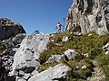
The hut is suitable as a starting point for multi-day tours from hut to hut around the Rätikon. The parallel wall paths on the north and south sides of the mountain range are connected by easily accessible crossings.
There are numerous climbing tours on the Drusen , Sulz and Scheienfluh with climbing routes from the 5th degree. There are also places for bouldering.
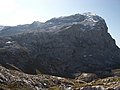
- Sulzfluh ( 2818 m ), walking time 2 hours
- Weißplatte ( 2630 m ), walking time 1½ hours
- Schwarzhorn ( 2460 m ), walking time 3½ hours
- Scheienfluh ( 2627 m ), walking time 2½ hours
On the Sulzfluh, across the Swiss border, the first via ferrata in Eastern Switzerland was opened in July 2005.
hazards
Paths with white-blue-white (alpine hiking, difficulty level T4-T6) or without markings should only be used by experienced mountaineers.
literature
- Manfred Hunziker: Ringelspitz / Arosa / Rätikon , Alpineouren / Bündner Alpen , Verlag des SAC 2010, ISBN 978-3-85902-313-0 , p. 536
- Rudolf Mayerhofer: Rätikon Alpine Club Guide for hikers and mountaineers. Written according to the guidelines of the UIAA. Bergverlag Rother, Munich (10th completely revised edition 2014), ISBN 978-3-7633-1098-2 ( Alpine Club Guide ) page 73.
photos

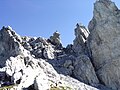
Crossing Drusator ( 2342 m above sea level ) between Drusenfluh (left) and Sulzfluh

Dilapidated guard hut just below the Drusator on the Austrian side
Drusator shortly before crossing to Switzerland
Tilisunafürggli ( 2249 m above sea level ), transition east of the Sulzfluh
Gruobenpass ( 2232 m above sea level ), transition east of the Sulzfluh

Plasseggenpass, transition east of the Scheienfluh


