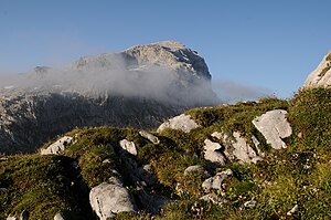
White plate
| White plate | ||
|---|---|---|
|
seen from the Tilisunafürkele |
||
| height |
2630 m above sea level A. 2628 m above sea level M. |
|
| location | Vorarlberg , Austria and Graubünden , Switzerland | |
| Mountains | Rätikon | |
| Dominance | 2.3 km → Sulzfluh | |
| Notch height | 276 m ↓ Plasseggen Pass | |
| Coordinates , ( CH ) | 47 ° 0 '35 " N , 9 ° 52' 16" O ( 784 943 / 209386 ) | |
|
|
||
| rock | Sulzfluh lime | |
| Age of the rock | Tithonium | |
| Normal way | from the northeast or east from the Tilisunahütte | |
The white plate , also called Wiss Platte , is a mountain in the Rätikon , a mountain group of the western central Alps , according to Austrian data 2630 m, according to Swiss 2628 m . The summit is exactly on the border between Austria and Switzerland ( Vorarlberg / Graubünden ). The white plate belongs to the Sulzfluh group . In the north and east it has flat, plate-like walls with carts , in the west, on the other hand, it has steep walls furrowed by deep ravines, which can only be conquered by climbing. In contrast to the neighboring Scheienfluh , the Weißplatte is rarely used. Nothing is known about a first ascent in the 19th century, but it can be assumed that hunters from the northeast reached the summit very early.
Surroundings
The Weißplatte is just under eight kilometers as the crow flies south of the Vorarlberg municipality Tschagguns in the Montafon Valley and about six kilometers northeast of St. Antönien in Graubünden . To the east the mountain falls down to the Tilisunaalpe , to the west to the uppermost Partnuntal . To the north, towards the Grubenpass crossing at an altitude of 2232 meters, the white plate emits a ridge, in the course of which the insignificant elevations Fluechopf (2438 m) and Mittelflue (2325 m) lie. A neighboring mountain along the southeast ridge , separated by a deep notch, is the Scheienfluh (also called Schijenflue ) , which is often climbed and is 2625 meters high. Further away to the west, beyond the Partnuntal, is the Sulzfluh , to the east, beyond the Tilisunaalpe, are the Sarotlaspitzen .
Bases and paths
The Weißplatte is usually only climbed when crossing it from the Tilisunahütte (2208 m) to the north via the Scheienfluh down to Gargellen . The normal route to the slab leads from the Tilisunahütte over steep crags in, according to literature, easy climbing of difficulty UIAA I from the northeast or east to the summit without a path. According to the literature, the walking time is about 1½ hours. Pure climbing tours up to UIAA grade VI lead through the west and south walls , the transition from the Scheienfluh can be mastered in moderately difficult climbing in UIAA grade II.
Web links
Literature and map
- Manfred Hunziker: Ringelspitz / Arosa / Rätikon , Alpine Touren / Bündner Alpen , Verlag des SAC 2010, ISBN 978-3-85902-313-0 , p. 652
- Günther Flaig: Alpine Club Guide Rätikon , Bergverlag Rudolf Rother Munich, 1989, ISBN 3-7633-1098-3
- Eduard Richter (editor): The development of the Eastern Alps, Volume I , publishing house of the German and Austrian Alpine Association, Berlin 1893
- National map of Switzerland 1: 25,000, sheet 1157, Sulzfluh
- Rudolf Mayerhofer: Rätikon Alpine Club Guide for hikers and mountaineers. Written according to the guidelines of the UIAA. Bergverlag Rother, Munich (10th completely revised edition 2014), ISBN 978-3-7633-1098-2 ( Alpine Club Guide ), page 260.

