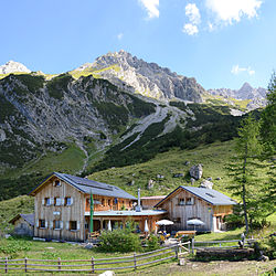
Sarotla Hut
| Sarotlahütte ÖAV hut category I |
||
|---|---|---|
| location | in the Sarotlatal; Vorarlberg ; Valley location: fire | |
| Mountain range | Rätikon | |
| Geographical location: | 47 ° 6 '14.3 " N , 9 ° 47' 11.4" E | |
| Altitude | 1611 m above sea level A. | |
|
|
||
| owner | Alpine Association Vorarlberg | |
| Built | 1902; New building in 2000 | |
| Construction type | hut | |
| Usual opening times | Mid June to early October | |
| accommodation | 4 beds, 40 camps | |
| Winter room | 2 (only emergency accommodation, emergency call device available, but no electricity, no heating option) | |
| Hut directory | ÖAV DAV | |
The Sarotlahütte is an alpine refuge of the PES in the Rätikon in Vorarlberg (Austria). It is located at 1611 m above sea level. A. on a ledge of the Sarotlatals , an orographically right side valley of the Brandner Tal , north of the Zimba .
history
The Sarotlahütte was built in 1902 by the German and Austrian Alpine Association by converting and overbuilding an alpine hut and initially offered 14 beds. In the winter of 1929/30 she suffered great damage. The repair was combined with a considerable increase in size. After the road from Bürs to Brand was expanded by 1930, which allowed the establishment of a bus route there, the number of visitors to the hut increased. After the war ended in 1945, the property of the Austrian Alpine Club was also confiscated and the Vorarlberg section dissolved. Among other things, thanks to the negotiating skills of the legendary "Z imbapfarrer " Gebhard Wendelin Gunz , it was possible to get an operating license for the house again before the end of 1945, before the newly founded Vorarlberg section then got all of its huts back from the French occupying forces. In the snowy winter of 1998/99, it was so badly damaged by avalanches that it had to be rebuilt in 2000. Part of the old hut (behind the sunshades in the picture) has been preserved and is used as an alpine hut. The emergency shelter, which is open outside of business hours, is also located here. The new hut has a power supply by means of its own small hydroelectric power station and a photovoltaic system and has been awarded the environmental seal of approval by the German and Austrian Alpine Association. The Sarotlahütte is supplied on foot and with the help of a helicopter, with which a basic covering is delivered at the beginning of the season.
Approaches and crossings
From Brand -Galaverda or from Bürserberg -Tschapina the hut can be reached in about 2½ hours via the Sarotlatal, the way from Bürs takes 3½ hours.
The Heinrich-Hueter-Hütte in the south can be reached in about three hours, the way to the Douglasshütte via Brand -Schattenlagant takes about six hours ( a good hour less when using the Lünerseebahn ). In the Brandner Tal there are regular buses, in the summer season to the valley station of the train. You can also reach the Lünersee with the Douglasshütte via the Heinrich-Hueter-Hütte and then via the Saulajochsteig or the Lünerkrinne. According to Lorüns , 6¼ hours are given.
The rugged terrain in the Sarotlatal is considered to be at risk of avalanches. The large, steep, grassy areas on the slopes that are partially invisible from the valley floor create considerable potential for avalanches.
Tour possibilities
The simplest peak in the area of the Sarotlahütte is the Great Valkastiel ( 2449 m above sea level ). Other summit destinations are:
- Zimba , 2643 m above sea level A. , walking time: 02:45
- Gottvaterspitze, 2,438 m above sea level A. , walking time: 02:00
- Zwölfer, 2297 m, Zwölferkopf, 2271 m above sea level A. , walking time: 02:30
Web links
literature
- Manfred Hunziker: Ringelspitz / Arosa / Rätikon , Alpine Touren / Bündner Alpen , Verlag des SAC 2010, ISBN 978-3-85902-313-0 , p. 605
Individual evidence
- ^ History of the Sarotla Hut
- ↑ Notice in the entrance area of the Sarotlahütte
- ↑ Description of the hut by the PES


