
Carschinahütte
| Carschinahütte SAC hut |
||
|---|---|---|
 Carschinahütte (2008) |
||
| location | southwest below the Sulzfluh ; Graubünden , Switzerland ; Valley location: St. Antönien | |
| Mountain range | Rätikon | |
| Geographical location: | 781 625 / 208980 | |
| Altitude | 2236 m above sea level M. | |
|
||
| owner | SAC Rätia | |
| Built | 1968, expanded 1993 | |
| Construction type | hut | |
| Usual opening times | Mid June to mid October | |
| accommodation | 0 beds, 85 camps | |
| Web link | carschinahuette.ch | |
| Hut directory | SAC | |

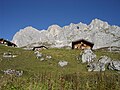
The Carschinahütte is a refuge of the Rätia section of the Swiss Alpine Club , in the Rätikon mountain group , in the Swiss canton of Graubünden . It is located north of St. Antönien at an altitude of 2236 m above sea level. M. , below the Sulzfluh , in a panoramic position with a view of the St. Antöniertal. It offers 85 beds and is open in the summer season from mid-June to mid-October. In winter it offers a shelter for ten people.
history
Jakob Eschenmoser , the most important architect of SAC-Hütten in the 20th century, was responsible for the conception and design of the new Carschinahütte building from 1968 . The first renovation followed in 1985 and an extension in 1993.
Approaches and tours
- From the post bus -Haltestelle St.Antönien Place a hiking trail in the difficulty of T1 up to the Alp Bärgli under the Chüenihorn . On its east side, you traverse high above the valley, past the Carschina lake , and in 2 ¾ hours you reach Carschinafurgga .
- In winter (T1), the hut can be reached from St. Antönien via Partnun and Brunnenegg in 2½ hours, from Partnun in 1½ hours.
The hut is located on the Prättigauer Höhenweg (marked with no. 72) from Klosters to Seewis in the Prättigau and on the cross-border hiking trail Via Alpina .
It is suitable as a starting point for multi-day tours from hut to hut around the Rätikon. The parallel wall paths on the north and south sides of the mountain range are connected by easily accessible crossings. There are numerous climbing tours at the Drusen- , Sulz- and Schijenflue with climbing routes in the UIAA level V . There are also opportunities for bouldering . Since July 2005 there has been the first "official" via ferrata in eastern Switzerland on the south face of the Sulzfluh with difficulty level D.
Transitions
- Drusa - Grüscher Älpli - Schuders
- Tilisunafürggli - Tilisunahütte
- Gruoben Pass - Tilisuna Hut
- Drusator - Lindauer Hut
- Schweizertor or Cavelljoch - Lünersee - Douglasshütte
- Golrosa - Schesaplana Hut
- Madrisahütte
- Totalphütte
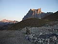
Drusenfluh, view from the Carschinahütte

Crossing Drusator ( 2342 m above sea level ) between Drusenfluh (left) and Sulzfluh

Dilapidated guard hut just below the Drusator on the Austrian side
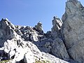
Drusator shortly before crossing to Switzerland

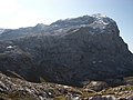
Sulzfluh with Carschinahütte
Tilisunafürggli ( 2249 m above sea level ), transition east of the Sulzfluh

Tilisunahütte ( 2208 m above sea level )
Gruobenpass ( 2232 m above sea level ), transition east of the Sulzfluh

Plasseggenpass, transition east of the Scheienfluh
Partnun with Scheienfluh west face and upstream Schijenzahn (above the middle hut)


literature
- Manfred Hunziker: Ringelspitz / Arosa / Rätikon , Alpine Tours / Bündner Alps. Verlag des SAC 2010, ISBN 978-3-85902-313-0 , p. 526.
- Jakob Eschenmoser: About mountaineering and building huts. Orell Füssli publishing house, Zurich 1973, ISBN 3-280-00648-1 .
- National map 1157 Sulzfluh (1: 25,000), ISBN 978-3-302-01157-8
- National map 238 Montafon (1: 50,000), ISBN 978-3-302-00238-5
Web links
Individual evidence
- ↑ Galli-Rudolf.ch: Eschenmoser and new experiments. In: 150 years of hut construction in the Alps, part 2. The Alps 8/2009 (PDF file)
- ↑ Sulzfluh via ferrata. Retrieved June 18, 2019 .