Drusenfluh
| Drusenfluh | ||
|---|---|---|
|
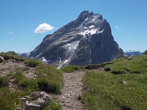
Drusenfluh from the Verajoch to the northwest |
||
| height |
2827 m above sea level A. 2827.4 m above sea level M. |
|
| location | Vorarlberg , Austria and Graubünden , Switzerland | |
| Mountains | Rätikon | |
| Dominance | 0.8 km → Three Towers | |
| Notch height | 189 m ↓ Eisjöchle | |
| Coordinates , ( CH ) | 47 ° 1 '44 " N , 9 ° 48' 6" O ( 779.6 thousand / 211 354 ) | |
|
|
||
| First ascent | August 14, 1870 by the mountain guide Christian Zudrell | |
The Drusenfluh is a mountain range between the Austrian Montafon and the Prättigau in Switzerland . At 2,827 meters, the Drusenfluh is one of the ten highest peaks in the Rätikon . The Austrian-Swiss border runs over its summit ridge running in a north-west-south-east direction .
Surname
As druse or drusen are popularly referred to in the region as Alpine alder (also: thrush , Laublatsche , Bergerle or birch alder ) from the alder genus . At this altitude, it is often a plant that creeps on the slope due to the pressure of snow. After ennoblement , Druze is said to have descended from fallen .
history
The rugged Drusenfluh was considered to be impassable until the mountain guide Christian Zudrell from Schruns, the first to climb, chiseled his "calling card" into the summit rock. His route took him on August 14, 1870 through the Öfa valley and the Imhof trough to the west ridge and over the exposed Zudrellband leading to the edge of the several hundred meter high south wall to the summit.
Karl Blodig and Eugen Sohm managed the second ascent in 1888. They climbed through the Colouir, later called “Blodigrinne”, from the northeast to the summit. On the summit they found the stone with Christian Zudrell's initials, CZ 70. Before that, this first ascent was heavily questioned in mountaineering circles. On the day he returned to Bregenz, Blodig sent a card to Zudrell with only the inscription "CZ 70". The Montafon mountain guide replied just as succinctly with "Congratulations on Drusenfluh". The two later met.
This summit stone was then brought into the valley by a mountain guide in 1995, as the weather and lightning had already hit it badly. Today this stone can be seen at the Lindauer Hütte .
Ascent
The normal ascent today leads over the Schweizermulde and the Imhofsattel, behind which you meet the Zudrells route, and the Zudrellband to the summit (walking time from the Lindauer Hütte approx. 5 hours, from the entry west of the Öfa pass 3.5 hours)
The long-distance hiking trail "Prättigauer Höhenweg", on the south side of the whole Rätikon chain, is a challenging to leisurely hike.
The Blodigrinne is now partially equipped with via ferrata. With very favorable conditions, the channel, which is extremely steep in places, can also be climbed with skis.
photos
seen from the north the pyramid of the Geißspitze ( 2334 m ) directly in front of the Drusenfluh
View from the summit to the west ridge. The arrow points the way to the descent on the Zudrellband. In the background the south walls of the Kirchlispitzen .
Distant view from the Drusenfluh to the Valais
literature
- Manfred Hunziker: Ringelspitz / Arosa / Rätikon , Alpine Touren / Bündner Alpen , Verlag des SAC 2010, ISBN 978-3-85902-313-0 , p. 572.
Web links
Individual evidence
- ↑ Brockhaus' Kleines Konversations-Lexikon, fifth edition, volume 2. Leipzig 1911., p. 24.
- ↑ Meyers Großes Konversations-Lexikon, Volume 6. Leipzig 1906, pp. 52–53.
- ↑ Adelung, Grammatical-Critical Dictionary of High German Dialect, Volume 1. Leipzig 1793, pp. 1563–1564.
- ^ Rudolf Mayerhofer: Alpine Club Guide Rätikon, Bergverlag Rother , ISBN 978-3-7633-1098-2 , p. 78
- ↑ Hiking in Switzerland along the Rätikon, Graubünden ( Memento from September 13, 2010 in the Internet Archive )


