
Three towers
| Three towers | ||
|---|---|---|
 Left the small , the middle and right the big tower . |
||
| height | 2830 m above sea level A. | |
| location | Vorarlberg , Austria and Graubünden , Switzerland | |
| Mountains | Rätikon | |
| Dominance | 8 km → Felsenkopf | |
| Notch height | 627 m ↓ Schlappiner Joch | |
| Coordinates , ( CH ) | 47 ° 1 '29 " N , 9 ° 48' 36" O ( 780 248 / 210910 ) | |
|
||
| rock | Sulzfluh lime | |
| Age of the rock | Tithonium | |
| Normal way | for the main summit from the south-east from the Lindauer Hütte over the Sporertobel | |


The Three Towers , also called "Dri Türm" and Three Drusentürme , are three peaks in the Drusenfluh group. They are located in the Rätikon , a mountain range in the western central Alps, and form a mountain range that runs from northwest to southeast.
The main summit of the towers is the fifth highest point in the Rätikon. The survey point on the summit of the Small Tower is on the border between the Austrian state of Vorarlberg and the Swiss canton of Graubünden . The middle and large towers, on the other hand, belong to the Vorarlberg area. They reach their highest point with the 2830 meter high Great Tower. Towards the south, the three towers form vertical walls up to 600 meters high. Some of these southern climbs are among the most important alpine climbing routes of the Rätikon. There is no reliable information in the literature about a first ascent in the 19th century.
The seemingly milled sporer plate on the north side of the large and middle tower is the result of a huge landslide, the traces of which are still visible today. In the Gauen parcel, several kilometers away from the Sporerplatte, there are boulders up to the size of a house that come from the Three Towers.
Under the ridge that descends from the small tower to the northeast is the Spora Cave, which can be reached with a little climbing. This consists of a high corridor extending horizontally into the mountain, which at its end merges into a shaft, the opening of which leads into the Sporatobel. The opening, which is several meters in size, can be covered with snow in winter, which is why you should pass this area with appropriate caution when entering the ravine. The conspicuous Sporaturm ( 2489 m ) stands on the aforementioned ridge. The normal ascent leads over the Sporersattel at its southwestern foot.
Surroundings
The three peaks belong to the Drusenfluh group, which forms a roughly four kilometers long, sharply cut, mighty ridge from northwest to southeast. The main summit of the Three Towers lies to the northwest, 200 meters to the southeast is the Middle Tower and another 300 meters away, separated by a narrow field of firn , the Small Tower. In the northwest, the Eistobel extends with a small glacier up to a height of 2638 meters, just below the main ridge of the Drusenfluh group. In the southeast, the Sporer or Sporatobel is often snow-free in summer. The neighboring mountain is in the northwest, in the course of the main ridge, separated by the Eisjöchle at an altitude of 2638 meters, the 2827 meter high Drusenfluh .
In the southwest, along the ridge, separated by the Drusentor path crossing ( 2341 m ), the Sulzfluh group begins with the 2817 meter high Sulzfluh . There are no peaks worth mentioning in the northeast and southwest.
The Great Tower has a strong geographic dominance . As a result, it offers an excellent view that, when the air is clear, extends to the Weisshorn in the Valais Alps, 190 km away . The closest permanently inhabited settlements are Schiers in Graubünden, a good six kilometers as the crow flies, in the south-west, and Vorarlberger Latschau, 8 km north-west, a plot of Tschagguns in the Montafon .
Heights of the Three Towers
(according to the information on the national map of Switzerland 1: 25,000)
- Big tower: 2830 m
- Middle tower: 2782 m
- Small tower: 2754 m
Base and ascent
As a base for an ascent of the towers from the northeast which serves Lindauerhütte to 1,744 meters in the upper Gauertal, in the lower Gauertal is the Gauertalhaus available. For the climbing tours through the south faces of Drusenfluh and Sulzfluh, the Carschinahütte located at 2236 meters above sea level below the southwest face of the Sulzfluh, north above St. Antönien in Graubünden, is the ideal base.
The normal route to the Great Tower leads over the Drusentorweg from a north-easterly and then south-easterly direction, coming over the Sporersattel and -tobel to the summit. According to literature, the walking time from the Lindauer Hütte is up to 3½ hours. In late winter, this route is a demanding tour for ski mountaineers . An alternative, with which the key point of the normal ascent on the Sporasattel can be avoided, allows a round tour and leads through the Öfa valley and the «zoo» located below the Sporerplatte to the Sporatobel. The climbing routes through the south walls of the Three Towers have been opened since the 1950s. The key points of the journeys described in the literature as "pleasure climbing" are in the difficulty levels UIAA V to VII + . The climbing garden of the Lindauer Hütte is located on the northeastern slopes of the zoo, at the eastern foot of the three-tower massif.
Literature and map
- Manfred Hunziker: Ringelspitz / Arosa / Rätikon , Alpineouren / Bündner Alpen , Verlag des SAC 2010, ISBN 978-3-85902-313-0 , p. 576.
- Günther Flaig: Alpine Club Guide Rätikon. Bergverlag Rother , Munich 1989, ISBN 3-7633-1098-3 .
- Eduard Richter (editor): The development of the Eastern Alps. Volume I, publishing house of the German and Austrian Alpine Club, Berlin 1893.
- National map of Switzerland 1: 25,000, sheet 1157, Sulzfluh
photos
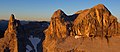
the three towers at sunrise

The spora saddle and the pointed spora tower in the middle of the lower half of the picture. Well visible on the right: the Eisjöchle with the "pig tooth"

middle Drusenturm, on the right the Sulzfluh, in front of it the small tower

in the Sporatobel, the rock needle on the left is the small tower

three towers (left) and Drusenfluh (right) seen from Bartholomaeberg
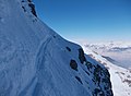
The exposed key point on the normal ascent on the Spora saddle in winter


Web links
- Tour description on the Three Towers on www.jump2nature.de ( Memento from February 11, 2013 in the web archive archive.today )
Individual evidence
- ↑ PeakFinder Ltd [email protected]: Mountain panorama: Three towers. Retrieved March 6, 2019 .