
Tamale (Ghana)
| Tamale | |||
|---|---|---|---|
|
|||
| Coordinates | 9 ° 24 ′ N , 0 ° 51 ′ W | ||
| Basic data | |||
| Country | Ghana | ||
| Northern region | |||
| ISO 3166-2 | GH-NP | ||
| height | 180 m | ||
| surface | 750 km² | ||
| Residents | 371,351 (2010) | ||
| density | 495.1 Ew. / km² | ||
| Culture | |||
| Twin cities |
|
||

Tamale is the capital of the Northern Region in Ghana .
Tamale is located about 400 kilometers north of Kumasi in the northern Ghanaian savannah landscape at an altitude of 180 m. Millet , cassava , cotton and peanuts are grown in the area . An important traffic junction is the Yapei port , also known as Tamale Port , located about 30 kilometers southwest on Lake Volta , from where ships to Akosombo leave in the south of the lake.
80 percent of the 371,351 inhabitants (2010 census) belong to the Dagomba people , around 84 percent are Muslims .
The city is the seat of the Technical University College of Tamale (TUCT), the University for Development Studies , founded in 1992 , and the Tamale Institute of Cross Cultural Studies (TICCS). Other institutions such as the United States Agency for International Development (USAID) have opened offices in Tamale. The sports stadium has a capacity of 21,017 seats and hosted the African Cup of 2008 (African Nations Cup 2008) in Ghana.
Tamale is also the seat of the Archdiocese of Tamale . There is a partnership between the diocese of Münster and the dioceses of the ecclesiastical province of Tamale. The contact goes back to 1982, since 2006 there has been an exchange program between the Ghanaians and the Catholic Student and University Community (KSHG) and the Catholic theological faculty in Münster, alternating year after year.
Population development
The following overview shows the population by area since the 1970 census.
| year | Residents |
|---|---|
| 1970 | 83,653 |
| 1984 | 135,952 |
| 2000 | 202.317 |
| 2010 | 371.351 |
sons and daughters of the town
In Tamale were born:
- Habib Mohamed (* 1983), Ghanaian soccer player
- Ibrahim Mahama (* 1987), Ghanaian conceptual artist
- Abdul Rahman Baba (* 1994), Ghanaian soccer player
- Bawa Abudu , musician
gallery

Mosque in the city center

Bank in Tamale (November 1999)
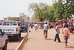
Bolga Road in Tamale (November 1999)

Tamale market

Tamale Stadium


Climate table
| Tamale | ||||||||||||||||||||||||||||||||||||||||||||||||
|---|---|---|---|---|---|---|---|---|---|---|---|---|---|---|---|---|---|---|---|---|---|---|---|---|---|---|---|---|---|---|---|---|---|---|---|---|---|---|---|---|---|---|---|---|---|---|---|---|
| Climate diagram | ||||||||||||||||||||||||||||||||||||||||||||||||
| ||||||||||||||||||||||||||||||||||||||||||||||||
|
Average monthly temperatures and rainfall for Tamale
Source: wetterkontor.de
|
|||||||||||||||||||||||||||||||||||||||||||||||||||||||||||||||||||||||||||||||||||||||||||||||||||||||||||||||||||||||||||||||||||||||||||||||||||||||||||||||||||||
Individual evidence
- ↑ ghanadistricts.com ( Memento of the original from March 4, 2016 in the Internet Archive ) Info: The archive link was inserted automatically and has not yet been checked. Please check the original and archive link according to the instructions and then remove this notice.
- ↑ 2010 Population and Housing Census (PHC). Ghana Statistical Service
- ↑ "Augustine Azupio died" , Bishopric Munster 12 December 2007
- ↑ Ghana: Regions & Cities - Population Statistics, Maps, Charts, Weather and Web Information. Retrieved January 6, 2019 .