
Tayap
| Tayap | |||
|---|---|---|---|
|
|||
| Coordinates | 3 ° 49 ′ N , 10 ° 54 ′ E | ||
| Basic data | |||
| Country | Cameroon | ||
| Center | |||
| ISO 3166-2 | CM-CE | ||
| Residents | 254 | ||
 Tayap
|
|||

Tayap is a small village in the Center region in Cameroon , between the capital Yaoundé (86 km) and Douala (164 km). The village belongs to the department of Nyong-et-Kéllé and the municipality of Ngog-Mapubi .
Located north-west of the rainforest of the Congo Basin , the second largest forest area in the world after the Amazon rainforest , the village of Tayap is also suffering from deforestation , which affects the entire country, caused, among other things, by population growth , the expansion of forestry , the collection of firewood and the slash and burn .
A pilot program to promote agroecology and ecotourism has been in use in Tayap since 2011 , which aims to support the country's biological diversity and the development of income-generating activities for its residents.
geography

Geographical location
The village of Tayap is located at the latitude and longitude 3 ° 49 ° 2.067``N and 10 ° 54'5.106''E. Tayap borders the villages of Omog and Mamb in the north, Mamb Kelle and Song Mpeck in the west, Lamal Pougue in the east and Nlep be and Ngong in the south.
Tayap is 86 km from Yaoundé (12 km from Boumnyebel on the state road N ° 3 Douala-Yaoundé) and extends along a 10-kilometer track that connects to the Douala-Yaoundé expressway. Tayap is connected to the state road N ° 3 by a rural dirt road, which is maintained irregularly and is difficult to drive during the rainy season. The entrance to the village of Tayap is at the level of the village of Omog, on the N ° 3 state road that connects Douala and Yaoundé. Tayap is 6 kilometers from Omog.
climate
Tayap has a humid equatorial climate with four seasons : two dry seasons and two rainy seasons . The main rainy season extends from August to October and a smaller rainy season from March to May. The big dry season lasts from November to February and the short dry season from June to July. The nearest weather station is in Éséka , around 20 km southwest of Tayap. The average annual temperature is 25 ° C. The annual rainfall varies between 1500 and 2500 mm.
Geology and Speleology

The village of Tayap is characterized by its altitude of 350 meters and its steep slopes. The soil is rich in pebbles ( quartzite ) and igneous rocks such as pyroxenite and mica schist .
The area around Tayap is rich in caves. On the hills at 544 meters above sea level, there are caves and rocks that have been formed into an impressive series of staggered steps by ancient speleological forces. White-necked wilted crows, an endangered species of bird, nest in one of these caves. One of these rock formations, in the shape of a triangle, forms an ideal hiding place at a height of over 100 meters and was used as a hiding place by the nationalists during the struggle for the independence of Cameroon.
environment
Tayap is located in the north-western area of the rainforest of the Congo Basin. The vegetation consists mainly of forest areas. There are two types of forest: the primary forest , on the top of the hills, and the secondary forest , a result of the clearing of primeval forests for agriculture and forestry. The damage to the rainforest in the Congo Basin affects very specific areas. The deforestation is primarily due to the ever-increasing development of forestry , Cameroon an economical alternative to the declining cocoa and coffee prices, most of the income of the country in 1990, but also due to the slash and burn , a common practice in the tropical forests. The annual amount of deforestation in Cameroon is between 0.5 and 1.2 percent. The estimated annual amount of deforestation is between 80,000 and 200,000 hectares in absolute terms. The village currently has over 1,400 hectares of forest up to 1,200 meters above sea level. M., that is about 30% of its total area. The forest consists mainly on the tops of the hills.
history
After the Second World War , Cameroon was placed under a Franco-British trustee mandate and, like Togo , was given the status of a country associated with the French Union. From 1940 and 1950, the Union des Populations du Cameroun (UPC, Union of the Peoples of Cameroon), a national liberation movement led by Ruben Um Nyobé , played a key role in Cameroon's struggle for independence. After fierce fighting in which many Cameroonians were killed, the UPC was dissolved in 1955 and its leaders formed a resistance group. The area around Tayap became one of the resistance centers in the land of the Bassa, led by Ruben Um Nyobé. According to Achille Mbembe , historian of post-colonialism , as of 1956 the village of Omog had around fifteen peasants who had joined the resistance.
Administration and politics
Tayap is a third degree executive. In Cameroon, the executive holidays form the various levels of the administrative management organization. Before colonization, the chief holidays formed micro-states; they can be first, second or third degree, depending on their territorial or historical status. The last head of the village, Yogo Germain François, died on June 17, 2008. Since then, the village has remained without a head. Free, transparent elections should be organized by the administration of Cameroon so that the village has a democratically elected head again. The operation, administration and development of the village are currently under the leadership of the Association des ressortissants des villages d'Omog et de Tayap (AROTAD), an association of the inhabitants of the villages of Omog and Tayap.
There are two parties in the village: the Union des populations du Cameroun (UPC, Union of the Peoples of Cameroon) and the Rassemblement Démocratique du Peuple Camerounais (RDPC). In the last parliamentary and local elections, which took place in Cameroon on September 30, 2013, the UPC received 32% of the vote and the RDPC 68%.
Population and society
Demographics

In the last census in 2010, Tayap had 254 inhabitants (57 households), of which 132 men (52%) and 122 women (48%). The population of Tayaps corresponds to 2.5% of the population of the municipality of Ngog Mapubi. The population is predominantly young and belongs to the Bassa tribe , with a minority (8%) belonging to other Cameroonian tribes (Bamenda, Bamileke , Hausa , Béti). It is spread over a large number of small hamlets along the roads and slopes. These are between 0.5 and 2 km apart. Tayap and Libolo are the two main villages. The entire village has about sixty houses.
Healthcare
Tayap does not have a health facility. The nearest health center is in Boumnyebel, 12 km from Tayap. The nearest hospital is in Yaoundé (86 km from Tayap).
Other basic social benefits
Three boreholes or wells that are operated with hand pumps supply the village of Tayap with drinking water. The water is then brought to the respective place of use in buckets or canisters. Although a high-voltage line runs past the village of Omog, Tayap is not supplied with electricity. The development of Tayap is significantly hampered by the lack of electricity. The very weak winds also do not allow wind turbines. In addition, there are no streams or rivers with hydropower potential in the vicinity of the village (except about 8 km away, only accessible via a bush path).
education

In 2003 the residents of Tayap built a primary school. In the first year after the school opened, 34 students from the age of 6 attended the school and, since 2010, 75 students. The school is halfway (around 1.5 km) between the villages of Libolo and Tayap. In April 2006, the Cameroon government approved two additional classrooms, giving the public primary school in Tayap four classrooms. Two levels are taught in each class, thus ensuring that the six levels of primary school are taught. After primary school, the village pupils attend secondary schools in Lamal-Pougoue or in Mamb.
religion
The majority of the population in Tayap is Christian and belongs to the Catholic or Protestant faith. There are two churches in the village: the Presbyterian Church of Cameroon and the Catholic Church.
Culture
The people of Tayap are closely related to the following four elements of their culture:
- The traditional cuisine, with the legendary fish dish bongo'o tchobi , which is eaten with tannia, plantains , manioc or manioc sticks, the local breakfast consisting of a manioc cake called mintoumba , and the traditional palm wine .

Cassava sticks

Fried fish

chocolate


- The rhythms of the country, with the Ngola chants and the hip dance Assiko
- The traditional wedding in three steps ( Li bat Ngond , which means something like " marriage proposal " in the language of the Bassa , li ti pôs or "give the bottle" stands for the engagement and bijeck bi lon , "food of the family" for the traditional marriage)
- The native plants that play an important role in the Phytotherapy play
economy
In 2013, 179 people were employed. The majority of employment opportunities are in agriculture.
Agriculture
The agriculture is the main source of income of the village Tayap. It will also work with non-wood products traded. The economic activities are mainly focused on agriculture and the commercial economy ( cocoa and oil palms ), the demand economy ( plantains , cassava , tannia , taro , peanuts , bananas), fruit growing ( safou , mango , lemons , oranges , grapefruit , papaya , Kola nut ) and growing vegetables (allspice, various vegetables). These agricultural products are sold in Boumnyebel and Yaoundé.

Kola fruit
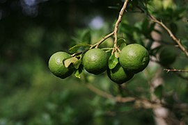
Oranges

cocoa

Tannia field


Other activities
The residents of Tayap also breed, hunt and fish for small animals . Tayap has six presses for palm oil extraction and solidarity microfinance . With the construction of two eco-lodges and the upgrading of the existing guest rooms, ecotourism offers another source of income for the village. For some of the villagers, illegal logging also contributes to their livelihood.
Local development initiatives
A pilot program to promote agroecology and ecotourism has been in place in Tayap since 2011, which aims to support the country's biodiversity and the development of income-generating activities for its residents. The program Les Vergers Écologiques de Tayap (The Organic Orchards of Tayap) received the 2011 SEED Award (Supporting Entrepreneurs for Environment and Development), a global partnership for sustainable development, which was set up in 2002 on the occasion of the World Summit on Sustainable Development in Johannesburg . was launched by UNEP, UNDP and UICN.
Between 2014 and 2015, this program reforested 110 hectares of forest, organized three themed school trips for the local children and created some “green” jobs for young people. In order to promote ecotourism as an alternative source of income for the villagers, two eco-vacation homes were built. With the support of the UNDP's SGP / GEF microcredit programs, the village community has made a circulating fund of 1 000 000 FCFA available to give women the opportunity to create new entrepreneurial activities through micro-credits. As part of this program, a series of comics was also published, which explains the history of development in Tayap and the problems caused by deforestation and slash and burn for the African villages.
In 2015 the “Vergers Écologiques de Tayap” received the “Challenge Climat Agriculture et Forêts” award from the AFD (French Development Aid) and the CIRAD (Center for International Agricultural Research and Development), measures to mitigate the effects of climate change in the countryside. and livestock farming. In 2016, the project was awarded the ISTF Innovation Prize from Yale University.
traffic
Tayap is approximately an hour from Yaoundé and two hours from Douala via the state road that connects these cities. The Douala-Yaoundé railway does not go through Tayap.
Individual evidence
- ↑ Main source: Agripo, 2014, La monographie du village de Tayap . Tayap, Editions Agripo, 36 pp.
- ^ A b c Center for International Forestry Research, Collectif, L'Impact de la Crise Économique sur les Systèmes Agricoles et le Changement du Couvert Forestier dans la Zone Forestière Humide du Cameroun , 2000 (accessed on November 21, 2014), p. 16
- ↑ a b Clément Yonta Ngoune, "Le contexte géologique the indices de talc de la région de Boumnyebel" Université Henri Poincaré (Nancy I) et université de Yaoundé I (dissertation), 2010 (accessed on 21 November 2014), p 425
- ↑ C. Olivry, MESRES ORSTOM, Monographies hydrologiques de l'OSTOM , Paris, 1986 ( ISBN 2-7099-0804-2 ), pp. 70 and 88
- ^ "Convention sur le commerce international des espèces de faune et de flore sauvages menacées d'extinction conclue à Washington" , March 3, 1973 (accessed on October 14, 2014)
- ↑ De Wasseige C., de Marcken P., Bayol N., Hiol Hiol F., Mayaux Ph., Desclée B., Nasi R., Billand A., Defourny P. et Eba'a R., Les forêts du bassin du Congo - État des Forêts 2010 , Luxembourg, Office des publications de l'Union Européenne, 2012, 276 pp. ( ISBN 978-92-79-22717-2 ), p. 17
- ^ "La guerre cachée de la France au Cameroun" , on Liberation , September 17, 2008 (accessed October 15, 2014)
- ↑ Achille Mbembe, La naissance du maquis dans le Sud-Cameroun (1920-1960). Histoire des usages de la raison en colonie , Karthala, Paris, 1996, 438 pp. ( ISBN 978-2-86537-600-1 )
- ^ Troisième Recensement Général de la Population et de l'Habitat (3e RGPH), Bureau Central des Recensements et des Études de Population du Cameroun (BUCREP), 2010
- ↑ a b “Système d'Information Géographique” , Cameroon (accessed on October 15, 2014)
- ↑ "Mamb: le CES ouvre ses portes" ( Memento of the original from March 25, 2016 in the Internet Archive ) Info: The archive link was inserted automatically and has not yet been checked. Please check the original and archive link according to the instructions and then remove this notice. (accessed on October 15, 2014)
- ↑ "Report de la brigade nationale de contrôle pour l'exercice 2013 du Ministère des eaux et de la forêt" ( page no longer available , search in web archives ) Info: The link was automatically marked as defective. Please check the link according to the instructions and then remove this notice. (accessed on October 15, 2014)
- ^ "Tayap Eco-Orchards" , sur seedinit.org (accessed on October 14, 2014)
- ↑ "AGRIPO, nos réalisations en chiffres" (accessed on February 6, 2016)
- ^ "Projet pilote de développement agro-écologique et éco-touristique pour la protection de la biodiversité et des terres dans le village de Tayap" (accessed on October 14, 2014)
literature
- Achille Mbembe , 1996, La naissance du maquis dans le Sud-Cameroun (1920–1960). Histoire des usages de la raison en colonie , Paris, Karthala, 438 p., ( ISBN 978-2-86537-600-1 )
- Clément Yonta Ngoune, 2010, Le contexte géologique des indices de talc de la région de Boumnyebel , Université Henri Poincaré (Nancy I) et université de Yaoundé I (dissertation), 425 pp.
- Agripo, 2014, La monographie du village de Tayap . Tayap, Editions Agripo, 36 pp.
- Agripo, Winnie et Stéphanie Dordain, Tayap, la forêt enchantée , CreateSpace Independent Publishing Platform, 2015, 42 p. (Comics series)
- Adeline Flore Ngo Samnick (with Mireille Esther Ngo Mbanga and Émilienne Lionelle Ngo Samnick), Aux 1 000 saveurs de Tayap , CreateSpace Independent Publishing Platform, 2016, 104 pp. ( ISBN 978-1-5192-7117-4 )
Web links
- Agripo
- Nicolas Richoffer, “Les vergers écologiques ont tout bon au Cameroun” , 20 minutes , 23 February 2015
- "Les nouveaux résilients (4/7): la militante antibrûlis" , Terra Eco , March 6, 2015
- Christophe Paget, "Le journal de la COP21 du vendredi 11 décembre" , RFI , December 11, 2015 (interview)
- Josiane Kouagheu, “Tayap, le village écologique qui crée des emplois verts au Cameroun” , Le Monde Afrique , 11 February 2016