
Tehachapi Mountains
| Tehachapi Mountains | |
|---|---|
 |
|
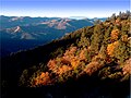
 Eastern Tehachapi Mountains as seen from the west. Tehachapi Mountain, Double Mountain, and Covington Mountain. |
|
| Highest peak | Double Mountain ( 2433 m ) |
| location | California , United States |
| part of | Transverse ranges |
| Coordinates | 35 ° 2 ′ N , 118 ° 29 ′ W |
The Tehachapi Mountains [ tɘ'hæʃəˌpi ] are part of the Transverse Ranges in the US state of California . The mountain range located in southern California runs from southwest to northeast and connects the southern California Coast Mountains in the west with the southern end of the Sierra Nevada in the east. The mountain range extends for approximately 40 miles in south Kern County , southeast of Bakersfield, and varies in elevation from approximately 1,220 m to 2,400 m . The highest mountain is Double Mountain with a height of 2433 m .
The name Tehachapi possibly comes from the language of the Kawaiisu Indians, where tihachipia means something like difficult to climb . However, it is unclear what the Kawaiisu used this term for. The botanist William Henry Brewer first used the name in its current meaning in 1863.
description

The mountains form the watershed between the San Joaquin Valley in the northwest and the Antelope Valley in the southeast, part of the Mojave Desert or the Great Basin . The mountain range is crossed at its southwestern end by Interstate 5 at Tejon Pass . The Tehachapi Pass , located at the northeastern end of the mountain range, is less steep. It is crossed by the Southern Pacific Railroad with the Tehachapi Loop , California State Route 58 and the California Aqueduct , which supplies southern California with water from the Sacramento-San Joaquin Delta . The Los Angeles Aqueduct flows south past the mountains.
Although the Tehachapi Mountains are neither long nor high, many Californians consider them to be the border between Northern and Southern California (even if some believe that Southern California extends further north into the Fresno area ). A split in California was discussed twice, in 1860 and 1965, and both drafts suggested the ridge of the Tehachapi Mountains as the new boundary. Both proposals failed. The Ridge Route was the first road built over this mountain range in the early 20th century, connecting northern and southern California. Today Interstate 5 follows the original route in many places. The construction of the Ridge Route is said to have helped prevent a split into two separate states.
The Monolith cement works , which supplied the cement for the construction of the Hoover Dam and other public works, is located in the Tehachapi Mountains east of the Tehachapi Pass. The Alta Wind Energy Center , the largest wind farm in the country (as of September 2016), is located in the area.
geology
The Tehachapi Mountains are a result of the movements of the southeast, parallel to the mountain range Garlock Fault , a major transform fault that runs from the San Andreas Fault in the west to the Sierra Nevada Fault in the east and beyond. The fault is a left-sided fault and is unusual for California, its motion contrasts with most of the faults in the state, which are right-sided faults.
Flora and fauna
The forests consist mainly of oaks and, in the mountain regions, of the characteristic conifers . Some of the rare species include incense cedar , Colorado fir, and in a few remote locations there are small populations of American aspen . Other plants found here are sacred flowers and cercocarpus .
68 species of birds have been recorded in the Tehachapi Mountains (among them the diademed jay ), many of which also feed on acorns of the California black oak. Mule deer , pumas , coyotes , foxes , black bears , bobcats and raccoons are found in mammals .
climate
The mountain range shows a cross-section through several climate zones , it forms the border between the arid climate of the Mojave Desert in the south and the Mediterranean climate in most of the mountains up to the northern San Joaquin Valley . The higher areas belong to the subalpine climatic zone .
The Great Basin to the east and southeast typically receives only a few inches of rainfall per year, usually in winter. However, summer can bring localized torrential rain. The prevailing wind direction is northeast, the wind then whistles regularly over the passes and into the east-west canyons and valleys of the Tehachapi Mountains. In the northwest is the San Joaquin Valley with its extensive slopes and their oak savannah . The Tehachapi Mountains collect the sea and valley moisture, which for many weeks a year settles in dense fog upwind on the slopes of the mountains. The higher north-facing (subalpine) slopes are covered with conifers , California black oaks and Californian bush oaks, while evergreen oaks, shrubs and gray pines occur on the southern (continental-climatic) slopes , typical for the relationship between the moisture-retaining northern slopes and the exposed southern slopes. The summit zone is semi-arid . Canyons, including those on the south side, can have flowing water year-round, especially where the slope provides additional rainfall from passing storms and during the spring thaw.

Tehachapi, Double and Covington Mountains

Sierra Crest as seen from Cummings Mountain

Alpine forest above Tehachapi
Tejon Ranch with Frazier Mountain


summit
- Double Mountain ( 2433 m )
- Tehachapi Mountain ( 2426 m )
- Cummings Mountain ( 2365 m )
- Bear Mountain ( 2109 m )
- Black Mountain ( 1733 m )
- Grapevine Peak ( 1468 m )
See also
Web links
- Tomo-Kahni State Historic Park website (located in the Tehachapi Mountains)
Individual evidence
- ^ Tehachapi Mountain. In: summitpost.org. November 22, 2007, accessed December 18, 2010 .
- ^ Up and Down California in 1860-1864. The Journal of William H. Brewer: Book 4, Chapter 2 TEJON — TEHACHAPI — WALKER'S PASS. 1863, accessed December 18, 2010 .