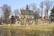
Tenczynek
| Tenczynek | ||
|---|---|---|
 Help on coat of arms |
|
|
| Basic data | ||
| State : | Poland | |
| Voivodeship : | Lesser Poland | |
| Powiat : | Krakowski | |
| Gmina : | Krzeszowice | |
| Geographic location : | 50 ° 7 ′ N , 19 ° 37 ′ E | |
| Height : | 270-330 m npm | |
| Residents : | 3436 (August 20, 2010) | |
| Postal code : | 32-067 | |
| Telephone code : | (+48) +48 (12) | |
| License plate : | KRA | |
| Economy and Transport | ||
| Next international airport : | Krakow | |
Tenczynek is a village in southern Poland that belongs to the Krzeszowice municipality . It is located on Olszówka in the Powiat Krakowski , Lesser Poland Voivodeship .
history
The place was first mentioned in 1319.
When Poland was partitioned for the third time in 1795, Tenczynek became part of the Habsburg Empire . In the years 1815-1846 the village belonged to the Republic of Krakow , in 1846 it was annexed again as part of the Grand Duchy of Krakow to the countries of the Austrian Empire. From 1855 Tenczynek belonged to the Chrzanów District .
In 1918, after the end of the First World War and the collapse of the Austro-Hungarian monarchy, Tenczynek became part of Poland. This was only interrupted by the occupation of Poland by the Wehrmacht in World War II . It then belonged to the district of Krenau in the administrative district of Katowice in the province of Silesia (since 1941 province of Upper Silesia ).
Sons and daughters of the place
- Tadeusz Arkit (* 1955), politician

