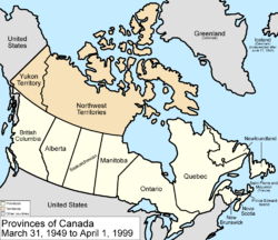
Territorial development of Canada
This article shows the territorial development of Canada with all changes of the external and internal borders.
Remarks
- The Northwest Territories consisted of different districts, but the Keewatin District had a higher status, which is why this is also noted. In 1905 it was annexed to the Northwest Territories and finally dissolved in 1999 when Nunavut was founded .
- The maps used on this page depict the current boundaries of Labrador for the sake of simplicity , as the territorial claims of Québec and Newfoundland overlap.
- The Alaska border conflict with the United States is not included on the maps , as it only affects a narrow strip of territory.
development
- July 1, 1867
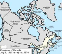
The Dominion Canada is created from three areas of British North America : the two colonies of New Brunswick and Nova Scotia and the province of Canada , which is now divided into the provinces of Ontario and Québec .
- July 15, 1870
The United Kingdom cedes most of the territory still remaining in British North America to Canada: Rupert's Land and the Northwest Territories , when they come together they become the Northwest Territories . Previously, under the Rupert's Land Act of 1868, the private Hudson's Bay Company was compensated £ 300,000.
The Manitoba Act goes into effect the same day, 1870. This expands the Dominion Canada by the huge territories and within it a square cut area around the city of Winnipeg to the province of Manitoba .
- July 20, 1871
The British United Colonies of Vancouver Island and British Columbia become the Canadian Province of British Columbia . The expansion of Canada thus reaches the east coast of the continent and now extends from sea to sea between the Pacific , the Atlantic and the Arctic Ocean .
- July 1, 1873
The British colony of Prince Edward Island becomes a province. The island off the Atlantic coast of New Brunswick and Nova Scotia will thus become one of the three maritime provinces .
- July 26, 1874
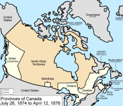
The Ontario borders are provisionally shifted north and west, expanding the province 's territory at the expense of the Northwest Territories . This measure is considered to anticipate future development and the expected population growth.
- April 12, 1876
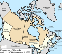
A central strip of the Northwest Territories is spun off as the Keewatin District , which borders Manitoba and Ontario to the south.
- September 1, 1880
The United Kingdom cedes the British Arctic Territories to Canada, which will join the Northwest Territories .
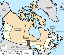
- July 1, 1881
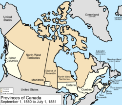
Manitoba's boundaries are being stretched, but a significant part of it is controversial as Ontario claims it.
- May 7, 1886
The Keewatin District will be reduced in size by changing its southwestern border .
- August 12, 1889
The disputed area between Manitoba and Ontario is added to Ontario, whose borders are shifted further north and west.
- October 2, 1895
The Keewatin District is expanded to the east.
- June 13, 1898
The Yukon Territory is split off from the Northwest Territories . The north-western border of Québec is shifted north to Hudson Bay.
- May 23, 1901
The eastern border of the Yukon Territory is being adjusted.
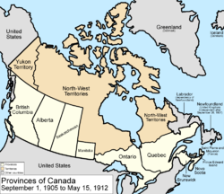
- September 1, 1905
The Keewatin District is returned to the Northwest Territories ; the provinces of Alberta and Saskatchewan are formed from their southern parts .
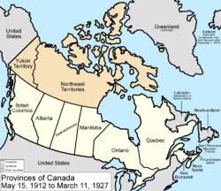
- May 15, 1912
Manitoba , Ontario , and Québec will be expanded northward to their present-day boundaries. Five years earlier, the Newfoundland colony became a Dominion in the British Empire.
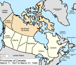
- March 11, 1927
A British court ruled in favor of Labrador in a border dispute between Labrador and Québec . Canada then has to cede a small area to the Dominion Newfoundland .
- March 31, 1949
The independent Dominion of Newfoundland and its dependent territory of Labrador join Canada and become the Province of Newfoundland .
- April 1, 1999
The Nunavut Territory is split off from the Northwest Territories and given special rights for the native Inuit . Its capital is Iqaluit on Baffin Island .
In addition, on December 6, 2001, the name of the province of Newfoundland was changed to Newfoundland and Labrador , and on April 1, 2003, the name of the Yukon Territory was changed to Yukon .
- currently
Canada now consists of ten provinces that form a belt in the south, as well as three territories in the north, which - apart from Hudson Bay and Ungava Bay - lie north of the 60th parallel (see also Provinces and Territories of Canada ).

