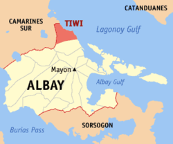
Tiwi (Albay)
| Municipality of Tiwi | ||
| Location of Tiwi in the province of Albay | ||
|---|---|---|

|
||
| Basic data | ||
| Region : | Bicol region | |
| Province : | Albay | |
| Barangays : | 25th | |
| District: | 1. District of Albay | |
| PSGC : | 050518000 | |
| Income class : | 2nd income bracket | |
| Households : | 8036 May 1, 2000 census
|
|
| Population : | 53,120 August 1, 2015 census
|
|
| Coordinates : | 13 ° 28 ' N , 123 ° 41' E | |
| Postal code : | 4513 | |
| Area code : | +63 52 | |
| Mayor : | Jaime Villanueva | |
| Website: | www.tiwi.gov.ph | |
| Geographical location in the Philippines | ||
|
|
||
Tiwi is a municipality in the Albay Province of the Philippines .
history
Before the community of Tiwi was founded by the Spaniards, the area of today's main settlement and the barangays Baybay, Libjo, Cararayan and Naga was still part of the Pacific Ocean , and the hill on which the barangays Bolo and Putsan are now located was an island. It was not until the eruption of the now dormant Malinao volcano that this area of land and the hills of Bolo and Putsan was connected to the island of Luzon . In 1658, Spanish Franciscans erected a cross near the coast north of Malinao . The friars named the place Tigbi after the name of a plant found there. Later it became Tivi and finally today's form Tiwi. The settlement was initially a district of Malinao before becoming a formally independent pueblo in 1696. As a Catholic parish, it was administered by a secular priest. The parish then belonged to the diocese of Nueva Caceres, now an archdiocese. In its prehistoric times, the settlement had 1,105 houses, a parish church, a community-financed elementary school and a cemetery outside the town limits. Originally the inhabitants were engaged in fishing and the production of rice , corn , sugar cane , indigo , fruits and vegetables. In addition to these activities in agriculture, they wove cotton and abak clothes and made pottery.
In Kagnipa, today's Baranggay Baybay, are the dilapidated remains of the first concrete church called Sinimbahan. It was built by Franciscans under the pastor of Malinao, Pedro de Brosas. The population suffered from attacks by Muslim Moros . Before these raids, the market square was on the site of today's primary school in Baybay. To avoid the surprise attacks, the market was relocated to the southernmost point of today's Barangay Baybay. From then on it was called Baranggay Baybay Binanwaan. Moving the market, however, was useless. In order to have enough time to escape in the event of attacks, the market square and the settlement were relocated to the place of today's Barangay Tigbi. Before the Moro attacks, Baranggay Baybay was the center of business and commerce as it was easily accessible for sea freight from the islands of Catanduanes , Rapu-Rapu and Batan, as well as from neighboring settlements on the mainland.
Attractions
The most important visitor attractions are hot springs . However, their popularity has declined in recent years as a geothermal power plant has been built nearby .
Barangays
Tiwi is politically divided into 25 barangays .
|
|
