Tonalá (Chiapas)
| Tonalá | ||
|---|---|---|
|
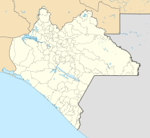
Coordinates: 16 ° 5 ′ N , 93 ° 45 ′ W Tonalá on the map of Chiapas
|
||
| Basic data | ||
| Country | Mexico | |
| State | Chiapas | |
| Municipio | Tonalá | |
| City foundation | 1529 | |
| Residents | 35,322 (2010) | |
| - in the metropolitan area | 84,594 | |
| Detailed data | ||
| height | 60 m | |
| Post Code | 30500 | |
| prefix | 966 | |
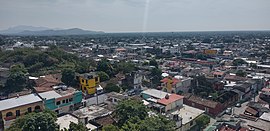
| Tonalá - city panorama (towards the sea) | ||
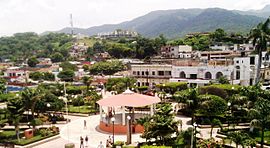
| View over Parque Central (towards the mountains) | ||
| The Cerro de Tres Picos (2460 m) is the highest point in the Tonalá hinterland | ||
Tonalá is a city in the northwest of the former Soconusco province in the Mexican state of Chiapas . It is the capital of the municipality of the same name .
Location and climate
Tonalá is located about 20 km from the Pacific coast at about 60 m above sea level; the city is about 260 km (driving distance) from the border with Guatemala at Ciudad Hidalgo . It is around 170 km to Tuxtla Gutiérrez , the capital of Chiapas; to Mexico City the distance is about 860 km. Throughout the year the weather is almost consistently hot and rainy: 30–45 ° C with 70–90% humidity ( tropical climate ); the hottest month is April, the coldest is December, although the daytime temperatures are 25–30 ° C even in winter.
Toponym
The Nahuatl name tonallan roughly means 'sunny and hot place' and refers to the many hours of sunshine during the day and the almost tropical and humid climate.
economy
The sunny and humid and hot climate is ideal for growing vegetables (tomatoes, pumpkins, cucumbers, lettuce, etc.) and other sun- and water-loving crops (bananas, mangos, etc.), which can be grown by refrigerated truck or by train be transported to the densely populated central Mexican highlands. The mountainous hinterland is ideal for growing coffee. Fishing is carried out in the coastal lakes and near the coast; in addition, the wide beaches of the Pacific play a role in the developing tourism.
history
The area around Tonalá was already settled in pre-Hispanic times; So far, 14 smaller archaeological sites have been discovered in the administrative district ( municipio ), including the city of Tonalá itself. The most important find was a skull covered with thin gold stripes and a jade mosaic . Some of the finds are in the Museo Arqueológico de Tonalá , others in the Museo Regional de Chiapas in Tuxtla Gutierrez; the skull is shown in the Museo Arqueológico del Soconusco en Tapachula .
In the 15th century the area came under the rule of the Aztecs , who were replaced by the Spanish under the leadership of Pedro de Alvarados in 1523/4 . Parts of the manor belonged to Hernán Cortés , but fell to the Spanish crown in 1529. Dominicans and Franciscans began setting up mission stations as early as the late 1520s . The area around Tonalá and Tapachula , thus the area of the former province of Soconusco, initially belonged to the judicial district ( Real Audiencia ) of México, but was annexed to the Audiencia of Guatemala in 1543. In 1568, the Spanish Crown created the General Capitanate of Guatemala , whose rule extended from Chiapas to Costa Rica and which lasted until the independence of Mexico (1821).
In 1813 Tonalá received city rights and thus a certain independence from the local manors and regional administrative institutions. After Mexico gained independence in 1821, Chiapas was also annexed by Mexico - despite its close cultural and historical ties to Guatemala; A dispute arose over this with Guatemala, which was not settled until 1882. The Río Suchiate was set as the state border and so only a small part of the former province of Soconusco remained near Guatemala - the much larger part of Chiapas from then on belonged to Mexico.
Attractions
- City center
- The Museo Arqueológico de Tonalá displays finds from the archaeological sites in the area.
- The Parque Central Esperanza in the city center is particularly lively in the cooler evenings. An approximately 4.70 m high Tlaloc stele from the Los Horcones site was erected here; Another approximately 2.85 m high stele depicting a seated jaguar is located in Parque Mariano Matamoros in the suburb of Colonia Evolución . Both steles are likely to date from around the 2nd or 3rd century AD.
- The former monastery church of San Francisco de Asís with its large forecourt was originally from the late 16th century, but was redesigned in the late 18th century; it is located two streets north of the center.
- Surroundings
- About 4 km north of the city center are the ruins of a pre-Hispanic city (called Iglesia Vieja ) with remains of buildings, steles, zoomorphic altar stones, etc.
- For those interested in archeology, a trip to the archaeological sites in the municipality of Tonalá is worthwhile.
- The La Sepultura biosphere reserve, about 15 km to the north, is ideal for hiking.
- The beaches of Puerto Arista , Boca del Cielo and Playa del Sol as well as the fishing village of Paredón are worth one or more excursions.
Individual evidence
- ↑ a b Archaeological sites in the Municipio Tonalá ( Memento of the original from October 19, 2013 in the Internet Archive ) Info: The archive link was inserted automatically and has not yet been checked. Please check the original and archive link according to the instructions and then remove this notice. (PDF; 5.1 MB)
- ↑ Skull from Tonalá in the Museo Arqueológico del Soconusco en Tapachula
Web links
- City website - photos + info (Spanish)


