
Weinfelder Maar
The Weinfelder Maar , also known as Totenmaar , is a maar around two kilometers southeast of the town of Daun in the Eifel , Rhineland-Palatinate .

geography
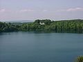
The maar lake was formed around 10,500 years ago in a volcanic steam explosion and is around 525 m long, 375 m wide and 51 m deep. The water surface is about 16.8 ha . The maar lies at a height of 483.5 m above sea level. NHN . The tuff wall surrounding the lake is higher on the western and southern sides than on the north and east. In the course of this wall are the Mäuseberg ( 561.2 m ) and the Maarkreuz ( 534.5 m ). The area of the lake is now a nature reserve . Bathing in the maar is prohibited.
Naming

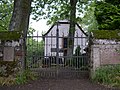
The name "Totenmaar" comes from the cemetery in the immediate vicinity of the maar with a small chapel, some of which dates from the 14th century. This is the former parish church of Weinfeld . The village was abandoned in the 16th century (last documented mention in 1512) due to the plague .
The chapel and the adjoining cemetery are used today by the community of Schalkenmehren for burials. In the entrance area of the chapel there are numerous thank you plaques with dedications such as: "Maria helped."
Say
There are many legends about the quiet Totenmaar. According to one of the legends, a castle is said to have stood here once, in which a benevolent count lived with his servants, his hard-hearted wife and his only child. One day the count returned home from the hunt and found only a lake at the place where his castle had stood. It was sunk into the ground with all its inhabitants, leaving behind a lake, the dead maar. As if by a miracle, a cradle appeared on the surface, in which his child drifted safely to the shore. The Count's horse scraped a spring from the ground during an exclamation from his master. The count later built a chapel out of gratitude for the salvation of his child, which, like the spring, has been preserved.
_b_179.jpg)
The Eifel painter Richard Franzen from Mehren dedicated the following poem to this maar:
The chapel still stands up there,
here in the beautiful Eifel region,
where
the village of Weinfeld once stood a few hundred years ago .
Plague and poverty, bad times,
forced people in need
to leave their homes,
last train in the sunset.
But
quiet sleepers return to Weinfeld year after year to
rest forever
on the mountain on the Totenmaar
- Views

In summer

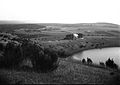
Chapel on the Maar

View from the cemetery
Weinfelder Church with a view of the cemetery
In late summer

In early summer
between 1895 and 1904


See also
literature
- Werner P. d´Hein: National Geopark Vulkanland Eifel. A nature and culture guide. Gaasterland-Verlag, Düsseldorf 2006, ISBN 3-935873-15-8
Individual evidence
- ↑ Map service of the landscape information system of the Rhineland-Palatinate nature conservation administration (LANIS map) ( notes )
- ↑ eifelreise.de: Weinfelder Maar
Web links

Ahbachtal | On the mountain near Walsdorf | At the Haidepütz near Walsdorf | To the ends near Walsdorf | On the large shed near Berndorf | On the brook near Berndorf | On the heath near Stadtkyll | On Klein-Pamet near Walsdorf | On Lind near Esch | On Seckerath near Mirbach | Barsberg | Baumberg near Wiesbaum | Dauner Maar: Gemündener Maar , Weinfelder Maar (Totenmaar) , Schalkenmehrener Maar | The Büdden near Oberbettingen | Dreiser Weiher with Döhmberg and Börchen | Duppacher Maar | Ice caves and Fischbachtal near Birresborn | Ernstberg | Eusberg near Mirbach | Geisert at Demerath | Gerolsteiner Dolomites (Auberg, Munterley, Hustley, Papenkaule and Juddenkirchhof) | Holzmaar | Hönselberg | Hundsbachtal | In the rock near Birresborn | In the great Reth near Zilsdorf | In the Hirtenberg near Feusdorf | In the calf pesch in front of Birkelswieschen near Zilsdorf | Immerather Maar | Kauligenberg near Mirbach | Kirchweiler Rohr | Kobergswiese near Berndorf | Mäuerchenberg, Hierenberg and Pinnert near Gönnersdorf | Hochkelberg with Mosbrucher Weiher | Möschelberg near Lissendorf | Mürmes | Nerother head | Pulvermaar with Römerberg and Strohn fairy tales | Remmelbachtal and Braunebachtal near Mürlenbach | Sängscheid near Stadtkyll | Sangweiher | Trilobite fields near Gees | Under the forest near Walsdorf | Steinbüchel at Schüller | Kalem volcano | Juniper area near Demerath | Juniper site near Bleckhausen | Winterberg near Wiesbaum | Wirfttal near Stadtkyll
Coordinates: 50 ° 10 ′ 35 ″ N , 6 ° 51 ′ 1 ″ E