
Westerwald lakes

The Westerwald Lake are seven dams on the Westerwald Lake District in Westerwald ( Rhineland-Palatinate ), mostly as because of their shallow depth pond or pond are called. They are located within the four cities of Hachenburg , Westerburg , Montabaur and Dierdorf .
geography
The Westerwald Lake District is an undulating plateau that begins at the mountain tops of the Hachenburger Wald in the north and extends to the Saynbach valley in the south . As a special natural area unit of the Upper Westerwald she seals it in the West, where the Herschbach -Dierdorfer pool the boundary between high- and low-Westerwald marked.
The rise of the mountains out of the basin almost looks like a wall in which the young Saynbach alone has dug a deep notch. The area itself is at an altitude of 400 to 420 m . Outside in the Hachenburger Forst on Glietzebeul, the terrain rises to 494 m and falls in the Sayntal near Zürbach to 340 m .
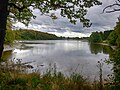
The lake group comprises seven still waters of shallow depth and very different sizes:
- Dreifelder Weiher , also Seeweiher - 123 hectares
- Haidenweiher - 28.8 hectares
- Brinkenweiher - 21.4 hectares
- Hofmannsweiher - 16.3 hectares
- Post pond - 13.3 hectares
- House pond - 9.6 hectares
- Wölferlinger Weiher - 1 hectare

Dreifelder pond

Haidenweiher

Brinkenweiher
Post pond


At Dreifelden the Dreifelder Weiher, the Haidenweiher and the Hofmannsweiher spread out. Dreifelder and Haidenweiher are fed by the Wied , the Hofmannsweiher by their left source tributary Fehlchesbach . In Freilingen and stones , the Brink pond, the pond and the Post House Weiher extend. They were created by damming the Holzbach , which later flows into the Wied from the left. A little off the beaten track, north-east of the village of the same name, is the Wölferlinger Weiher, which has largely silted up and receives its water from the Saynbach.

history
All seven ponds are human work. In their current form, they were created in the 17th century. At first they were all used for fish farming . The ponds of the Dreifelder Group are connected to each other by canals, as are those of the Freilinger Group.
As documents from the 12th century show, monks from monasteries in the region were already intensively farming fish. They created the first large ponds in a swamp, including the lake pond. Around 1650, Count Friedrich von Wied (1618–1698) had existing ponds enlarged and new ones created. This is how the seven large fish ponds were created with a total water surface of over 1000 acres . The annual draining of the water and the associated fishing move in autumn is a regional event.
After the Principality of Wied owned the Westerwald Lake District for 350 years, it sold the seven lakes to the NABU Foundation for National Natural Heritage in November 2019 . In cooperation with the state of Rhineland-Palatinate , the NABU Foundation has since been committed to the permanent preservation of the lake landscape.

Historic milestone on the K 61

Nature reserve

Landscape protection area


Conservation and Tourism
The Brinkenweiher, the Haidenweiher, the Wölferlinger Weiher and the southern parts of the Dreifelder Weiher have meanwhile been declared a nature reserve. There are numerous waders and water birds that stop on the migration route or are breeding birds .
The 32 km long Sieben-Weiher-Weg , which runs along the seven lakes, is a tourist attraction . It is identified by a blue seven and blue wavy lines. Most of the markings are glued or painted on to posts and trees. The campsite at Dreifelder Weiher can serve as a starting point. The path leads to Hartenfels via Steinebach , past the Hofmanns and Haidenweiher . The path continues between the Haus, Brinken and Postweiher to Freilingen , from there to Wölferlingen and to the local Wölferlinger Weiher. At Dreifelden, the path leads back along the Dreifelder Weiher to the starting point.
Web links
Individual evidence
- ↑ 7-Weiher-Weg. Urlaub.westerwald.info, accessed on April 29, 2016 .
- ↑ Westerwald Lake District has a new owner . SWR, accessed on May 6, 2020.
- ↑ 7-Weiher-Weg. Tourist-Information Hachenburger Westerwald, accessed on January 12, 2020 .
Coordinates: 50 ° 34 ′ 51 ″ N , 7 ° 50 ′ 19 ″ E