Trambouze
| Trambouze | ||
|
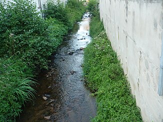
The river in Pont-Trambouze |
||
| Data | ||
| Water code | FR : K0954000 | |
| location | France , Auvergne-Rhône-Alpes region | |
| River system | Loire | |
| Drain over | Rhins → Loire → Atlantic Ocean | |
| source | in the parish of Cours 46 ° 7 ′ 44 ″ N , 4 ° 20 ′ 59 ″ E |
|
| Source height | approx. 687 m | |
| muzzle | on the municipal boundary of Montagny and Saint-Victor-sur-Rhins in the Rhins coordinates: 45 ° 59 ′ 56 ″ N , 4 ° 14 ′ 29 ″ E 45 ° 59 ′ 56 ″ N , 4 ° 14 ′ 29 ″ E |
|
| Mouth height | approx. 331 m | |
| Height difference | approx. 356 m | |
| Bottom slope | approx. 18 ‰ | |
| length | 20 km | |
The Trambouze is a river in France that runs in the Auvergne-Rhône-Alpes region . It rises in the municipality of Cours , generally drains in a south-westerly direction and flows into the Rhins as a right tributary after around 20 kilometers at the municipal boundary of Montagny and Saint-Victor-sur- Rhins . On its way, the Trambouze crosses the Rhône and Loire departments .
Places on the river
(Order in flow direction)
- La Ville , municipality of Cours
- Cours-la-Ville , parish of Cours
- Chassignol , Sevelinges municipality
- Pont-Trambouze , municipality of Cours
- Bourg-de-Thizy , municipality of Thizy-les-Bourgs
- Le Moulin de Basculon , municipality of Combre
- Le Moulin du Vierre , parish of Saint-Victor-sur-Rhins
- La Tombée , municipality of Montagny
Web links
Commons : Trambouze - collection of images, videos and audio files
