Trêsminas

Coordinates: 41 ° 30 ′ 12.4 " N , 7 ° 30 ′ 7" W.
Trêsminas (also Três Minas ) was a Roman gold mine in the district of Vila Pouca de Aguiar in northern Portugal . The site is in the Trás-os-Montes mountains between Braga and Bragança , near the Tresminas named after him . The rock , which is also silver - and Leaded has been mostly broken open pit.
The ancient mining area covers a total area of around two square kilometers. The ancient cuttings, pits and tunnels are easily recognizable thanks to the fact that no later interventions were made here and make Três Minas an archaeologically important monument for the study of Roman mining technology and its infrastructure .
The exploitation of the mines apparently began soon after the conquest of the later province of Lusitania by Augustus 27-26 BC. BC, which also had the aim of gaining control of the remaining ore deposits of the Iberian Peninsula . There is no reliable information about the amount of gold mined there. A clue are the 6.5 tons that Pliny the Elder , curator of the Hispania Tarraconensis province in the years 72–74 AD, names for extraction from secondary deposits.
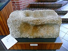
He mentions the following work steps for processing the material: tamping, sieving, grinding, washing and melting. Archaeological evidence of these activities are remnants of stamping works for crushing the ore rock (see photo). The enormous water requirement (also for the conveyor technology) was covered by dams and aqueducts .
- Corta de Covas is a canyon whose shape was caused by mining.
- the steps at Corta da Ribeirinha were cut into the 100 m high steep slope by the opencast mine.
- Corta dos Lagoinhos is the only example of an underground mine. The collapsed tunnel is now visible as a 60 m long, 5-6 m wide and 9 m deep cut in the terrain.
- five tunnels were used to convey the rock and drainage. Their width, the track lanes and the passing points are evidence of transport by barrows.
- the Galeria do Pilar is a 250 m long, dead straight tunnel with a brick pillar that supports a light shaft. There was a lift in the round, lower anteroom.
To exploit the ore deposits in the northwest of the Iberian Peninsula , the Romans built an infrastructure of roads and bridges (for example the bridge of Chaves ). The end of the region's mines seems to have come at the beginning of the 3rd century under Emperor Septimius Severus (146–211).
In 2010, measurements were made using a 3D laser scanner in the 140 m long “Galeria dos Alargamentos”, which is accessible to visitors.
literature
- Jürgen Wahl: Três Minas. Preliminary report on the archaeological investigations in the area of the Roman gold mine 1986/87 . In: Madrider Mitteilungen 29, 1988, ISSN 0418-9744 , pp. 221-244.
- Thomas G. Schattner (Ed.): Archaeological guide through Portugal (= cultural history of the ancient world . Vol. 74). Philipp von Zabern, Mainz 1998, ISBN 3-8053-2313-1 p. 78
Individual evidence
- ^ Jürgen Wahl: Roman gold mining in Trás-os-Montes . In: Great moments of archeology: Finds in Portugal . Muster-Schmidt-Verlag, Göttingen / Zurich 1993, ISBN 3-7881-1512-2 , p. 139-157 .
- ↑ Regula Wahl-Clerici: With 3D underground - on the trail of Roman mining engineers . In: AID . tape 27 , no. 2 , 2011, p. 54-55 .
Web links
- Projecto - Três Minas (German / English / Portuguese)
