Trischendamm
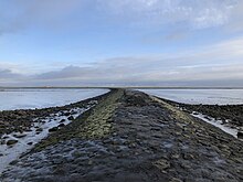
The Trischendamm is a coastal protection structure in the tip of the municipality of Friedrichskoog . It was built in 1935/36 with a length of 2200 meters (including the preparatory work 2400 meters) and a height of at least three meters above sea level. Therefore, it can also be used regularly during floods, only in the case of exceptionally high floods, usually in connection with wind, safe access is no longer possible if the dam is not flooded anyway. Today the dam leads as a hiking trail through salt marshes and mud flats out into the North Sea .
prehistory
When the Friedrichskoog was dyed in 1856, a 300 to 600 meter deep sub-area of the "Old Field" was left as a dike foreland on its south-west side to secure the new dike and prepared with groynes and parapets for further land reclamation . In spite of all efforts, however, the foreland north of the Friedrichskooger Hafenpriel was continuously lost, in particular due to the "Altfelder Priel " which partly ran parallel to the dike . As historical aerial photographs show, in 1935 the creek had approached the foot of the dike up to about 30 m and reached a depth of up to ten meters.
Construction planning
As early as the end of the 1920s, the dike associations combined in the Schleswig-Holstein Marsh Association and the Prussian administration responsible for coastal protection developed alternatives for how the dyke should be secured. Among other things, it has been considered, the Altfelder Tide to by insulation and to the models of Hamburger holm , north beach and Langeneß long, fixed connection between the Friedrichskoog and at the seaward edge of an approximately 14 km Watt back Marner Plate located island Trischen produce; the Trischenkoog was diked there from 1922 to 1925 . In 1933, the province of Schleswig-Holstein took up these considerations (which were not implemented due to the global economic crisis, among other things ) with regard to the job creation measures initiated by the National Socialists , and measures to secure the Kooges had become urgent.
In order to safeguard the construction project and against the background of major changes in the Wadden Sea , the West Coast Research Center, founded in Büsum in 1934, carried out flow measurements, among other things. These showed that the ridge was heavily overflowed as the tides ran from north to south or in the direction of the Elbe . Therefore the plan for a continuous connection between Friedrichskoog and Trischenkoog was dropped. To protect the Friedrichskoog, the construction of a stage-like dam about two and a half to three kilometers long, which should not hinder the flow conditions in the long term, seemed more optimal.
Construction phase
In order to implement the outlined building project, a bridge over the Altfelder Priel and a field railway for the transport of the building materials were built in 1935 ; a total of 16,000 tons of stones were used for the dam.
During the further work it became clear that the creek had already become much thicker than expected. This had reached such a high flow speed that the stones that were poured into it were carried away by the water and only sank to the ground far away. Therefore it had to be poured with the current in order to successfully close the dam.
Even during the construction work in 1936 it turned out that, contrary to the calculations, a relatively short dam already massively changed the flow conditions in the tidal flats. Apparently this also had a negative effect on the island of Trischen and the Koog there; During the storm surge on October 18, 1936, the Trischenkoog dyke broke and the island threatened to collapse. Against this background, construction was completed at the current length of 2200 meters.
After the end of World War II, further improvements and reinforcements were made to the dam. The Trischenkoog was abandoned after dyke breaches in 1930, 1936, 1940 and 1943; Today Trischen is a (mostly uninhabited) bird island.
Consequences
As expected, the Altfelder Priel began to silt up and the goal of securing the Friedrichskoog was achieved. Due to the large tidal range , it took until the 1980s for salt marshes to emerge on the southern side of the Trischendamm . From the top of the dam, the Puttschipploch and Krabbenloch (access to the former port of Friedrichskoog) can be seen.
Today's course and condition
The dam leads straight ahead from the top of the dyke and has two steps in height to describe a slight curve to the right after about 1100 m. At the end of the lake, when the tide is low, it can be seen that preliminary work had already been carried out for the continuation.
The outside of the dam is made up of large basalt blocks . In 1964 the crown of the Trischendamm was paved over a length of 2200 meters in order to create a spectacular "hiking trail" for Friedrichskoog, which has been a tourist destination since the 1950s . Stones with distance information are embedded in the dam every 100 meters.
Especially in the winter months suffers asphalt pavement in floods , partly this was missing for years on long sections, such as during the 2000s from 1.1 kilometer to the seaward end of the dam. Currently, the path is very uneven and partly full of holes, especially between the 0.9 to 1.4 kilometer stones (as of January 2020), but it is still used for tourism. Along the dam there are a number of information boards about the Wadden Sea , but these will be dismantled over the winter to protect against destruction by storm surges. In 1975 the dam was almost completely in the tidal flats, but today several hundred meters of foreland has grown on its south side (the left side as seen from land) and the first signs of this are also clearly visible on the north side.
From the entire dam there are - depending on the weather - good to very good visibility over the Elbe estuary to Cuxhaven and in the other direction to Büsum . More than ten kilometers behind the end of the dam is the Mittelplate oil production platform .
curiosity
At the confluence of the dam with the Friedrichskoog main dike, a sign indicates a dam length of 2,400 meters. According to the stones with the distance information, however, the dam is only 2200 meters long, the last distance stone is already in the slope at the top of the dam. The discrepancy in the length data results from the difference between the completed dam (2200 meters) and the preparatory work that has already been carried out for the foundation (another 200 meters, still visible at low water).
Others
A few hundred meters south of the Trischendamms is the outlet of the 1972/73 built pumping station Friedrichskoog, the pumping capacity of 2 x 300 l / s: dehydrated and an area of 100 ha (as of May 2008).
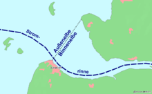
The imaginary line between the Kugelbake in Cuxhaven and the beginning of the Trischendamm on the sea dike marks the end of the Inner Elbe and the beginning of the Outer Elbe.
In May 2019 a concept for the further expansion and tourist attraction of the Trischendamm was presented; The implementation planning should be completed by summer 2020 .
literature
- Kurzeitung of the community Friedrichskoog, born 1978.
- Wilhelm Stock: Chronicle of the community Friedrichskoog. Meerland on the shores of the North Sea , published by the municipality of Friedrichskoog, Friedrichskoog 1979.
- Peter Wieland: Coastal protection and internal drainage in Dithmarschen , in: German Association for Water Management and Culture Building eV (Ed.): Historischer Küstenschutz , Stuttgart 1992, p. 365 to 401, on Altfelder Priel: p. 385 f.
- Deich- und Hauptsielverband Dithmarschen (ed.): Chronicle of the Deich- und Hauptsielverband Dithmarschen , Vol. I: Historical presentation, legal basis, formation of water and soil associations and association activities , 2nd edition, Hemmingstedt 2008, p. 285.
Web links
Individual evidence
- ^ A b Johann M. Lorenzen: 25 years of research in the service of coastal protection, in: The Coast, 1960, issue 8, page 10 f. , accessed January 25, 2020
- ↑ Bruun & Möllers: Expansion & Attractiveness Trischendamm, May 15, 2019 , accessed January 23, 2020
Coordinates: 54 ° 1 ′ 27 ″ N , 8 ° 48 ′ 55 ″ E


