
Tropical Storm Arlene (1959)
| Tropical Storm ( SSHWS ) | ||
|---|---|---|
 |
||
| Emergence | May 28, 1959 | |
| resolution | May 31, 1959 | |
|
Peak wind speed |
|
|
| Lowest air pressure | 1000 mbar ( hPa ; 29.5 inHg ) | |
| dead | 1 indirect | |
| Property damage | US $ 500,000 (1959) | |
|
Affected areas |
Louisiana , Texas , Mississippi , Alabama , Georgia, and South Carolina | |
| Season overview: 1959 Atlantic hurricane season |
||
Tropical Storm Arlene was a short-lived tropical cyclone that developed a few days before the start of the 1959 Atlantic hurricane season and that landed in central Louisiana on May 30 , killing one person indirectly. Arlene's development was slow before the system could gain enough convection to be classified as Tropical Storm Arlene on May 28th. The storm slowly intensified and reached its greatest strength on May 30th with peak wind speeds of 95 km / h. The storm weakened rapidly near the land and during the night the storm reached overland with winds of 75 km / h. Arlene weakened to a tropical depression the next morning according to today's criteria. The system crashed to a residual low on the afternoon of May 31st and broke up over South Carolina late on June 2nd .
Arlene dumped up to 300 mm of precipitation locally over the southeastern United States, with the highest value of 333.5 mm in Houma accumulating within three days. The torrential rain results in minor flooding in Louisiana and property damage totaled $ 500,000 (in 1959 prices). One death was indirectly attributed to the storm when a man drowned in the stormy seas off the coast of Texas .
Storm course
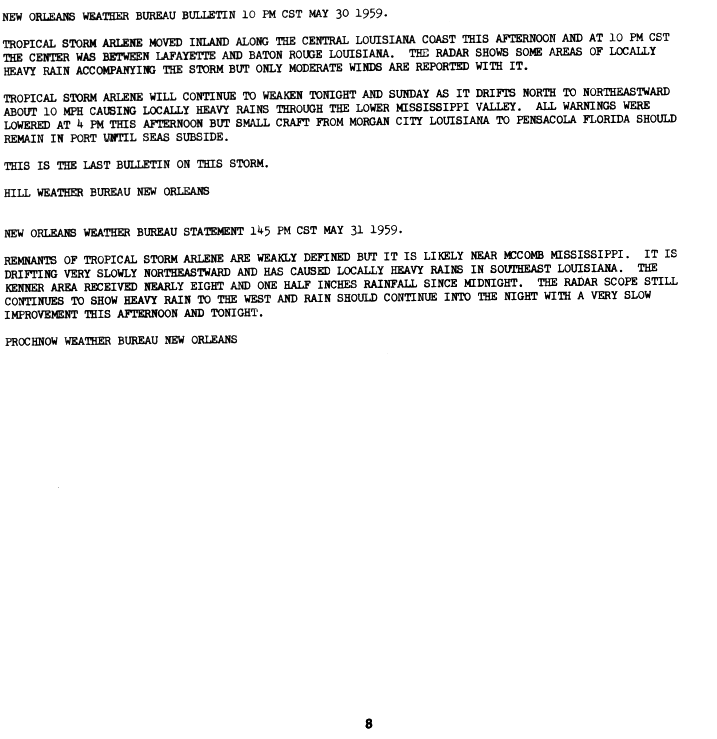
Tropical Storm Arlene evolved from a tropical wave first seen near the Dominican Republic on May 23 . This wave developed slowly as it moved westward through the Caribbean Sea . It developed into a depression on May 25th that entered the Gulf of Mexico two days later , and weather observation by a ship the next day revealed that the system had developed a closed circulation . Early the following day, the system was determined to have developed into the first tropical storm of the 1959 Atlantic hurricane season, which was given the name Arlene, when the center was about 480 km south-southeast of New Orleans , Louisiana and was ongoing Winds reached a speed of 65 km / h. Arlene moved northwest at a forward speed of 15 to 25 km / h and slowly intensified during the day. On May 29, Arlene turned more west and forward speed decreased. During the night, Arlene became almost stationary. The storm was about 150 miles south of Lafayette when it drifted further north and the peak of the storm was estimated to be 85 km / h. In the follow-up analysis, however, it was found that the time of Arlene's greatest strength was shortly before reaching the mainland with wind speeds of around 95 km / h. As Arlene neared the coast, the storm began to ease due to the effects of the land. Arlene crossed the coastline about 65 km southeast of Lafayette, Louisiana at 4:00 p.m. CST with wind speeds of 75 km / h, as the post-analysis showed, operationally this speed was assumed to be 85 km / h. Arlene weakened rapidly overland, according to today's criteria to a tropical low pressure area and dissolved to a residual low on May 31st. The residual low hung over the southern United States until June 2, when it finally dissolved over South Carolina .
Preparations and implications
The low that eventually became Arlene resulted in wind warnings and small craft recommendations for both coasts in southern Florida on May 27 . When the low was upgraded to tropical storm the next day, the warnings for small craft were expanded significantly. They now covered the section from Sabine Pass , Texas to Saint Marks , Florida. Storm warnings covered the section between Morgan City , Louisiana and Pascagoula , Mississippi . A storm surge was expected for this section, which should reach 0.6–1.2 m above normal. As Arlene neared the coast, the small craft warnings were lifted south of Pensacola , but expanded westward to Galveston , Texas. The warning of a tropical storm now covered the stretch of coast from Galveston to Grand Isle , Louisiana.
Arlene's wind speeds reached up to 95 km / h with gusts of up to 120 km / h. The lowest air pressure over land was 29.52 inHg , which corresponds to about 1000 mbar (hPa). The storm surge reached up to 90 cm on Weeks Island and at Point Au Fer, Louisiana. Local rainfall was recorded within the state, with a maximum of 333.5 mm recorded in Houma . The remaining low brought rain down to southern Georgia. In some places damage from overflowing rivers and the harvest was reported, but this was generally low. Total caused Arlene damages in the amount of 500,000 US dollars (1959). One person lost his life indirectly through Arlene - the man drowned in the rough seas off the coast near Galveston.
Names and weather records
Because of the minimal impact, the name was not deleted and used again, namely in 1963 , 1967 , 1971 , 1981 , 1987 , 1993 , 1999 and 2005 . It is on the list of names of tropical cyclones for 2011 and, with nine uses so far, is the most frequently used name for a tropical cyclone in the Atlantic basin since the name was started in 1950. On May 30, 1959, Arlene marked the earliest date to date on which a tropical cyclone landed in this state since the beginning of systematic weather records.
Individual evidence
- ↑ a b c d e Gordon E. Dunn and Staff: Monthly Weather Review for 1959 ( English , PDF; 14.8 MB) Weather Bureau Office. 1959. Retrieved November 3, 2008.
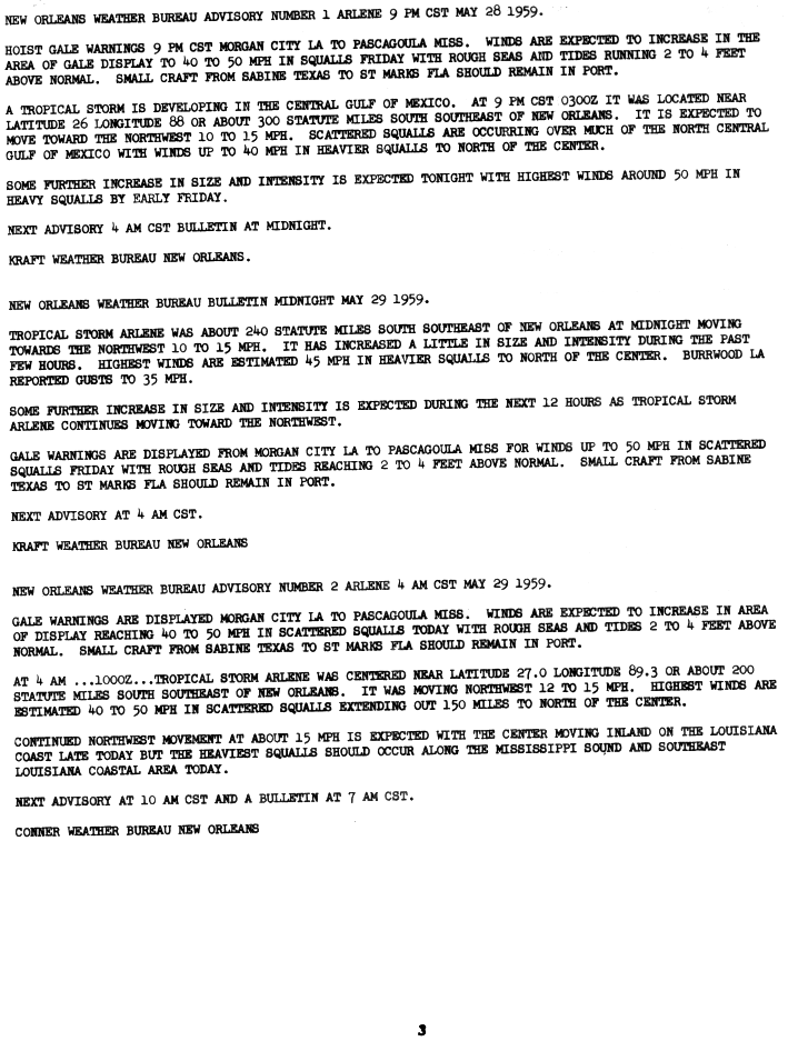
- ^ A b New Orleans Weather Bureau: Tropical Storm Arlene Advisories, Page One ( English , GIF) National Hurricane Center. 1959. Retrieved November 3, 2008.
- ^ A b New Orleans Weather Bureau: Tropical Storm Arlene Advisories, Page Three ( English , GIF) National Hurricane Center. 1959. Retrieved November 3, 2008.
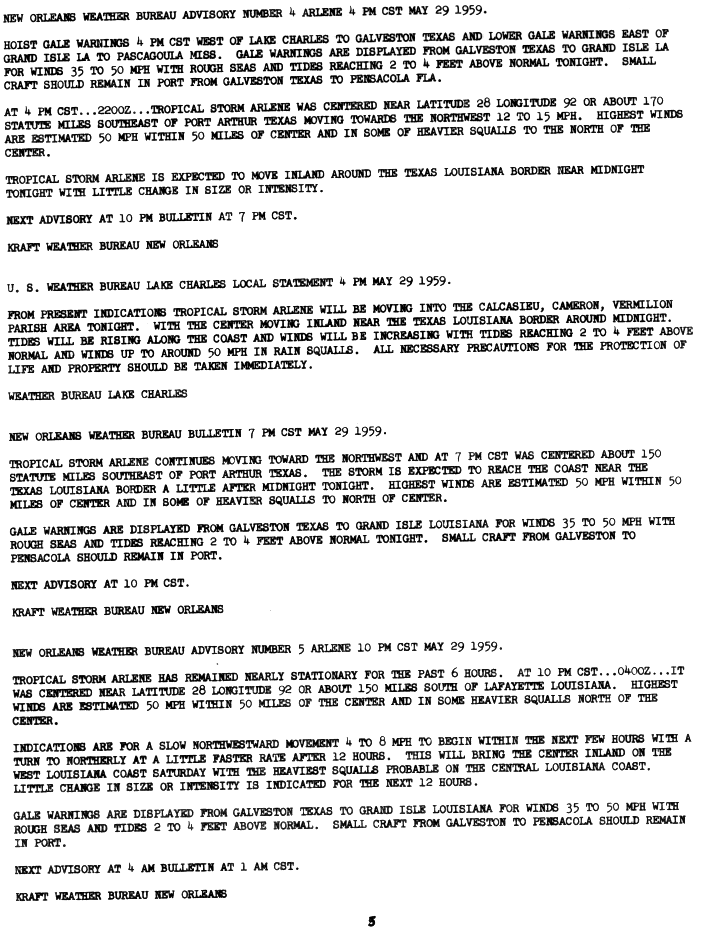
- ^ New Orleans Weather Bureau: Tropical Storm Arlene Advisories, Page Four ( English , GIF) National Hurricane Center. 1959. Retrieved November 3, 2008.
- ^ A b c Dan Vietor: Tropical Storm Arlene 1959 trackfile (Unisys) . Unisys Corporation. 2005. Archived from the original on August 8, 2008. Info: The archive link was automatically inserted and not yet checked. Please check the original and archive link according to the instructions and then remove this notice. Retrieved October 13, 2008.
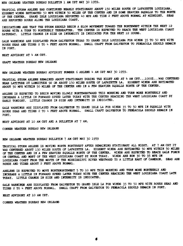
- ^ New Orleans Weather Bureau: Tropical Storm Arlene Advisories, Page Five ( English , GIF) National Hurricane Center. 1959. Retrieved October 13, 2008.
- ^ New Orleans Weather Bureau: Tropical Storm Arlene Advisories, Page Six . National Hurricane Center. 1959. Retrieved October 13, 2008.
- ^ NHC: Atlantic Best Tracks, 1851 to 2007 . National Hurricane Center. 2008. Retrieved October 13, 2008.
Web links
- Monthly Weather Review 1959 (PDF; 14.16 MB)