Tugela (river)
|
Tugela Thukela, uThukela |
||
|
Location of the Tugela in KwaZulu-Natal |
||
| Data | ||
| location |
|
|
| River system | Tugela | |
| source | Drakensberg 28 ° 45 ′ 54 ″ S , 28 ° 52 ′ 33 ″ E |
|
| Source height | about 3100 m | |
| muzzle | northeast of KwaDukuza in the Indian Ocean Coordinates: 29 ° 13 ′ 31 ″ S , 31 ° 29 ′ 54 ″ E, 29 ° 13 ′ 31 ″ S , 31 ° 29 ′ 54 ″ E |
|
| Mouth height | 0 m | |
| Height difference | about 3100 m | |
| Bottom slope | about 6.2 ‰ | |
| length | 502 km | |
| Catchment area | 29,101 km² | |
| Discharge at the Mandini gauge (1160880) A Eo : 28,920 km² Location: 74 km above the mouth |
NNQ (min. Month Ø) MNQ 1964–1986 MQ 1964–1986 Mq 1964–1986 MHQ 1964–1986 HHQ (max. Month Ø) |
1 m³ / s 12 m³ / s 100 m³ / s 3.5 l / (s km²) 386 m³ / s 1117 m³ / s |
| Left tributaries | Buffalo River | |
|
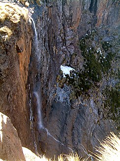
The Tugela Falls in the Royal Natal National Park ( Drakensberg , KwaZulu-Natal , South Africa). The Tugela has very little water in September. |
||
The Tugela ( isiZulu Thukela or uThukela ) is about 502 kilometers long and is the longest river in the South African province of KwaZulu-Natal . Its catchment area is 29,100 square kilometers. The name of the river is a Zulu term and means 'something that scares'.
As the border between Natal and KwaZulu, the river had historical significance in the region.
course
The river has its source in the Drakensberg in the area of Mont-Aux-Sources and runs in a south-easterly direction. The source of the Tugela is close to that of the Oranje , which is called Senqu in the upper reaches and flows off to the west. Shortly after its source region, it passes the Tugela Falls , at 947 meters the second highest waterfalls on earth. It flows into the Indian Ocean . The estuary is at Tugela Mouth between the cities of Richards Bay and Durban . It has the shape of an estuary .
Hydrometry
The flow rate of the river was measured for 22 years (1964–1986) in Mandini , 74 km above the mouth in m³ / s.

Reservoirs on the Tugela
The following dams are located on the Tugela:
- Driel Barrage ( Drieldam ). The plant forms a barrier below the Woodstock Dam at Bergville to from here the water in the Tugela Vaal channel ( Tuva main canal to pump) and in this way (via Mpandweni siphon in Woodstock Dam ) in the Jagersrust Balancing Dam to conduct
- Jagersrust Balancing Dam ( Jagersrust Forebay ), is a compensation basin on the Tugela Vaal Canal not far from Kilburn Dam and at the foot of the Drakensberg edge step. This is where the Jagersrust Pump Station is located, with the aid of which water reaches the Driekloof Dam in the Vaal catchment area via a pipeline and three tunnels ( T'Zamenkomst Tunnel , Grenshoek Tunnel , Metz Tunnel ) . Also, here water in the Kilburn Dam pumped, of the lower reservoir of the pumped storage power station Drakensberg Pumped Storage Scheme forms.
- Woodstock Dam . It is the most important water reservoir for the Tugela Vaal water transfer system ( Tugela Vaal Water Transfer Scheme ), in which a pumped storage power plant ( Drakensberg Pumped Storage Scheme ) is integrated further north of the reservoir .
- Spioenkop Dam . It regulates the flow of water below the Driel Barrage ( Drieldam ), supplies Ladysmith with water and keeps it ready for the farm irrigation downstream of the Tugela.
Tributaries
Important tributaries of the Tugela are:
-
Buffalo River
- on its tributary Ngagane River the Ntshingwayo Dam , formerly Chelmsford Dam , it supplies water for the supply of Newcastle, for cooling an Eskom power station and for irrigation of the farm
- on its tributary, the Slang River, the Zaaihoek Dam , it supplies water for the Thukela-Vaal-Transfer-System and for the Majuba power station
- Bloukrans River
- Bushman's River with Wagendrift Dam , it provides water for residents and businesses in Estcourt and for agricultural irrigation systems in the area
- Klip River , flows from the lower reservoir of the Ingula pumped storage plant from
-
Little Thukela River
- with the Bellpark Dam , which is primarily used for local recreation purposes
-
Mooi River
- on its tributary, the Mnyamvubu River, the Craigie Burn Dam , it is used for irrigation of citrus fruit plantations located downstream
- Sundays River , with the Slangdraai Dam
Individual evidence
- ↑ a b Homepage UNH / GRDC - The Tugela in Mandini. Retrieved July 2, 2020
- ↑ a b Umgeni Water : Infrastructure Master Plan 2019 . Pietermaritzburg 2019, online at www.umgeni.co.za (English, PDF document p. 20)
- ^ A b Michael Iwanowski: South Africa . Tips! for individual explorers. 19th completely revised edition. Reiseuchverlag Iwanowski, Dormagen 2010, ISBN 978-3-933041-87-6 , p. 616 f .
- ↑ Mphatheni Mthembu, Lungelo Madiya, Nombuso Gongo, Jennifer Cele: A survey in the Thukela estuary . Aquatic Ecosystem Research, University of KwaZulu Natal, at www.riversoflife.co.za (English)
- ↑ Umgeni Water : Infrastructure Master Plan 2019 . Pietermaritzburg 2019, online at www.umgeni.co.za (English, PDF document p. 39, 44–45, 47)
- ↑ a b Umgeni Water : Infrastructure Master Plan 2019 . Pietermaritzburg 2019, online at www.umgeni.co.za (English, PDF document p. 21)
- ^ Orange-Senqu River Commission (ORASECOM): Sterkfontein Dam . at www.wis.orasecom.org (English, PDF document)
- ↑ Rand Water : Transfer Schemes . on www.randwater.co.za (English)


