Turmberg (Karlsruhe)
| Turmberg | ||
|---|---|---|
|
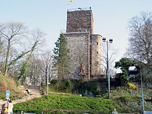
View of the Turmberg from the west |
||
| height | 257.2 m above sea level NHN | |
| location | at Durlach ; City of Karlsruhe , Baden-Württemberg ( Germany ) | |
| Mountains | Kraichgau | |
| Coordinates | 48 ° 59 ′ 51 ″ N , 8 ° 29 ′ 18 ″ E | |
|
|
||
| particularities | - Turmbergbahn Karlsruhe-Durlach - Turmberg ruins ( AT ) |
|
The Turmberg (formerly Hohenberg ) is 257.2 m above sea level. NHN high local mountain of the Karlsruhe district Durlach in Baden-Württemberg .
The tower ruin is located on the mountain , the remaining tower of which serves as a lookout tower. The Turmbergbahn , a funicular from 1888, leads up to it.
geography
The Turmberg lies in the border area between the Kraichgau and the Black Forest . In the natural spatial structure it is assigned to the Kraichgau. There are also representations that see it as the northernmost Black Forest height. The mountain peak consists of shell limestone , which is atypical for the Black Forest .
Northwest over west to south of the mountain is Durlach and to the northeast, Grötzingen , is another Karlsruhe district.
Development
The ruins of Durlach , also known as Turmberg or Hohenberg , are located on the area of the west-south-west slope of the Turmberg near the summit , the remaining tower of which serves as a lookout tower. It is a popular excursion destination and - when the view is clear - a valued vantage point with a view of the Rhine plain about 140 m below , across to the Palatinate Forest and Alsace .
Not far from the ruins on the summit plateau of the mountain is the Schöneck sports school , built in 1953 by the Badischer Fußballverband ( Badischer Fußballverband) , in which, among other things, the 1954 soccer world championship under Sepp Herberger prepared for the World Cup .
The Karlsruhe forest rope park is also located next to a large playground in the forest of the Turmberg.
The residential areas on the hillside of the Turmberg, with their view over the Rhine plain, are among the popular prominent and residential areas of Karlsruhe. On the plateau one kilometer south-east of the Turmberg is the Rittnerthof, which was set up in the second half of the 18th century at the instigation of Margravine Karoline Luise , which was converted by the architects Curjel & Moser for Eduard Merton at the beginning of the 20th century . FlowTex managing director Manfred Schmider later lived in a 60,000 square meter park-like part of the property with its own helipad .
Tower hill climb and tower mountain machine
The tower climb has been taking place since 2000 and is organized by the cycling department "die soffi" of the Karlsruhe Lemmings. The race track runs over a length of around 1800 meters from the northwest foot of the Turmberg in Durlach (corner of Grötzinger Straße, Nesslerstraße) up to the mountain station of the Turmbergbahn. Around 120 meters of altitude have to be overcome with an average gradient of 6.7%. The maximum gradient is 13%. The race is divided into a mountain time trial and one or two elimination races.
The so-called Turmbergomat is available all year round on the same route (except for the winter months) . This is a timing system that enables athletes to measure their personal time on the Turmberg by bike, hand bike or on foot. The route is identical to that of the tower climb, but slightly shorter at 1,750 m in length. It is marked on the road at 100 m intervals. Participants first take a card at the valley station on which they can enter their name. Then they stamp the current time on their card to the second at the valley station and start their mountain run or their ascent. At the finish, stamp the second time on your card at the mountain station and throw it into the mountain station for evaluation. The times are evaluated weekly and published on the operator's website.
literature
- Susanne Asche , Olivia Hochstrasser: Durlach - Staufer foundation, princely residence, citizen town . City of Karlsruhe, City Archives, ISBN 3-7617-0322-8 .
- Karl Gustav Fecht : History of the city of Durlach . Adolph Emmerling, Heidelberg 1869 (photomechanical reprint 1969 of the association of former students of the Markgrafen-Gymnasium).
- Christian Edel: Durlach a historical tour . Friends of the Pfinzgaumuseum - Historical Association Durlach e. V., Karlsruhe-Durlach 2004, ISBN 3-9803311-5-6 .
Web links
Individual evidence
- ↑ a b Map services of the Federal Agency for Nature Conservation ( information )
- ↑ Nature regions: mapping service of LUBW in "Nature and Landscape" → "natural areas", accessed on November 30, 2015
- ^ Rudolf Metz : Mineralogical and regional hikes in the northern Black Forest, especially in its old mining districts. 2nd, completely revised edition, Schauenburg , Lahr 1977, ISBN 3-7946-0128-9 , p. 368.
- ↑ Rittnerthof. In: Database of cultural monuments. City of Karlsruhe, accessed on May 4, 2019 .
- ↑ "Big Manni" loses luxury villa. In: Manager Magazin. September 27, 2006, accessed May 4, 2019 .
- ^ Association "The Lemmings eV" Website of the operator of the Turmbergomat in Durlach


