
Turmberg ruin (Karlsruhe)
| Turmberg ruin | ||
|---|---|---|
 |
||
| Alternative name (s): | Hohenberg Castle | |
| Castle type : | Höhenburg, spur location | |
| Conservation status: | Keep | |
| Standing position : | Nobles, counts | |
| Construction: | Humpback cuboid, sandstone | |
| Place: | Karlsruhe - Durlach | |
| Geographical location | 48 ° 59 '49 " N , 8 ° 29' 8" E | |
| Height: | 256 m above sea level NHN | |
|
||

The Turmberg ruin , formerly Hohenberg Castle , is the ruin of a spur castle at around 256 m above sea level. NHN on the spur of the Turmberg 1000 meters east of the center of Durlach, a district of Karlsruhe in Baden-Württemberg, and is now used as a lookout tower.
history
The castle was built in the second half of the 11th century by the Counts of Hohenberg as their ancestral seat . Other owners of the castle were the Counts of Grötzingen, the Hohenstaufen and the Margraves of Baden . In 1279 the castle was taken over by Bishop Konrad III. destroyed by Lichtenberg . In the middle of the 16th century only the keep , which was used as a keeper , was left standing .
investment
The former castle complex had a polygonal two-meter-thick circular wall , an approximately 12 m × 12 m large residential tower , a 25-meter-high keep made of sandstone - humpback ashlars with a high entrance 9 meters high on an area of approximately 11.70 m × 11 , 70 m with a wall thickness of 2.5 meters and a neck ditch .

The now approximately 32.3 meter high keep has been preserved and serves as a lookout tower. The lower of the two viewing platforms is 16.3 meters high and forms a bridge-like connection to the pillar to the west of the tower on which an alarm cannon or bell originally stood. The concrete staircase running in the keep leads to the upper second platform at a height of 29.6 meters, which offers a very good view of Karlsruhe, the Rhine plain and as far as the Palatinate Forest and the Vosges .
On the platform is a historical pillar of the European degree measurement from 1870 (renewed in 1951). On the valley side of the western pillar there is a plaque commemorating those who died in the First World War .
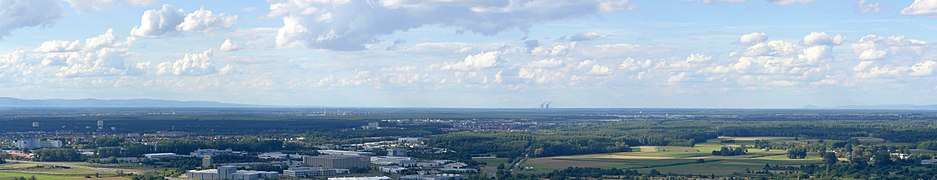
Panorama towards Hagsfeld

Panorama towards Karlsruhe


literature
- Max Miller (ed.): Handbook of the historical sites of Germany . Volume 6: Baden-Württemberg (= Kröner's pocket edition . Volume 276). Kröner, Stuttgart 1965, DNB 456882928 .
Web links
- Turmberg ruin in the database of cultural monuments of the city of Karlsruhe.
- Turmberg ruin at Burgenarchiv.de
- Historical reconstruction drawing
References and comments
- ↑ Map services of the Federal Agency for Nature Conservation ( information )
- ↑ a b c Height information according to private measurements with laser rangefinder